Welcome! Log In Create A New Profile Recent Posts
Half Dome from the Four Mile Trail to Glacier Point, Yosemite National Park

The Moon is Waxing Gibbous (56% of Full)


Advanced

Re: Old Big Oak Flat Road from Tamarack to the Valley (long)

All posts are those of the individual authors and the owner of this site does not endorse them. Content should be considered opinion and not fact until verified independently.

Old Big Oak Flat Road from Tamarack to the Valley (long)
June 28, 2010 07:27PM
This is #4 on my list of abandoned trails and off-trail hikes near Yosemite Valley. Don't worry, I'm not going to post them all.

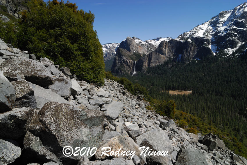
You want a hike that isn't overrun with people? This one qualifies, though it is on the sunny side of the valley and should be avoided on very hot days in the summer. The bottom mile qualifies as a great short round trip hike in its own right, as it provides the best view in the Valley of Bridalveil Falls, and is free of snow except in the depths of winter.

Feel free to add some photos taken yourself when you did this hike. mrcondon posted some from this hike on the recent Coulterville thread, though his first photo (of Tamarack Creek crossing) is on a different trail. http://yosemitenews.info/forum/read.php?3,26509,26517#msg-26517

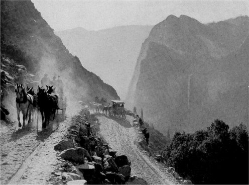
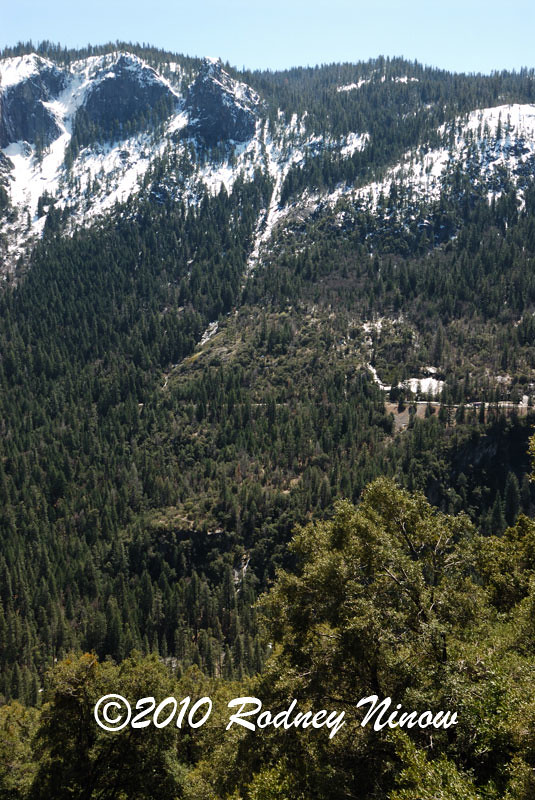
History: The Old Big Oak Flat Road was the main road into Yosemite from the north until the new Big Oak Flat Road (Rt. 41, Valley to Crane Flat) was built. At that time it immediately fell into disrepair as a road, because the talus field at the great switchback encroached a bit more every winter. However, it was maintained as a hiking trail long after that time.

There are several books on the history of these roads. This road was built in a race with the Coulterville Road. Both were originally toll roads. The Big Oak Flat Road was longer, but had much better views descending into the Valley. One feature on the road is Rainbow View, which still has a good pipe railing today. Just east of that was the only switchback on the road, and it was a beaut. It was somewhere near here where the famous pioneer hotelier James Hutchings was killed when his team ran away and he was thrown onto the boulders. http://www.yosemite.ca.us/library/yosemite_indians_and_other_sketches/james_hutchings.html


see http://www.yosemite.ca.us/library/one_hundred_years_in_yosemite/tourists.html#page_60

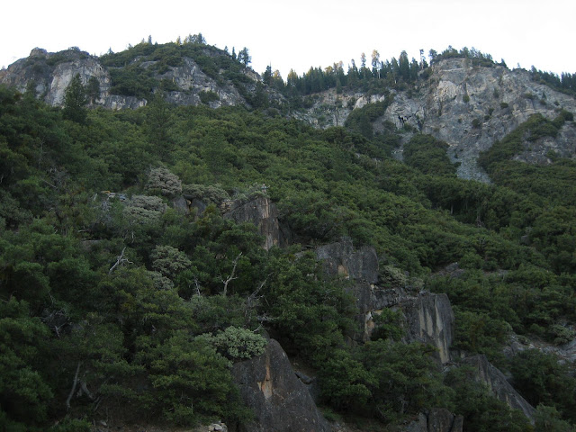
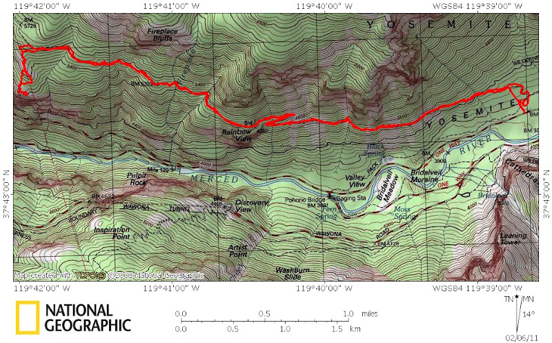
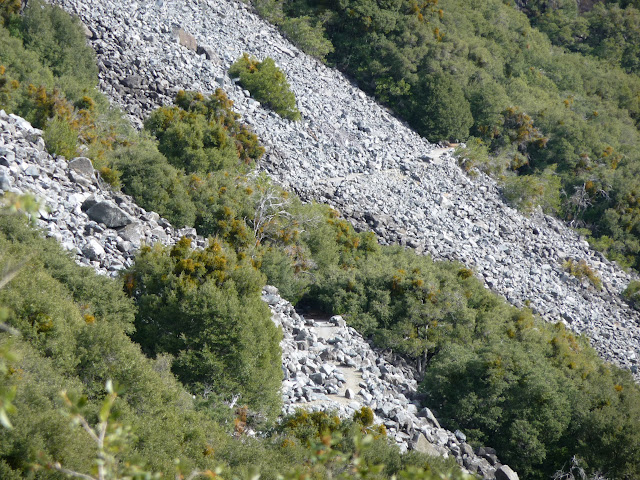
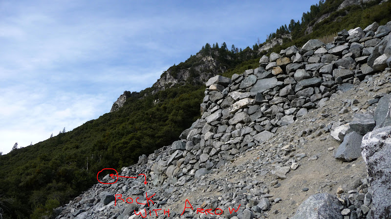
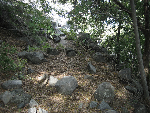
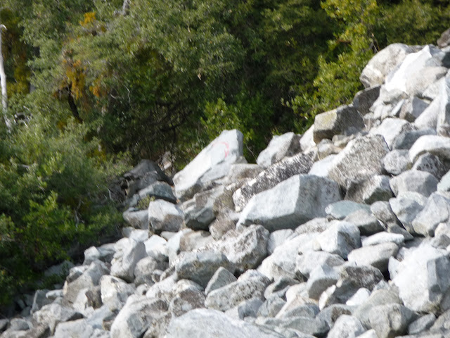
This switchback was situated in a major talus and boulder field. You can still see a bit of stonework just where the turn to the right was located, but otherwise it has disappeared completely. What you need to do here is descend among the talus about 150 vertical feet to the road where it can be seen going into the next band of trees to the east. Since this is where people get a bit lost, here are a couple more figures to give you the layout.
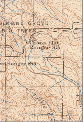
as a map:
http://mapper.acme.com/?ll=37.72558,-119.67175&z=14&t=T
http://docs.google.com/leaf?id=0B9ZDeFswongBYmRlODM3MGEtYTRmMy00NTdiLWJkZmQtNGY5OWVmMjEwY2Qw&hl=en

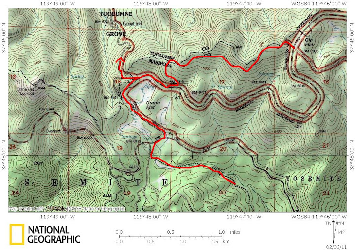
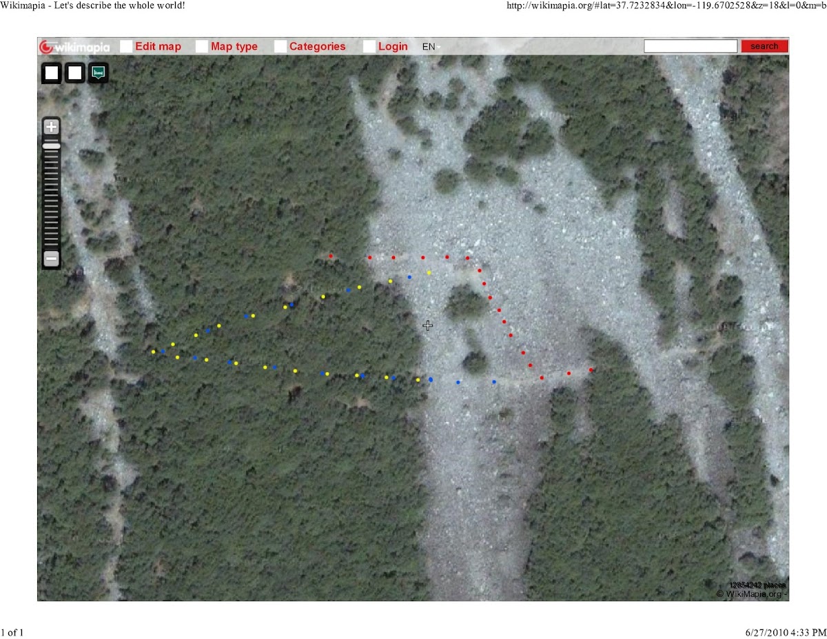
A blowup of the switchback:
http://wikimapia.org/#lat=37.7232834&lon=-119.6702528&z=18&l=0&m=b

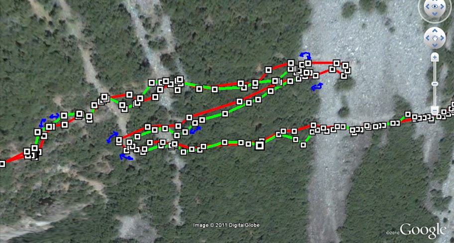
The view below shows the foot descent in red and the old switchback in blue and yellow.

http://docs.google.com/leaf?id=0B9ZDeFswongBZWNjZmVjOTItMTcxMi00ZTM1LWEzMjktMjcxMDUyNWIyYThl&hl=en

The 1974 edition of the High Sierra Hiking Guide to Yosemite Valley features this hike as being an easy, mostly asphalt 5 mile walk, with parking at the Cascade Creek crossing. By the 1985 edition, you had to park at the Tamarack Flat Campground, which adds 2.2 miles to the hike, or you can park at the Foresta trailhead, which adds 4 miles. It was still shown as a trail on the 1985 guidebook map. I remember that at that time it was marked "not a trail" by a sign at the top entry (N 37.7345, W119.70455), but someone had still been cutting through the windfalls and trimming the bushes to maintain it as an easy walk.

In recent years, this maintenance has stopped, and the windfalls and brush can slow you down. I would appreciate a comment from some someone who has done the trail this year about how much the trail has deteriorated. In spite of that, there is no route finding problem, except possibly at the missing switchback...see above. The only other obstacle is during high water, when the Fireplace Creek crossing can be difficult because the culvert is plugged. There are a couple of dry washouts, but they are easy enough to get across under normal conditions.

bill_e_q tells me that the rangers still recognize the old road as an off-trail wilderness hike route, and call it "Rockslides". He also mentions that he has posted photos of it in the past, but I haven't spotted those threads yet...

The Valley end is at Northside Drive (Rt. 140) a bit west of Ribbon Creek. Longitude W119.645. However, the park service has been using this area as a dumping ground for trees and windfalls that have been hauled off the roads, and which are left there for park residents to cut into firewood. Just follow the dirt road up the hill until it turns to the west, and you can see the gate that blocks the entrance to the old road.
avatar Re: Old Big Oak Flat Road from Tamarack to the Valley (long)
June 28, 2010 07:49PM
avatar Re: Old Big Oak Flat Road from Tamarack to the Valley (long)
June 28, 2010 08:00PM
Here's a view of the road before the switchback (looking east):


Edited 1 time(s). Last edit at 06/28/2010 10:29PM by bill-e-g.
avatar Re: Old Big Oak Flat Road from Tamarack to the Valley (long)
June 28, 2010 08:01PM
Here's more of the rockwork on the switchback:

Re: Old Big Oak Flat Road from Tamarack to the Valley (long)
June 28, 2010 09:42PM
Actually, unless the photo is reversed, that has to be looking east towards El Cap.
avatar Re: Old Big Oak Flat Road from Tamarack to the Valley (long)
June 28, 2010 10:30PM
Quote
wherever
Actually, unless the photo is reversed, that has to be looking east towards El Cap.

Yes, of course. Looking east (edited my post). Thx
avatar Re: Old Big Oak Flat Road from Tamarack to the Valley (long)
June 28, 2010 11:16PM
Quote
wherever
. . . snip . . .
The Valley end is at Northside Drive (Rt. 140) a bit west of Ribbon Creek. Longitude W119.645. However, the park service has been using this area as a dumping ground for
trees and windfalls that have been hauled off the roads, and which are left there for park residents to cut into firewood. Just follow the dirt road up the hill until it turns to the west, and you can see the gate that blocks the entrance to the old road.

I've heard it called the "Wood Lot".

The road that goes up past the "Wood Lot" and the the start of the hike is at pullout "V9" and is just past El Capitan meadow as you're driving out of the valley.
Re: Old Big Oak Flat Road from Tamarack to the Valley (long)
June 29, 2010 08:19AM
I did that hike a couple years ago. I think I got as far as Rainbow Point, based on my photos, but I never saw the railing. Here is a pano I shot handheld, which is why the funny edges. I chose not to crop them off.

avatar Re: Old Big Oak Flat Road from Tamarack to the Valley (long)
June 29, 2010 01:08PM
Quote
hotrod4x5
I chose not to crop them off.

Makes it look like you are coming out of a tunnel. winking smiley
avatar Re: Old Big Oak Flat Road from Tamarack to the Valley (long)
June 29, 2010 01:24PM
Quote
hotrod4x5
I did that hike a couple years ago. I think I got as far as Rainbow Point, based on my photos, but I never saw the railing.

You didn't go west enough. Rainbow View railing is pretty hard to miss. (I don't think you can)

(It was still up in Dec. 2008)


Edited 1 time(s). Last edit at 06/29/2010 01:24PM by bill-e-g.
Re: Old Big Oak Flat Road from Tamarack to the Valley (long)
July 01, 2010 11:02AM
I went a little further as seen in these two shots. Kind of a crappy one, but directly across from Tunnel View parking lot. And looking east, toward Bridalveil Fall.


avatar Re: Old Big Oak Flat Road from Tamarack to the Valley (long)
July 01, 2010 03:15PM
You gotta almost be trying not to see the railing if you don't see it. (or something like that)

Re: Old Big Oak Flat Road from Tamarack to the Valley (long)
July 01, 2010 07:36PM
Heh, maybe I did see it, I dunno, it has been a few years. What I do remember is that the road seemed to disappear, and at the time, I didn't have the info about the switchbacks, so I didn't look for the road above me. I believe across from tunnel view is about where I turned around. Looks like I'll be hiking it again on my next trip, if for no other reason than to find that railing!
Re: Old Big Oak Flat Road from Tamarack to the Valley (long)
July 01, 2010 08:06PM
The lookout is just west of the switchback, above where you turned around. So you didn't quite get there, if you were coming up from the Valley.
Re: Old Big Oak Flat Road from Tamarack to the Valley (long)
July 15, 2010 11:14PM
This is a great thread.

I recently hiked this trail, but only made it as far as Hotrod. It was not apparent how to proceed at the [missing] switchback.

There were many rockfalls to cross, which made my hiking companion rather cross. So we went no further.

Still a fun hike, with a great view.
avatar Re: Old Big Oak Flat Road from Tamarack to the Valley (long)
July 16, 2010 06:13AM
Quote
RobE
This is a great thread.

I recently hiked this trail, but only made it as far as Hotrod. It was not apparent how to proceed at the [missing] switchback.

There were many rockfalls to cross, which made my hiking companion rather cross. So we went no further.

Still a fun hike, with a great view.

If all else fails... go up.. smiling smiley

Seriously, you have to hike up the rocks quite a bit (approx. 200 ft). And if you don't like boulder hopping...
There are some red paint markings on rocks put there in an attempt to guide you.
At the top there is an arrow pointing down.

As you approach keep your eye up and look for the rockwork. You can just head straight for that.
Once on that then the road continues only just a little further up to the west.

Looking up from the road at the rockwork on a switchback above:
Re: Old Big Oak Flat Road from Tamarack to the Valley (long)
April 04, 2011 02:58PM
I never knew this route. I use to just turn around myself. I have to give it a go next time.
Re: Old Big Oak Flat Road from Tamarack to the Valley (long)
January 07, 2011 08:53AM
Thanks for all the discussion on this, everybody. The old stage roads are a special interest of mine. Unfortunately, since I'm still stuck on the East Coast, I can only get out to Yosemite for a week or two each year. I'm doing the three old Valley roads (BOF, Coulterville and Wawona) in stages...try to grab a new section each time I'm there. One section of the old BOFR I've yet to reach is the stretch from the zigzag up to the old Gentry's site (where the old road left the Tamarack Flat area and started it's descent in to the Valley). In fact, I've never even seen current pictures of this section (not really historic photos, either...shots of Gentry's and shots of the zigzag switchback but nothing in between). If any of you other "let's find the routes with nobody on them" junkies have photos of this section, I'd love to see them.

I've said it in a couple of other threads here but I just discovered this discussion board and I'm really digging it. After several years of people giving me glazed over looks when I start to talk about the old roads, it's really cool to find other people who are also in to these roads. I'm sure many of you have similar stories but my wife and I were in Yosemite last May (including Memorial Day weekend). We usually stay in Yosemite West and, on holiday weekends, our rule is "either don't go to the Valley at all or else hit it early and get out of it." So, on one particularly nice day, we drove down to the Valley early in the morning and started up the old BOF. At one point, we were directly across from Tunnel View which was swarming with people with a LONG line of vehicles trying to turn in to the lot. The roads on the valley floor weren't looking any less congested. Up on the road, however, we passed one pair of backpackers taking this route up to the north rim and that was two more people than we'd EVER seen on this route. (It was so liberating that at one point, my wife decided to moon the people stuck at Tunnel View). The privacy, the sense of history and the stunning views are just some of the reasons I so love these old routes.

To those of you who seem to be the regular heavy posters (chick-on, bill-e-g, wherever and probably a few more whose posts I haven't gotten to yet), thanks for taking the time to share your experiences. I know that at least a couple of you have wondered if anybody's paying attention so I'll let you all know that here's at least one person who's not only loving your posts but using it to get my vicarious Yosemite fix in the (way too many weeks out of each year) that I can't be there myself. Keep the posts (and pictures) coming!

Thanks,
David
avatar Re: Old Big Oak Flat Road from Tamarack to the Valley (long)
January 07, 2011 11:21AM
David,
A lot of from Rainbow view to Cascade Creek is in the woods on the old road. Not a lot of great views...
but definitely some interesting stuff. Some great old rockwork still exists, and where the road
crosses Fireplace Crk. and other int. water courses it's interesting.
Wherever ventured off the road for some amazing shots of The Cascades. That's on my, getting too long
already, list for this year of things to check out. Search for his post w/r to this.
You saw people mostly b/c Backpacker Magazine had an article about rockslides trail in one of
their issues last year. The rangers were not pleased about this at all. Or at least one of the rangers
I talked to was quite irate about it. As you probably know... there's just not many places to camp
along the road for one...
Been on the road a few times... and have never seen anyone else...
You def. need to check out Cascade Creek where the old road crosses it. And another section from
Gin Flat to Crane Flat is worth doing (it is marked as an advanced ski/snow trail now).
I can put some pix of what I have together nxt week if you want. Just ask.

Have fun
avatar Re: Old Big Oak Flat Road from Tamarack to the Valley (long)
January 07, 2011 07:07PM
Old portions of Tioga Road you should probably add to your list:
- Aspen Valley to White Wolf
- Yose Crk Campground to Porcp. Flat
- Snow Flat (May Lake) to Tenaya Lake

Only issue spot (except deadfall) is Aspen to WW... Middle Tuol. bridge is long gone..
so depending when you hit it you may get stymied.

Have fun
Re: Old Big Oak Flat Road from Tamarack to the Valley (long)
January 07, 2011 07:53PM
We're doing next year's visit later in the year (we usually go out in late May but Tioga's frequently still closed then as I'm sure you know) so we'll be going out late summer, we've got 3 nights in WW and then 3 nights at our usual Yosemite West. The stretch of old BOFR from Tioga Road out to what used to be Gentry's is definitely one of the hikes I plan for that one and, since we're in the area, I want to do a little more exploring of the old Tioga Road so all your suggestions are right on the money.

When you say I might get stymied at Middle Tuol bridge, do you mean stymied as far as how to get across or stymied as in losing the trail? We'll be late in the season so water levels will, I assume, be low (I know they will along the various creeks flowing in to YV and the Merced but I'm just guessing that a lot of the Tuol will also have lower flows that time of year).

Pictures of the old roads are always of interest to me...I find no end of fascination in this stuff (in fact, once I've relocated to California and can get out to the park more often, I'm interested in putting together some kind of "then and now" compilation (you know, find the old historic photos and then go see what the same spots (to the extent they can be identified) look like now.

One last question on BOFR...have you come across any trail maps that accurately show (i.e., with GPS co-ordinates) just how many rockslides and washouts you have to get over? I know that this can change but hopefully not TOO much from year to year. I did shoot some video on the road once and kept pulling my GPS in to the view so I could check co-ordinates of just where I was. I still need to sit down with a notebook and write down what I saw where. I know I didn't get past the zigzag but the rockfall where my wife finally decided "I love this but I think I've had enough for today" may well have been the beginning of that area. Ironically, she's better on the rock scrambling than I am but, once I'm in "on-a-mission" mode, I'm more likely to say "just this one more..." :-)

On that same trip, I had gotten a little ahead of her at one point and when she caught up with me, she looked a bit lost in thought. When I asked her what was going on, she said "I distinctly heard a car horn and assumed it was coming from the Valley floor. It seemed much closer than that though, and, when I turned around, I saw a 1920's-era car driving up the road...then it just disappeared." I'm not much of a ghost-believer but I have to say that, a lot of times on these old roads, especially at any of those beautifully graceful turns they make, I often imagine I hear the sound of a stagecoach coming around the bend in the other direction...definitely magical spaces!

--David
Re: Old Big Oak Flat Road from Tamarack to the Valley (long)
January 07, 2011 08:12PM
Before the switchback, I am thinking I crossed 3 or 4 rockslides.
avatar Re: Old Big Oak Flat Road from Tamarack to the Valley (long)
January 10, 2011 01:42PM
Quote
DavidK42
When you say I might get stymied at Middle Tuol bridge, do you mean stymied as far as how to get across or stymied as in losing the trail?
Sytmied as far as getting across... you would really have to try hard to lose the trail... (it's a road... it's wide... and it's is not overgrown)
(unlike the road from Yose Crk. cg to Porc. Pine Flat)
If you go later in the year you shouldn't have a problem... you'll know how fast it's flowing long before you hit the missing bridge though.
If you go early... good luck... I've turned around there once... and another time never even went near it, instead opting for complete xcountry
and finding logs to cross...

Quote
DavidK42
Pictures of the old roads are always of interest to me...
I'll put some together soon... including the Middle Tuol non-existent bridge...

Quote
DavidK42
One last question on BOFR...have you come across any trail maps that accurately show (i.e., with GPS co-ordinates) just how many rockslides and washouts you have to get over?
Not that I know of. Maybe wherever does? If you really want exact numbers and co-ords... I can prob.
get you them sometime in spring since it's on my short list o trails to do...
Re: Old Big Oak Flat Road from Tamarack to the Valley (long)
January 10, 2011 05:59PM
Let me clarify these "rockfalls" a bit. They are not like the awful rockfall that closed highway 140 west of El Portal, or the big on Northside Drive some years ago. Those involved a lot of material coming down all at once, destroying the road and making a very hazardous crossing. The stuff on the Old Big Oak Flat Road is just a talus field moving slowly downward like a glacier every winter, with individual rocks coming on to the road. Making it narrower in places, and completely gone in others, but not posing any barrier to someone's rock-hopping through it. It gets worse every year, so any map of the bad spots would soon be out of date.

The big switchback is another matter, since you can't just extrapolate your way through it. But the wikimapia link above has a cross hair that you can move, giving the gps coordinates, so you get them easily enough. Here is that link again:
http://wikimapia.org/#lat=37.7232834&lon=-119.6702528&z=18&l=0&m=b
You can move back along the road to see the other talus fields.

The Acme mapper shows the actual road, and also has a cross hair, so you can specify the gps coordinates of any spot along the road. The missing switchback is obvious:
http://mapper.acme.com/?ll=37.72558,-119.67175&z=14&t=T

Finally, my link to the satellite blowup of the missing switchback has gone bad, so here it is as an insert:

The hikers route up the talus is shown in red, and the bypassed part of the old road is in blue and yellow.

bill-e-g's mention of missing bridges and washouts is about more serious problems. For example, the walk down the Old Coulterville Road from the Foresta dumpsters to the Valley is a very enjoyable hike. But there is one washout on that road that gets a bit wider each year, and will present a real obstacle some day. There is also a talus field at the very bottom end, but it poses no particular obstacle. You can see a straightforward route down to the highway. Not to worry, that hike is short enough that you can simply turn around at any problem and go back up. I usually have to hike back up anyway, to bring the car around for my wife.
http://yosemitenews.info/forum/read.php?3,26509,26509#msg-26509
Re: Old Big Oak Flat Road from Tamarack to the Valley (long)
January 10, 2011 07:52PM
Thanks for the clarifications, wherever. FYI, in case I wasn't clear, my questions about counting the "rockslides" was not really about "how much of this crap do I have to navigate?" and more just a question of keeping my bearings on the route (in other words, "am I almost at the zigzag yet?"winking smiley. I'm thinking that I made it as far as the zigzag or possibly the last "talus slide" before it on my last attempt. Bill-e-g's photos of the retaining wall on the upper part of the zigzag is actually a really good visual marker...I hadn't realized it was that clear (of course, I wasn't looking up there for it...I might actually have been just at that spot).
A question on the wikimapia photo...does the rockslide extend in to the "woods?" In other words, is that whole yellow-and-blue route (i.e., the original road) completely gone or can you pick it up in the overgrown spot (it looks like the clear part of the road extends at least a little ways beyond where the red-dot scramble begins)?
Also, going up the red-dot scramble, it appears that, where the dots end, the road goes off the left side of the photo in a fairly straight line. Is that correct?
Finally, is it fairly clear sailing from this point on up to the footbridge and beyond?
I really appreciate all the details you guys are providing on this one...the old Wawona Road's probably the trickiest of the old roads to follow but the old BOF (at least the lower portion of it) strikes me as the most initimidating...I go a little further each time I try it so all these tips and photos are not just great locator aids for me...they're also a really good inspiration to keep climbing up the road!

--David

P.S. I know exactly the spot you're talking about on the Coulterville Road...as much as I love hiking in high places, I'm actually really bad with heights and that particular washout (which FELT like there was all of about 6" of trail left) was not exactly the most fun part of the hike for me.
avatar Re: Old Big Oak Flat Road from Tamarack to the Valley (long)
January 11, 2011 07:40AM
The ziz-zag switchback is gone. You have to pick your way down to the east part of the road through the rockslide. There are arrows painted on the rocks which serve as a guide of sorts.


Old Dude


Edited 1 time(s). Last edit at 01/12/2011 05:26PM by mrcondron.
avatar Re: Old Big Oak Flat Road from Tamarack to the Valley (long)
January 11, 2011 10:57AM
Haven't put much together yet w/r to picts.

But here's the same photo above w/ the rock with the arrow on it circled.
Mind you, this was Dec. of 08, so it IS possible it's not there anymore, but highly unlikely.


The road W of the big switchback is IMO in v. good condition... here's what it looks like
just before exiting the woods (going east) before the switchback:


If it's not clear where you should go W of the switchback... then just continue straight and you should be
able to figure it out.
Re: Old Big Oak Flat Road from Tamarack to the Valley (long)
January 12, 2011 10:22AM
Quote
bill-e-g
But here's the same photo above w/ the rock with the arrow on it circled.
Mind you, this was Dec. of 08, so it IS possible it's not there anymore, but highly unlikely.

I see the circled rock clearly but what are all the other "buried in the rubble" red annotations? Do all these rocks have red markings or is this just marking out the path to "the" red arrow? A bit academic...I would certainly trust that if I got this far, I could figure out how to get back on the road! grinning smiley

This is a great photo by the way...that stonework on that embankment looks particularly majestic jutting out from all the jumble of the fallen rocks.

--David
Re: Old Big Oak Flat Road from Tamarack to the Valley (long)
January 11, 2011 03:51PM
Quote
DavidK42
Thanks for the clarifications, wherever. FYI, in case I wasn't clear, my questions about counting the "rockslides" was not really about "how much of this crap do I have to navigate?" and more just a question of keeping my bearings on the route (in other words, "am I almost at the zigzag yet?"). I'm thinking that I made it as far as the zigzag or possibly the last "talus slide" before it on my last attempt. Bill-e-g's photos of the retaining wall on the upper part of the zigzag is actually a really good visual marker...I hadn't realized it was that clear (of course, I wasn't looking up there for it...I might actually have been just at that spot).
A question on the wikimapia photo...does the rockslide extend in to the "woods?" In other words, is that whole yellow-and-blue route (i.e., the original road) completely gone or can you pick it up in the overgrown spot (it looks like the clear part of the road extends at least a little ways beyond where the red-dot scramble begins)?
Also, going up the red-dot scramble, it appears that, where the dots end, the road goes off the left side of the photo in a fairly straight line. Is that correct?
Finally, is it fairly clear sailing from this point on up to the footbridge and beyond?
I really appreciate all the details you guys are providing on this one...the old Wawona Road's probably the trickiest of the old roads to follow but the old BOF (at least the lower portion of it) strikes me as the most initimidating...I go a little further each time I try it so all these tips and photos are not just great locator aids for me...they're also a really good inspiration to keep climbing up the road!

If you own a gps, then just get the switchback coordinates from either of those maps I mentioned, by moving the crosshair. If you think that you were almost there, you probably were.

In the woods the road is not covered with talus. Going west from the switchback, it does go uphill. But this was a horse and wagon road...it's never steep by hiking standards. There are no other talus fields. I think that there is one washout, but it's easy. Except during a heavy Spring runoff, the only problem would be fallen logs (which get more numerous every year).
avatar Re: Old Big Oak Flat Road from Tamarack to the Valley (long)
January 11, 2011 04:17PM
Quote
wherever
If you think that you were almost there, you probably were.

I pretty much certain I was. Only turned around because I thought I was low on time.

Quote

But this was a horse and wagon road...it's never steep by hiking standards.

Yeah, quite nice for a change.

Quote

There are no other talus fields.

I remember a few small ones.

Quote

the only problem would be fallen logs (which get more numerous every year).

Those were fun.
avatar Re: Old Big Oak Flat Road from Tamarack to the Valley (long)
January 11, 2011 04:50PM
Wutt?

Purty sure you went from Valley up to the base of the switchers...

http://yosemitenews.info/forum/read.php?1,29235,29963#msg-29963

(wherever was talking bouts the trail W of the big switchback... )


Chick-on is looking at you!
Re: Old Big Oak Flat Road from Tamarack to the Valley (long)
January 11, 2011 08:52PM
Quote
DavidK42
A question on the wikimapia photo...does the rockslide extend in to the "woods?" In other words, is that whole yellow-and-blue route (i.e., the original road) completely gone or can you pick it up in the overgrown spot (it looks like the clear part of the road extends at least a little ways beyond where the red-dot scramble begins)?

OK, we didn't exactly answer that question. The part of the switchback that was in the forest has been swallowed by vegetation. You could probably hack your way through it, but it would be worse going than the talus, because there has been no foot traffic or maintenance to keep it open. And you would still have to cross the lower talus to get there.
Re: Old Big Oak Flat Road from Tamarack to the Valley (long)
January 12, 2011 06:05AM
Ok, so what you are saying is that the blue and yellow are the original way to go, but the red is the way you should go now. Now it makes sense. What I was trying to figure out is why the road is so visible to the east of that spot on the satellite image, but I can't for the life of me see it west of that spot.
Re: Old Big Oak Flat Road from Tamarack to the Valley (long)
January 15, 2013 03:58PM
I've mentioned before that the ( abandoned) Old Big Oak Flat Road is one of the best winter hikes in the valley, because it is on the sunny side and carries much less snow in the winter than most other trails. I had a couple of hours in the valley last Wednesday, on my way to Tahoe, and hiked up the road to the beginning of the big talus slope. It was warm that day, though a stormy cold front was just over the horizon, and the waterfalls all had some snow melt in them. Even Horsetail Falls had some water flowing.

It was already clouding over in anticipation of the storm. Here are the views of Bridalveil and Half Dome from the old road:


avatar Re: Old Big Oak Flat Road from Tamarack to the Valley (long)
January 12, 2011 07:16AM
Quote
wherever
Quote
DavidK42
A question on the wikimapia photo...does the rockslide extend in to the "woods?" In other words, is that whole yellow-and-blue route (i.e., the original road) completely gone or can you pick it up in the overgrown spot (it looks like the clear part of the road extends at least a little ways beyond where the red-dot scramble begins)?

OK, we didn't exactly answer that question. The part of the switchback that was in the forest has been swallowed by vegetation. You could probably hack your way through it, but it would be worse going than the talus, because there has been no foot traffic or maintenance to keep it open. And you would still have to cross the lower talus to get there.

OK, since eye bird... pictures worky for me more better... thought answered here, but maybe not: ???
http://yosemitenews.info/forum/read.php?3,26668,31226#msg-31226


Chick-on is looking at you!
avatar Re: Old Big Oak Flat Road from Tamarack to the Valley (long)
January 12, 2011 07:26AM
And by "Arrow on the rock"... We mean ARROW on the rock:
(sorry about fuzzy)


Chick-on is looking at you!
Re: Old Big Oak Flat Road from Tamarack to the Valley (long)
January 12, 2011 10:40AM
Quote
chick-on
OK, since eye bird... pictures worky for me more better... thought answered here, but maybe not: ???
http://yosemitenews.info/forum/read.php?3,26668,31226#msg-31226

Actually the picture made it very clear where the road used to go and I know, based on historical photos of this shot, that all that vegetation has grown up in what used to be a pretty barren (or at least maintained) area. What I was really getting at was whether, once you enter the trees, if you were contending just with overgrowth or with overgrowth in addition to rockslide blockage (since the line of the road is still faintly visible in the layout of the tree tops in the satellite imagery, I thought that whatever vegetation was on the road might not be too bad (perhaps on par with the most "reclaimed" portions of the lower Coulterville Road). Sounds like it IS just vegetation but pretty severe stuff (worse than the worst of Coulterville?). BTW, this was less about trying to avoid the route up the rocks and more about trying to get a "now" photo for a then-and-now comparison with the famous shot that shows up in so many history books (although, comparing it more closely now, it looks like I could get pretty close to this vantage point).

Until I'm able to relocate to California, assembling a full set of "then-and-nows" will probably move at a relative snail's pace for me (even just for the 3 valley roads...eventually I'd like to do it on the old GP and Tioga roads as well) so thanks for bearing with my seemingly endless stream of questions on the topic. Bowing to his greatness (been looking for an excuse to use that particular smiley! I genuinely do admire you guys for keeping such detailed records on this stuff and sharing your knowledge here.) Maybe I'll start a seperate thread about the old Wawona and Coulterville roads just for some variety on this topic!

--David
Re: Old Big Oak Flat Road from Tamarack to the Valley (long)
January 12, 2011 10:44AM
Quote
DavidK42
the famous shot that shows up in so many history books

I guess this thread is getting pretty long...I just realized I just posted an external link to the very photo which appears at the top of this thread! (oops!) spinning smiley sticking its tongue out

--David
avatar Re: Old Big Oak Flat Road from Tamarack to the Valley (long)
January 12, 2011 05:27PM
You owe us each $50.00.


Old Dude
Re: Old Big Oak Flat Road from Tamarack to the Valley (long)
January 12, 2011 06:04PM
Quote
DavidK42

Actually the picture made it very clear where the road used to go and I know, based on historical photos of this shot, that all that vegetation has grown up in what used to be a pretty barren (or at least maintained) area. What I was really getting at was whether, once you enter the trees, if you were contending just with overgrowth or with overgrowth in addition to rockslide blockage (since the line of the road is still faintly visible in the layout of the tree tops in the satellite imagery, I thought that whatever vegetation was on the road might not be too bad (perhaps on par with the most "reclaimed" portions of the lower Coulterville Road). Sounds like it IS just vegetation but pretty severe stuff (worse than the worst of Coulterville?). BTW, this was less about trying to avoid the route up the rocks and more about trying to get a "now" photo for a then-and-now comparison with the famous shot that shows up in so many history books (although, comparing it more closely now, it looks like I could get pretty close to this vantage point).

Until I'm able to relocate to California, assembling a full set of "then-and-nows" will probably move at a relative snail's pace for me (even just for the 3 valley roads...eventually I'd like to do it on the old GP and Tioga roads as well) so thanks for bearing with my seemingly endless stream of questions on the topic. I genuinely do admire you guys for keeping such detailed records on this stuff and sharing your knowledge here.) Maybe I'll start a seperate thread about the old Wawona and Coulterville roads just for some variety on this topic!

--David

Don't over-plan this thing. There is still enough foot traffic that the route was fine, when I did it two years ago. Just don't be too proud to climb over some logs and push through some bushes where necessary. The big talus field at the old switchback is still the major obstacle, and it's not that bad.

The vegetation on this hike is not "pretty severe". I was talking about the two abandoned legs of the switchback, which are something else entirely, since no one hikes on them.
avatar Re: Old Big Oak Flat Road from Tamarack to the Valley (long)
January 12, 2011 07:03PM
Quote
wherever
The vegetation on this hike is not "pretty severe". I was talking about the two abandoned legs of the switchback, which are something else entirely, since no one hikes on them.

Now that you say that.... the first time I flopped around all over before the switchbacks/big ol problem area.
It could possibly be that the picture of the road in the woods is the lower portion ... not the upper.
Just don't remember.

Also had fun doing some scrambling below Rainbow View.
The Old Dude is up above there at the railing:


The set is here:
http://picasaweb.google.com/yosemite.chick.on/OldBOFRoad

But haven't annotated them and I have a few more to add
Enjoy.

And don't pay the old guy any cash... he's flush with it...


Chick-on is looking at you!
avatar Re: Old Big Oak Flat Road from Tamarack to the Valley (long)
February 05, 2011 08:56PM
David,
You will be happy to know you can "easily" hike the entire road including
the big ol switchbacks. All told there's 7 rocks with arrows painted on them.
The picture above of the "just coming out of the woods" is actually the middle
switchback. Only thing to worry about is poison oak. Other than that I
found it incredibly easy to follow the entire road. The blue/yellow dot picture
above cuts up a little too quickly. I can put more pix. into a album if you wish.
I'll put up a map from GPS tracks soon along with corresponding Google Earth pict.
Have fun
Chick-on is looking at you!


Chick-on is looking at you!
Re: Old Big Oak Flat Road from Tamarack to the Valley (long)
February 06, 2011 06:05AM
Quote
chick-on
David,
You will be happy to know you can "easily" hike the entire road including
the big ol switchbacks. All told there's 7 rocks with arrows painted on them.
The picture above of the "just coming out of the woods" is actually the middle
switchback. Only thing to worry about is poison oak. Other than that I
found it incredibly easy to follow the entire road. The blue/yellow dot picture
above cuts up a little too quickly. I can put more pix. into a album if you wish.
I'll put up a map from GPS tracks soon along with corresponding Google Earth pict.
Have fun
Chick-on is looking at you!
I always love looking at your pictures, chick-on. Not only are they technically really nice pictures, you get some really interesting angles and locations and, in short, I've found dozens of photos in your various Picasa albums which are unlike any views I've ever seen anywhere else. Based on some of our off-board correspondance, you probably know I eat up all the maps (especially annotated ones) too! Keep 'em comin'!!!! hot smiley

--David

P.S. Haven't been up there to check it out in person but on my Garmin National Parks West map for my GPS, I've traced what I'm pretty sure is the old BOFR from Gin Flat almost to Crane Flat (it looks like it comes out to the current Tioga Road 0.6 miles east of the Tuolumne Grove parking area. Based on the curvature of the trail, I'm guessing that the old road crosses Tioga and goes out to Crane Flat a little south (more like southeast) of the Tioga Road but I remember being up at the TG once a few years ago and thinking I saw something that might have been the old road going up a little north of the Tioga Road. Any ideas where this stretch goes (or does the current Tioga simply follow the old alignment for this half-mile stretch)?
Re: Old Big Oak Flat Road from Tamarack to the Valley (long)
February 06, 2011 06:07AM
Looks like that only put a tiny version of the map in the message for some reason. This link will take you to the posted image so you can zoom in.
avatar Re: Old Big Oak Flat Road from Tamarack to the Valley (long)
February 06, 2011 09:44AM
I sent Billy a pdf of a topo from around 1920 showing the original road. He will post it I'm sure. Right Billy? Go Packers! (2.5pt favorites)


Old Dude
avatar Re: Old Big Oak Flat Road from Tamarack to the Valley (long)
February 06, 2011 10:50AM


Of course I'm not certain... but looking at the old topos and whatnot... it looks like the road used to
go right thru where the Yosemite Institute is now. Mind you ... as you are driving along
120 eastward... there's just so many little bits and bobs of old road. Getting a headache looking
at it. The old topos can be pretty hard to correlate to USGS map with much more detail.
But I'm thinking the road perhaps went like this:


Sigh
avatar Re: Old Big Oak Flat Road from Tamarack to the Valley (long)
February 06, 2011 08:50AM
I would think it would have followed the ridge line down to just S of the 120 on your map.
I've walked that way and vaguely recall something.... maybe more ski markings
or sawed logs. (i.e. I walked the ridge line down towards 120 and then up to
Tuol. Grove parking) You can see some photos in here:
https://picasaweb.google.com/yosemite.chick.on/OldBOFRoad
#35-38
After the sign picture I only took 2 more photos on the trip.... of the meadow.
Looking at the Crane Flat Ski Trails I don't see a ski route that way though.
Looking at old maps I see why you drew what you drew on your map.
Hmm... needs another trip through that area and/or more investigation..


Chick-on is looking at you!
avatar Re: Old Big Oak Flat Road from Tamarack to the Valley (long)
February 07, 2011 02:59PM
Put a bunch of pix. here for you:
https://picasaweb.google.com/yosemite.chick.on/Rockslides

It also includes Old Coulterville from 140 to Foresta Rd.
Enjoy


Chick-on is looking at you!
Re: Old Big Oak Flat Road from Tamarack to the Valley (long)
February 07, 2011 04:18PM
Quote
chick-on
Put a bunch of pix. here for you:
https://picasaweb.google.com/yosemite.chick.on/Rockslides

It also includes Old Coulterville from 140 to Foresta Rd.
Enjoy

Wow, chick-on...you've outdone yourself on this one...I could practically feel myself on the trail with this series. I'm also really kicking myself because these pictures pretty much confirm what I was beginning to suspect: on my last attempt to reach Rainbow View, we were at the "big" slide (the one that took out the switchback) when my wife decided she'd had enough (I have to rewatch my video of the hike, too...I think I might actually have gone over the big slide and started in to the woods on the lower switchback when we decided to turn around). So close, so far...At least now I know I can make it that far (I'm fine with the distance and the elevation...it's just that I'm not all that steady on these sorts of scrambles...I smashed my arm up very badly several years ago (still don't have 100% use of my wrist back) when I slipped on a big rock on the Appalachian Trail and I'm now ultra-cautious whenever I'm scrambling). On my next trip out there, I already have my hikes planned for every day and I don't think I'll have time to squeeze the lower OBOFR in (although I do plan to hike the segment from Tamarack Flat down to Rainbow View...may have to traverse the switchback while my wife rests if I'm that close!).

So you did Coulterville the hard way! I tried that but very shortly after getting up on to the rocks, I got myself in an awkward position and came frighteningly close to dropping in to a large opening between two very large boulders (and the hole was deep enough that I was not going to get back out without rope (which we didn't have))...perhaps the only time in Yosemite (and one of only 4 or 5 times anywhere) I've gotten myself in a position where I was seriously scared. After a bit of poking around, I figured out the "easy" way up through the woods on the other side of THE HUGE ONE and took that the rest of the way up to Big Meadow (and on to Little Nellie Falls).

Thanks (as always) for the wonderful pix. When did you shoot these, by the way? Are they from a couple of different trips by any chance? Seems like some of the shots are distinctly more wintery (and with the football helmet shots, I'm thinking at least some of them might be from today!)

--David
avatar Re: Old Big Oak Flat Road from Tamarack to the Valley (long)
February 07, 2011 05:56PM
Quote
DavidK42
When did you shoot these, by the way? Are they from a couple of different trips by any chance?
One trip. 2 days. Although both could be easily done in a day if only going to Rainbow View
(I farted around a lot in the valley for a change).
In Picasa you can see the date on the right when you select a picture.
For the Rockslides set the OBOFR hike was done on Feb. 4 and Old Coulterville Rd. was Feb. 5.
We've been having a VERY goofy winter so far. Our only saving grace at the moment is that
we got dumped on in Dec. otherwise it would be really dire now IMO. At this time of year I'd expect
the road to have a bunch o snow on it... not the case and the opportunity arose so I jumped on it
to do it now.


Chick-on is looking at you!
avatar Re: Old Big Oak Flat Road from Tamarack to the Valley (long)
February 06, 2011 08:30AM
Here's Google Earth map w/ tracks directly from my GPS.
I drew in in blue where the rocks with the arrows are.
On the way up I wanted to walk the entire road... so I hopped over
to the big rock wall.


USGS Map looks like this:


Chick-on is looking at you!
Re: Old Big Oak Flat Road from Tamarack to the Valley (long)
February 06, 2011 07:08AM
I really love this picture, btw. With all those pedestal-like outcroppings, it almost looks like a set for the opening ceremonies of the Olympics, except with design by Mother Nature!

--David
Re: Old Big Oak Flat Road from Tamarack to the Valley (long)
April 02, 2011 01:27AM
I try, but I don't notice it.
avatar Re: Old Big Oak Flat Road from Tamarack to the Valley (long)
February 14, 2011 08:00AM
Here's the 2011 version (complete with old dude):


Chick-on is looking at you!
avatar Re: Old Big Oak Flat Road from Tamarack to the Valley (long)
March 28, 2011 01:21AM
Been reading this fascinating thread about OBOFR. The one time I started hiking up it (in February 2005 I think), I stopped about 3/4 miles in when I came upon a juvenile mountain lion about 75 feet ahead me right when I turned a small bend on the road where a tree had fallen down. The young (and scrawny) mountain lion was actually munching on some brush on the side of the road and never noticed or looked at me. When he was done munching on the shrubs, he headed west up the road. It was then I decided that it would be wise not to follow him up the road so I turned back and headed back down.

Quote
wherever
The 1974 edition of the High Sierra Hiking Guide to Yosemite Valley features this hike as being an easy, mostly asphalt 5 mile walk, with parking at the Cascade Creek crossing. By the 1985 edition, you had to park at the Tamarack Flat Campground, which adds 2.2 miles to the hike, or you can park at the Foresta trailhead, which adds 4 miles. It was still shown as a trail on the 1985 guidebook map.

Just wondering, I'm not clear about the reference about the parking at the Cascade Creek crossing. Do you mean that back in 1974 cars were allowed on OBOFR up to the Cascade Creek crossing and that was the de facto trailhead, or did you mean that one could park along the new Big Oak Flat Road at the Cascade Creek bridge pullout and access OBOFR via a trail from there?
Re: Old Big Oak Flat Road from Tamarack to the Valley (long)
March 28, 2011 07:50AM
In 1974 you could still drive past the Tamarack Flat campground down to the bridge at Cascade Creek, and park there. The road was no longer being maintained, except for cutting fallen trees, but it was still fine down to that point. I suppose it was gated or had some other barrier to vehicles there. Below that point it was maintained as a hiking trail.
Re: Old Big Oak Flat Road from Tamarack to the Valley (long)
April 04, 2011 11:02AM
I think I noticed that road before. I was always curious why some roads stop getting maintained... like what old reasons were there for they to be there in the first place.
Re: Old Big Oak Flat Road from Tamarack to the Valley (long)
April 04, 2011 06:20PM
Quote
DanPJ
I think I noticed that road before. I was always curious why some roads stop getting maintained... like what old reasons were there for they to be there in the first place.
The Big Oak Flat (along with the contemporaneous Coulterville and Wawona Roads) were built for stage coach travel. They were quite impressive for their time (1870's), especially the descent that the BOF and Coulterville roads made in to the Valley. When that was the only way in to the Valley, they were maintained (less so the Coulterville Road which was always privately owned).
As cars replaced stage coaches as the most common way to enter the Park, these old roads were blacktopped and improved in other ways. However, they were always very narrow (in fact, the lower portion (below the Cascade Creek bridge) of the BOF was an alternating one-way road (you could come down it on the hour and go up it on the half-hours)) and speed limits were very low.
When the current Big Oak Flat Road was opened, the old road was maintained as a scenic bypass for a few years until a particularly nasty rockfall took out the switchback discussed above. There was some talk about clearing the slide and, IIRC, there was even money budgetted for the work around that time but, given the likelihood of continued rockslides and the very light use the road was getting at that point, the NPS decided to let the road go (although the stretch that goes from the current Tioga Road down to Tamarack Flat CG is still open to cars in the summer).
Personally, I can well understand closing the roads to cars although I have mixed feelings about whether they should be kept clear as trails. I quite like the fact that so few people know about this road (I've been in the park on major holiday weekends, gone up the Old BOF and not seen a single person along the way) but I also think they're a major piece of Yosemite history and would like to see them preserved to a greater degree than they have been.
--David
avatar Re: Old Big Oak Flat Road from Tamarack to the Valley (long)
April 04, 2011 09:47PM
Some of the old trails and roads have been removed from the maintained list for the enhancement of wildlife habitat.


Old Dude
avatar Re: Old Big Oak Flat Road from Tamarack to the Valley (long)
April 05, 2011 02:08AM
Quote
mrcondron
Some of the old trails and roads have been removed from the maintained list for the enhancement of wildlife habitat.

At least that's the excuse they use.
Re: Old Big Oak Flat Road from Tamarack to the Valley (long)
April 23, 2011 04:41PM
They should just say the truth, money.
Re: Old Big Oak Flat Road from Tamarack to the Valley (long)
April 30, 2011 09:03AM
They should just not use excuses than make up ones.
avatar Re: Old Big Oak Flat Road from Tamarack to the Valley (long)
April 30, 2011 09:37AM
Quote
matty
They should just not use excuses than make up ones.

To be fair to the park service I would say that about 99% of the trails that were in existence 50 years ago are still being maintained. The Old Big Oak Flat Road after it heads to the valley floor is one that has been dropped recently and would be a bugger to maintain. There is a trail that runs down from near Laurel Lake to Eleanor on Frog Creek that was removed to help with the monitoring of fishing at the lake during spawning.
A trail ran up from Poopenaut Valley to the Eleanor Road. Undoubtably due to a lack of use and difficult conditions. Also prime habitat.
The trail from Miguel Meadow to North Mountain is on the maps but is not maintained probably to make it difficult for people to get to the radio equipment on North Mountain.
The Sierra Point Trail and the Ledge Trail were removed due to high risk. All of these routes can be hiked, they're just not on the park map anymore.
There are lots of old roadbed routes that have been replaced with new roads on better routes. These were really never trails but they can still be hiked.
I don't think money plays a large part in deciding to take a trail off the map.


Old Dude
avatar Re: Old Big Oak Flat Road from Tamarack to the Valley (long)
April 30, 2011 12:09PM
Quote
mrcondron
The Sierra Point Trail and the Ledge Trail were removed due to high risk.

I know that the Ledge Trail was removed because of its inherent danger, but I thought the Sierra Point Trail was removed only because a rockslide took out the beginning portion of the trail.

What else makes the Sierra Point Trail dangerous. I thought once you get past the rock slide, it's a relatively safe trail. It's undoubtedly safer than the Angels Landing Trail in Zion, isn't it?
avatar Re: Old Big Oak Flat Road from Tamarack to the Valley (long)
April 30, 2011 12:29PM
Quote
plawrence
Quote
mrcondron
The Sierra Point Trail and the Ledge Trail were removed due to high risk.

I know that the Ledge Trail was removed because of its inherent danger, but I thought the Sierra Point Trail was removed only because a rockslide took out the beginning portion of the trail.

What else makes the Sierra Point Trail dangerous. I thought once you get past the rock slide, it's a relatively safe trail. It's undoubtedly safer than the Angels Landing Trail in Zion, isn't it?

There are a couple of sections on the Sierra Point route that I would put as risky especially coming down. The rockfall area could be rehabilitated pretty easily. Bill-e-g has a couple of pictures of what I consider the bad spot. He'll probably post them.


Old Dude
avatar Re: Old Big Oak Flat Road from Tamarack to the Valley (long)
April 30, 2011 02:54PM
avatar Re: Old Big Oak Flat Road from Tamarack to the Valley (long)
April 30, 2011 04:21PM
So is this the most dangerous part of the Sierra Point Trail?


And on this specific section of the trail, was this how the Park Service maintained it while it was still an active trail, or has this portion of the trail deteriorated over time?

I would think with trekking poles it shouldn't be that difficult of a decent. Obviously, I wouldn't want to traverse this section if it was either wet or icy.
Re: Old Big Oak Flat Road from Tamarack to the Valley (long)
April 30, 2011 05:50PM
Quote
plawrence
So is this the most dangerous part of the Sierra Point Trail?

(see image previously)

And on this specific section of the trail, was this how the Park Service maintained it while it was still an active trail, or has this portion of the trail deteriorated over time?

I would think with trekking poles it shouldn't be that difficult of a decent. Obviously, I wouldn't want to traverse this section if it was either wet or icy.

I remember doing this trail while it was still maintained.

The section you show in the photo is indeed the difficult section. When it was maintained, there were some stones placed to improve the footing (those stones could have been swept away in later years), but the main thing was a chain along the wall that you could hang onto. This made this steep section seem perfectly reasonable. There was another chain much farther up the trail, to get you up a similarly steep rock gully. Keeping the trail on the rock at that point allowed them to omit a difficult-to-maintain switchback. Today's ad hoc route crosses the rock gully and ascends in bushes and loose dirt beyond it. Shortly beyond that spot the trail turns the corner and is relatively level thereafter.

It's steeper that this photo might lead you to believe. I wouldn't consider hiking poles on the descent. It's too steep for that; if anything slips you'll do a head-over and go over the ten foot cliff to your right. I have seen some very nervous people do it on their butts, moving one hand and foot at a time, which is ignominious but quite safe. Or treat it as a very easy beginner's rock climb.
Re: Old Big Oak Flat Road from Tamarack to the Valley (long)
May 06, 2011 02:04AM
How long ago was this? Do you basically live at the park :-)?
Re: Old Big Oak Flat Road from Tamarack to the Valley (long)
May 06, 2011 09:28AM
Quote
Sherry
How long ago was this? Do you basically live at the park :-)?

1963

No, I only get there a few times a year. But that adds up to a lot of trips, if you keep at it long enough .
Re: Old Big Oak Flat Road from Tamarack to the Valley (long)
May 09, 2011 12:56AM
What brings you back year to year? What parks do you frequent?
Re: Old Big Oak Flat Road from Tamarack to the Valley (long)
May 06, 2011 02:57PM
That does look a little too steep for me. Any other way around it?
avatar Re: Old Big Oak Flat Road from Tamarack to the Valley (long)
May 06, 2011 04:18PM
no way around it.

It's not as bad as it looks, there's some ledge systems to the right of the picture you can work your way up and follow to the left into frame of the picture. You just have to be VERY CAREFUL as you climb up it.
You don't want to slip/fall because you'll tumble down a ways
Watch where you're putting your feet, there's dirt and gravel that you can slip on..


Edited 1 time(s). Last edit at 05/06/2011 04:20PM by qumqats.
avatar Re: Old Big Oak Flat Road from Tamarack to the Valley (long)
May 06, 2011 05:54PM
I don't recall it being difficult - in fact I barely remember it at all and I just did it last november. I tend to remember the hard stuff smiling smiley. I know I did it with a dslr camera with an 18-200mm lens hanging around my neck. But like everything, it's all relative. I am comfortable on class 2-3 terrain and regularly do off trail travel. But i havent always been. I imagine this would have been terrifying to impossible for me several years ago before I had the experience I do now. Heck, half of the adventure is just finding the trail to begin with. If you can't make it past this point you'll still have fun (well, if that's your idea of fun....)
Re: Old Big Oak Flat Road from Tamarack to the Valley (long)
May 08, 2011 11:19PM
That is unfortunate. I will try to get better hiking shoes then. I wouldn't want to sleep on that, looks rough.
Re: Old Big Oak Flat Road from Tamarack to the Valley (long)
June 21, 2012 02:53PM
Responding to the Sierra Point portion of this thread:

Totally missed this crux section, both ways. Probably because we were off-trail to the left. There was a similar crux section, but not as tall.


Edited 1 time(s). Last edit at 06/21/2012 02:58PM by Ohnivy-Drak.
Re: Old Big Oak Flat Road from Tamarack to the Valley (long)
April 30, 2011 05:49PM
The park services should just have listed those risks.
Re: Old Big Oak Flat Road from Tamarack to the Valley (long)
May 09, 2011 09:15AM
OK. Thanks for the helpful insight on the road maintenance matter.
Re: Old Big Oak Flat Road from Tamarack to the Valley (long)
April 02, 2011 11:05AM
Actually, I wouldn't mind seeing more. Just put them all in this thread!
Re: Old Big Oak Flat Road from Tamarack to the Valley (long)
May 31, 2012 12:31PM
This road/trail seems to have gotten worse. My route finding abilities have never been that great, but I had trouble finding the road (and must have missed the usual path down to it) after the railing. My rationale/excuse: fresh rockfall/boulders. smiling smiley

The # of fallen trees must be increasing too. But it was interesting to scramble around and find what's left of the upper portions of the old road. It's difficult to question the Park's judgement on waiving the white flag in terms of restoration and maintenance. I'm likely retired from this route and leave it to the stronger folks. Although I might change my mind LOL.
Re: Old Big Oak Flat Road from Tamarack to the Valley (long)
June 01, 2012 09:11AM
Quote
Ohnivy-Drak
This road/trail seems to have gotten worse. My route finding abilities have never been that great, but I had trouble finding the road (and must have missed the usual path down to it) after the railing. My rationale/excuse: fresh rockfall/boulders. smiling smiley

The # of fallen trees must be increasing too. But it was interesting to scramble around and find what's left of the upper portions of the old road. It's difficult to question the Park's judgement on waiving the white flag in terms of restoration and maintenance. I'm likely retired from this route and leave it to the stronger folks. Although I might change my mind LOL.

Agreed, that maintenance at the great switchback and across those talus fields would be very tough. However, the windfalls on the road above the pipe rail would be no problem for a crew with a chain saw. What they should do, in my opinion, is to put in some (dirt) switchbacks on the east bank of furnace creek down to the old pack mule trail. It has no problem with talus, and would take you right to the valley. It is steeper than the road builders wanted, but not at all steep by trail standards...

And clean out the culverts on the old road above that point.

It wouldn't cost much. If I were a billionaire, I'd give a pile of money to the Yosemite Foundation, with the proviso that they have to get the trail fixed as I mention above before they would get most of it. Of course, that's about as likely as me becoming emperor of the universe.
Sorry, only registered users may post in this forum.

Click here to login