Welcome! Log In Create A New Profile Recent Posts
Tuolumne Meadows and Lembert Dome during a summer storm, Yosemite National Park

The Moon is Waxing Gibbous (57% of Full)


Advanced

Re: Bushwhacks from Yosemite Valley to the South Rim: Cathedral Spires Gulley

All posts are those of the individual authors and the owner of this site does not endorse them. Content should be considered opinion and not fact until verified independently.

Bushwhacks from Yosemite Valley to the South Rim: Cathedral Spires Gulley
October 19, 2010 06:10PM
In response to an earlier request, I will add some details about hiking up from the south side of Yosemite Valley. I had previously commented about hikes to do on the north side of the Valley during cool weather, when other routes are still mired in snow. The following are hot weather hikes, in the sense that they are on the shady side of the valley, and can be done when the Falls Trail is like a furnace. However, they are also fine in cool weather. This note deals only with Cathedral Spires Gully (and onward to the top of Upper Cathedral Rocks). #27 on my list of off-trail Valley hikes: Off-trail Thread

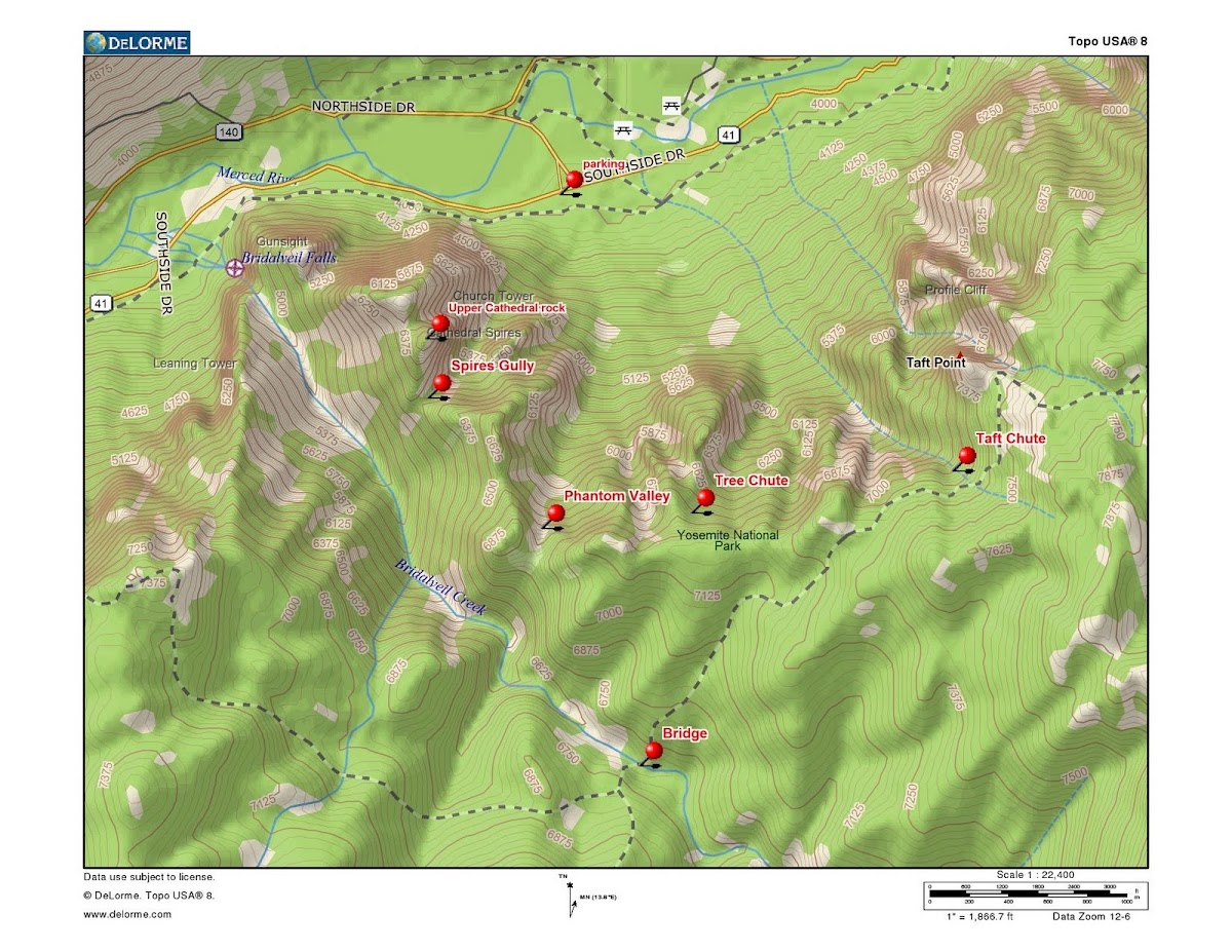
First let me say that if you just want great views, you can get similar ones on the Pohono Trail, from Inspiration Point to Sentinel Dome. The Four Mile Trail and Glacier Point also have some of the best views in the park. So this hike is for fun, more than photography. It will definitely avoid the crowds. Except for a few rock climbers, you won't see another person on this hike. You won't need any equipment. It's just talus-hopping and brush-walking. You can greatly reduce your effort if you look ahead and use good route finding skills. But you can also just bull your way through. Steve Hall recently mentioned that he has done Sierra Point, which is another fine abandoned trail. This hike is just like Sierra Point Trail, except that it lacks the (possibly) exposed-feeling place on that one. However, it is four times as high and will test your stamina. It makes a perfect hike to do on a short day, when you have to leave the valley to go somewhere in the late afternoon.

This hike is the climbers' descent route from Upper and Middle Cathedral Rock. You can get to the top of the gully via a long bushy ridge walk from the Bridalveil Creek bridge on the Pohono Trail, but as a hike this trail is usually done round trip from the valley. Here is a very old, low resolution photo of the route:

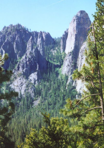
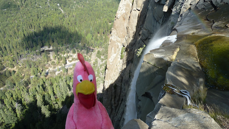
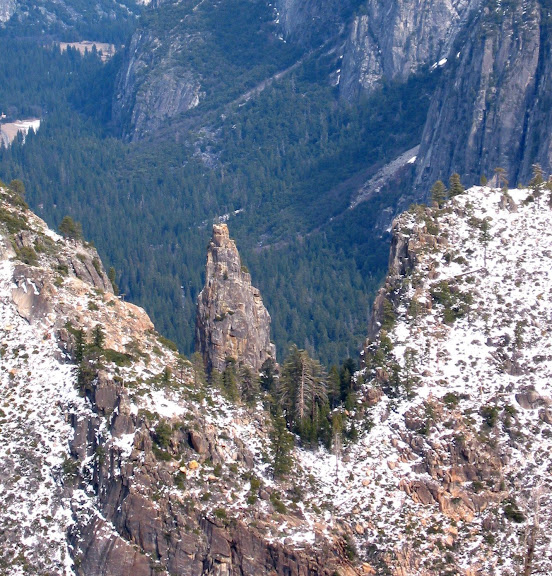
You can see Upper Cathedral Rock on the right, and the Cathedral Spires on the left of the gully. You can just see the ridge above Dewey Point peeking through the notch at the top of the gully. Here is a view of that notch taken from the Pohono Trail near Dewey Point:

That's Upper Cathedral Spire which you are seeing through the notch. Lower Cathedral Rock is on the left. Middle and Upper look fused from this vantage point, but it is actually difficult to get to the summit of the Middle rock...

Route Description

Park at the intersection of South Side Drive and the turnoff to El Cap Bridge. There is a well-beaten footpath that starts at this intersection and heads towards the rocks. It crosses the main valley foot trail and continues towards the gully. Climbers use this trail all the time, and it is easy to follow until you approach the base of Upper Cathedral Rock. From this point, numerous minor trails branch off the the starts of various climbs. You ascend anywhere in the gully, but there is a lot of tedious talus along the right hand side. The best trail stays towards the center of the gully in its top and bottom thirds and near the left side in the center section. When you pass the base of the spires, begin shifting back towards the center. There are ducks and cairns everywhere, so don't try to follow them all.

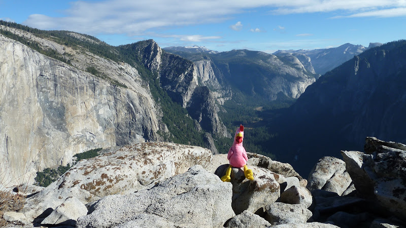
When you reach the top of the gully, don't scramble up towards the summit on the first slabs that you see . Continue through the notch and a short distance beyond, where you can turn right and ascend the ridge in steep but open terrain. If you continue downhill and to the right from the notch, you can beat your way to the creek, and (in very low water) walk all the way to the falls. Doing that and the summit would make for a very long day. Don't expect to do both.


Keep an eye on your route going up in this section, because it is easy to get too far to the left on the way back down.

You will find that the hike up is strenuous, but it's the hike back down that gets your legs. Also, be very careful of fallen leaves and loose dirt on the trail. Descend carefully. Good luck.
Re: Bushwhacks from Yosemite Valley to the South Rim: Cathedral Spires Gulley
October 20, 2010 09:12AM
Excellent post.

Does/has anyone get to this area by hiking in from the south, ala parking somewhere on the road like McGurk Meadows and then proceeding north? Seem like an obvious option because of the lack of climbing. I don't object to it, but my g/f has vertigo, and it makes going up things up bit dicey.
Re: Bushwhacks from Yosemite Valley to the South Rim: Cathedral Spires Gulley
October 20, 2010 02:21PM
Quote
tanngrisnir3
Excellent post.

Does/has anyone get to this area by hiking in from the south, ala parking somewhere on the road like McGurk Meadows and then proceeding north? Seem like an obvious option because of the lack of climbing. I don't object to it, but my g/f has vertigo, and it makes going up things up bit dicey.

Absolutely. I've done it many times from McGurk Meadow. I have someone drop me (us) off at the trail head and then proceed to the ridge, followed by a descent of one of the four gullies on this map. You could also go back to the trail head. The ridge between Taft Point and Cathedral Rock is a neat place. There are lots of great views on all sides.


Cross the Pohono Trail bridge over Bridalveil Creek and stay on the trail until it bends to the right. Go to the top of the ridge, and traverse as far to the left as you want. One comment about the terrain: This is not a forest grove. It has thin soil and burns from lightning every decade or so. Depending on how hot the fire was locally, you can get a complete cleansing and regrowth, or a soot-coated manzanita jungle gym. Here is an example from the Diving Board of what I mean:


It can be very hard to get through if you walk right into it. Look ahead and go around. As a general rule, it's easiest along the crest of the ridge and can be tough out on the open slopes. But remember that it is different every year. Sometimes it's no trouble at all. This is a lovely place when the Spring flowers are out.

I was thinking of posting another note about Phantom Valley, Tree Chute, and Taft Chute, if anyone is interested...
Re: Bushwhacks from Yosemite Valley to the South Rim: Cathedral Spires Gulley
October 20, 2010 02:44PM
I've always been interested in Tree Chute (and how navigable it is) and Phantom Valley, esp. in regards to pics.
avatar Re: Bushwhacks from Yosemite Valley to the South Rim: Cathedral Spires Gulley
October 20, 2010 06:13PM
I'm thinking your enticing me to do this sooner rather than later...
since I've mentioned this to you a couple of times...
May play hookey next week and just do it...

I think you probably also know I really want any info you got on any other routes you enjoy.
Is there a railing at Old Insp? Kudos on that shot of Silver Strand btw... gotta get there
in early spring now myself...

Thanks!
Re: Bushwhacks from Yosemite Valley to the South Rim: Cathedral Spires Gulley
October 20, 2010 09:26PM
Quote
bill-e-g
I'm thinking your enticing me to do this sooner rather than later...
since I've mentioned this to you a couple of times...
May play hookey next week and just do it...

I think you probably also know I really want any info you got on any other routes you enjoy.
Is there a railing at Old Insp? Kudos on that shot of Silver Strand btw... gotta get there
in early spring now myself...

Thanks!

There is no railing, though there must have been several once, and it's completely covered with awful brush. This is an exercise in picking the best route through a thicket. As I recall the best way leads somewhat to the right as you head out on the saddle connecting the point to the mountain.

To be honest, although my camera dating shows that the photo was made while I was at Old Inspiration Point, I did take photos from nearby it on the trek to and from the Phono Trail, and just east of there. I can't swear as to exactly where that view was taken. But if you go there, you should be able to figure it out...

The bushwhack down from the Pohono Trail to the point is completely obvious, if you know where the point is located (from the map).

The old books talk about tourists falling off the thing. It's easy to see when you are there how one could do that....
avatar Re: Bushwhacks from Yosemite Valley to the South Rim: Cathedral Spires Gulley
October 23, 2010 08:45AM
Window o opportunity there so we dood it.
Went up rock gullies entire way up to notch. Up to top of Upper Cathedral in < 2 hrs.
Then... fun fun... wack a doodle doo to top o Bridalveil.
Came back down trail which starts in earnest from near Upper Spires.
If you don't like shrub and probably cliffing out here and there and
nagivating a large number of waterfalls and getting scewered by
burned manzanita then you probably want to forgo Bridalveil.

Can say more if interest.


Chick-on is looking at you!
avatar Re: Bushwhacks from Yosemite Valley to the South Rim: Cathedral Spires Gulley
October 23, 2010 08:46AM
Top o da fall:


Chick-on is looking at you!
Re: Bushwhacks from Yosemite Valley to the South Rim: Cathedral Spires Gulley
October 23, 2010 09:04AM
Quote
chick-on
Top o da fall:


Awesome. I've never once before seen a pic from the edge of the falls, for whatever reason.
Re: Bushwhacks from Yosemite Valley to the South Rim: Cathedral Spires Gulley
October 23, 2010 09:20AM
One other thing: I've often heard that, once up there, ascending to the top of Middle C. is difficult (but it would offer the best view of El Cap for pics, most likely), but I've never heard exactly why. Is technical climbing necessary somewhere up close to the summit? Sort of looks like it from the angle of the shots here.
avatar Re: Bushwhacks from Yosemite Valley to the South Rim: Cathedral Spires Gulley
October 23, 2010 09:37AM
Just fine views of El Cap from Upper:


Chick-on is looking at you!
Re: Bushwhacks from Yosemite Valley to the South Rim: Cathedral Spires Gulley
October 23, 2010 12:24PM
I'm starting to get jealous of the places you've been that I haven't yet visited.

I suppose if/when I go there, I'll choose lower or upper and leave the middle one be.
Re: Bushwhacks from Yosemite Valley to the South Rim: Cathedral Spires Gulley
October 23, 2010 04:15PM
Quote
tanngrisnir3
One other thing: I've often heard that, once up there, ascending to the top of Middle C. is difficult (but it would offer the best view of El Cap for pics, most likely), but I've never heard exactly why. Is technical climbing necessary somewhere up close to the summit? Sort of looks like it from the angle of the shots here.

According to Roper's Guide, the notch between them is not technical climbing. I've done some of his "non-technical" routes, and don't always agree. In any case, I haven't tried it because the view would be almost the same and that's a very deep notch between Middle and Upper.
avatar Re: Bushwhacks from Yosemite Valley to the South Rim: Cathedral Spires Gulley
October 23, 2010 04:28PM
Getting from Upper to Middle looks doable... Didn't bother though since had sights on Bridalveil.

Put more photos with captions here:

http://picasaweb.google.com/yosemite.chick.on/Bridalveil

Enjoy
Re: Bushwhacks from Yosemite Valley to the South Rim: Cathedral Spires Gulley
October 24, 2010 09:22AM
Quote
bill-e-g
Getting from Upper to Middle looks doable... Didn't bother though since had sights on Bridalveil.

Put more photos with captions here:

http://picasaweb.google.com/yosemite.chick.on/Bridalveil

Enjoy
Awesome pics! How long did the whole trip take?
avatar Re: Bushwhacks from Yosemite Valley to the South Rim: Cathedral Spires Gulley
October 24, 2010 06:06PM
It was a dayhike. Billy had dinner with me in Manteca that evening.


Old Dude
avatar Re: Bushwhacks from Yosemite Valley to the South Rim: Cathedral Spires Gulley
October 24, 2010 10:04PM
Quote
hotrod4x5
Awesome pics! How long did the whole trip take?
Dayhike. Drive up ... hike... drive home...
Started hiking right about 8am. Back to car by 4pm.
Spent about 1/2 hr at the top of Upper Cath and about an
hour at the top of the fall.
I took my time, taking a lot of pictures. No idea if this is doing
it fast or not.

Going to the top of the fall and back from the notch is much
harder than just going to the top of Upper Cathedral. Much.
Can't stress this enough. It's a true bush whack, busting
thru manzanita and deadfall... esp. if you go up and down
directly from the notch. (I put one pict. of looking up at
where the notch is from just west of it... yummy)
Even when you get down to the creek.. it's a bunch of
cascades that you may or may not be able to navigate down.

Have fun
Re: Bushwhacks from Yosemite Valley to the South Rim: Cathedral Spires Gulley
October 25, 2010 12:30AM
Quote
bill-e-g

Going to the top of the fall and back from the notch is much
harder than just going to the top of Upper Cathedral. Much.
Can't stress this enough. It's a true bush whack, busting
thru manzanita and deadfall... esp. if you go up and down
directly from the notch. (I put one pict. of looking up at
where the notch is from just west of it... yummy)
Even when you get down to the creek.. it's a bunch of
cascades that you may or may not be able to navigate down.

Have fun

I've only done it in very low water, when you can just more or less step back and forth over the stream except at the actual drops. I don't think that the water is that low right now.

Also, I don't go straight down from the notch to the creek, but angle around a rock rib and down to the right. Some route finding might improve on your descent. I don't recall struggling with the manzanita in that area. But no matter how you do it, the climb back up to the notch in steep loose dirt is a grunt.

Of course, the brush changes from year to year. The last time I was there, I watched helicopters water bombing burning bush patches along the left side of the creek. After they quit, we went down to the falls, but had to walk through ashes in places.

I've been also through a manzanita thicket leading back up from the creek to the Gunsight descent that was among the worst that I have ever done. My shins were completely black and blue afterwards. But that was in 1963. It's doubtless burned and regrown a few times since then, so I don't know its current state....
Re: Bushwhacks from Yosemite Valley to the South Rim: Cathedral Spires Gulley
October 25, 2010 05:50AM
Quote
wherever
Quote
bill-e-g

Going to the top of the fall and back from the notch is much
harder than just going to the top of Upper Cathedral. Much.
Can't stress this enough. It's a true bush whack, busting
thru manzanita and deadfall... esp. if you go up and down
directly from the notch. (I put one pict. of looking up at
where the notch is from just west of it... yummy)
Even when you get down to the creek.. it's a bunch of
cascades that you may or may not be able to navigate down.

Have fun

I've only done it in very low water, when you can just more or less step back and forth over the stream except at the actual drops. I don't think that the water is that low right now.

Also, I don't go straight down from the notch to the creek, but angle around a rock rib and down to the right. Some route finding might improve on your descent. I don't recall struggling with the manzanita in that area. But no matter how you do it, the climb back up to the notch in steep loose dirt is a grunt.

Of course, the brush changes from year to year. The last time I was there, I watched helicopters water bombing burning bush patches along the left side of the creek. After they quit, we went down to the falls, but had to walk through ashes in places.

I've been also through a manzanita thicket leading back up from the creek to the Gunsight descent that was among the worst that I have ever done. My shins were completely black and blue afterwards. But that was in 1963. It's doubtless burned and regrown a few times since then, so I don't know its current state....

How about flat areas up there for camping, or any regulations that might apply up there? Sunrise on El Cap might make for interesting photography.
avatar Re: Bushwhacks from Yosemite Valley to the South Rim: Cathedral Spires Gulley
October 25, 2010 07:31AM
Yeah, I didn't go straight down or up to the notch.
Couple of pix on that set show the way I went.
Going down went to the north of that rock rib and then came
back angling almost in the middle of that rock rib to
the notch gully. Right now the notch gully is very overgrown.
If I did it again I would go the northern route.. really not
that much stuff to whack thru right now... but I didn't want
to sugar coat it... saying it was easy... and then someone
does it and screams bloody murder.

Agree on the stream... it's possible to make it down by
working around the cascades. I actually hiked back up in
the streambed, but going down was really unsure so angled
up higher and around. It's not a trivial walkdown.. just wanted
to make sure that was clear.

As for camping... there are a couple of spots up there (Upper Cath)
that are flat that you could sleep on. This is almost always the case
and it is there too.


Edited 1 time(s). Last edit at 10/25/2010 07:33AM by bill-e-g.
Sorry, only registered users may post in this forum.

Click here to login