Welcome! Log In Create A New Profile Recent Posts
Yosemite Valley

The Moon is Waxing Crescent (48% of Full)


Advanced

Re: Moran Point

All posts are those of the individual authors and the owner of this site does not endorse them. Content should be considered opinion and not fact until verified independently.

avatar Moran Point
June 12, 2011 08:24PM
avatar Re: Moran Point
June 12, 2011 08:28PM
We goez to Ostrander, Hart, and Edson. Climb up a couple of domes.
Funny thing... once we get on trail... wifey says "dang, the xcountry was easier!"

For fun I come down 4 Mile and get picked up below. After seeing the first 40 ppl
and telling 1/2 of them the trail is open to the top... was hoping that had to use the crampons.

Took too many photos ... will take a bit to put something together w/r to the other stuff.


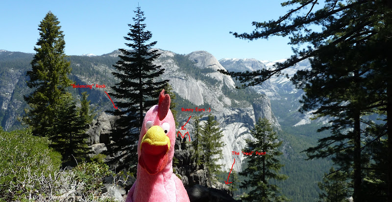
Chick-on is looking at you!
avatar Re: Moran Point
June 12, 2011 11:23PM
Quote
chick-on
Today:


If you go out all the way you can also see Nevada Falls:


Nice photos, but it appears that George Fiske's photo was taken a bit more to the right (south) of your photo. It looks like you are just a tad bit too north.

Also did you spot that unique balancing rock formation that's on the far left-hand side of Fiske's and Watkin's photo?


George Fiske's photo of Moran Point:
avatar Re: Moran Point
June 13, 2011 03:52AM
Where did you leave the trail to get there? Just down-trail from Union Point before the switchbacks start going down ( as I remember there's a long flat straight away before it starts going down ).
avatar Re: Moran Point
June 13, 2011 08:10AM
avatar Re: Moran Point
June 13, 2011 08:09AM
Uh... I dunno wedder to laugh or cry.

Do you want a photo a "bit south" of there? The first photo is almost identical.
Pretty good for how things are now if I don't say so myself. The trees grew a bunch
and make things a bit difficult to exactly duplicate that shot. (and I didn't
actually plan to go here so I didn't bring the photos with me)

Anyway, that "balancing rock" is a bit (ok, quite a bit) deceiving. The washed out
aspect of the photo hides the fact that it's not as impressive as it appears.
There is actually a small saddle and the rock is much wider than what you are thinking.
I actually climbed atop that rock and sat in the saddle.. and then proceeded
to climb all the way down to the point (which, if I really want to be a stickler...
you can't see in Fisk's photo).


For those who would like to see a few more:
https://picasaweb.google.com/yosemite.chick.on/Moran?authkey=Gv1sRgCPDD1Zu3jIaH6AE#5617716893710643986


Chick-on is looking at you!
avatar Re: Moran Point
June 13, 2011 11:33AM
Thanks for the links to the photographs.

Several more questions, if you don't mind.

Was there any sort of old trail you followed from the 4-mile trail to Moran Point? Or was it mostly, or all, cross-country?

What makes you believe that the true Moran Point is further out than what is depicted in the Watkins and Fiske's photos from Moran Point: topo maps, a USGS official marker at the true point, a guard-rail, or a sign indicating the actual Moran Point?

And finally, about that nice shot of Upper and Lower Yosemite Falls, was that taken at the actual Moran Point, or somewhere between Moran Point and the 4-Mile trail?

Again, thanks for resolving the mystery surrounding Moran Point. Good work.
avatar Re: Moran Point
June 13, 2011 02:02PM
Quote
plawrence
Was there any sort of old trail you followed from the 4-mile trail to Moran Point? Or was it mostly, or all, cross-country?
There wasn't any trail to speak of. A game trail perhaps. I saw deer tracks to the point area and bear scat below the "balancing" rock.
Although it was obvious that people had whacked thru the area in the past. The only trail section I thought
maybe was at the very end... maybe a little bit of rock work... but didn't take a picture of it. I didn't find any railing holes or markers.
I'll look at some docs I have ... but I don't recall ever seeing any bench markers mentioned anywhere.

Quote
plawrence
What makes you believe that the true Moran Point is further out than what is depicted in the Watkins and Fiske's photos from Moran Point: topo maps, a USGS official marker at the true point, a guard-rail, or a sign indicating the actual Moran Point?
Well, I was just nitpicking cause it seemed you were busting my balls on the shot.
I mean what is a "point"? Is it the very tip end that if you took one more step then you
would fall to your death? That is where I went to. But I would say the whole area with
the balancing rock and "bunny ears" rock are all Moran Point in a similar manner as the
large area where the snack shop is is Glacear Point. I thought it appropriate to mention
about Nevada Falls b/c that was a surprise to see.

Quote
plawrence
And finally, about that nice shot of Upper and Lower Yosemite Falls, was that taken at the actual Moran Point, or somewhere between Moran Point and the 4-Mile trail?
That was taken very close to where the end "point" is. Below almost everything you see in Fiske's photo.


Chick-on is looking at you!
Re: Moran Point
June 13, 2011 11:19AM
Awesome views! Another great place to visit in Yosemite. Thanks for sharing. I wish I were there right now!
avatar Re: Moran Point
June 13, 2011 11:26AM
OK, so the on straightaway downtrail from Union Point don't start down the hairpins, keep going straight following the contour line to the Point . . ?
Sounds pretty easy, DITTO on the thanks!
My Yosemite Bucket List is getting pretty big!


Edited 1 time(s). Last edit at 06/13/2011 11:26AM by qumqats.
avatar Re: Moran Point
June 13, 2011 01:54PM
Quote
qumqats
OK, so the on straightaway downtrail from Union Point don't start down the hairpins, keep going straight following the contour line to the Point . . ?
Correct. Very straightforward and very close to the turn.
If you want to get all the way out (where you can only go DOWN) then you have a bit of shrubbery dancing to do.


Chick-on is looking at you!
avatar Re: Moran Point
July 08, 2011 09:38AM
Quote
chick-on
Quote
qumqats

OK, so the on straightaway downtrail from Union Point don't start down the hairpins, keep going straight following the contour line to the Point . . ?

Correct. Very straightforward and very close to the turn.
If you want to get all the way out (where you can only go DOWN) then you have a bit of shrubbery dancing to do.


I was on the Four Mile Trail this past Wednesday (a bit late in the day to do too much off-trail exploring) but when I went to this spot on the trail, the grade of the mountainside seemed a bit too steep (slanted) to follow the elevation contour line towards Moran Point. Looking at the topography in person, it appears that the most logical spot to disembark the trail would be about 20-30 feet BEFORE the turn and start heading uphill, due east, about 30 to 50 feet in elevation gain and then proceed to follow the contour line of the slope. Is this correct? Or did just you just stay pretty much level in your cross-country hike and carefully traversed the steep slope (that's near the turn on the Four Mile Trail) to Moran Point?
avatar Re: Moran Point
July 10, 2011 09:32AM
I went to the turn and just kept going straight. Yes, it's steep... but it's dirt so it wasn't bad imo.
When I came back I did the same thing and hit the switchback on the button.
Hiking sticks can help...

The beauty of the Point IMO is that if you go ALL the way out you can see Nevada Falls.
But if you hesitate on the initial traverse I highly doubt you will want to do what is needed to
go all the way out there. Interestingly on my way out there (and beyond the "bunny ears" rock)
a bear decided to do it's business and left me a present...

There was another point MUCH higher up that looked interesting...


Chick-on is looking at you!
avatar Re: Moran Point
July 11, 2011 12:06AM
Quote
chick-on
I went to the turn and just kept going straight. Yes, it's steep... but it's dirt so it wasn't bad imo.
When I came back I did the same thing and hit the switchback on the button.
Hiking sticks can help...

I was just thinking that there should be an easier (less steep) path to take to Moran Point. I find it hard to believe the Fiske or Watkins would have traversed such a steep slope carrying photographic glass plates either on foot or by horseback or mule to Moran Point. I would think that following on or near the top of the ridge line that leads out to Moran Point could be easier. The exposure on the path you took looks pretty unforgiving if you happen to slip, and slide or tumble down that slope.

According to the old map (Revised Feb. 1954) that you posted in the earlier thread (and I have linked below), there was clearly a trail to Moran Point (which is probably overgrown with shrubs and brush by now). I doubt that the route you took to Moran Point (at least at that start) was ever a trail, or even a semblance of a trail. But unless the trail to Moran Point that was shown on that old map was pure fiction, there ought to be a less steep route to Moran Point (though now it might be covered by thick brush like the portion of the Old Four Mile Trail just below Union Point).


Quote
chick-on
The beauty of the Point IMO is that if you go ALL the way out you can see Nevada Falls.
But if you hesitate on the initial traverse I highly doubt you will want to do what is needed to
go all the way out there. Interestingly on my way out there (and beyond the "bunny ears" rock)
a bear decided to do it's business and left me a present...

There was another point MUCH higher up that looked interesting...


I think I know what point you're talking about. It looks quite interesting from the top of the Four Mile Trail. I think I took some photos of that point while hiking on the Four Mile Trail.
avatar Re: Moran Point
July 11, 2011 01:33AM
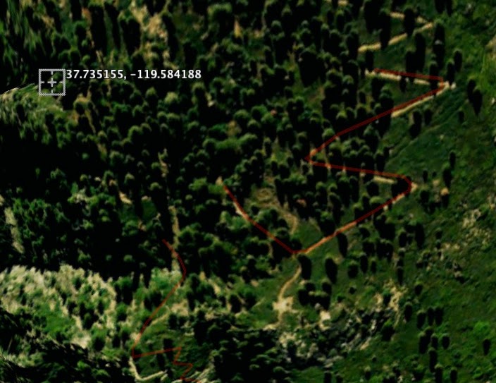
Something I noticed while futzing around with Google Earth and studying that 1954 map. If you carefully look at this 2009 image from Google Earth of the Four Mile Trail at the junction of the short Union Point spur trail, it appears that there's an old semblance of a trail rising above the Four Mile Trail at (or near) the junction with the Union Point spur trail.


The current Four Mile Trail in this image is highlighted in red. The Union Point spur trail is the short trail in the lower right quadrant (with that big patch of gravel/dirt where the old rest station was located). But if you look just above the junction of the Four Mile Trail with the Union Point spur, you'll notice what appears to be another possible trail that runs up the ridge a short ways then veers left towards Moran Point before disappearing in the brush and trees. Could this possibly be the start of the old trail to Moran Point?

If you go back to that 1954 map of area, the Four Mail Trail shown on it is the current Four Mile Trail (since the Four Mile Trail was rerouted in the 1930's), so the Moran Point trail shown on that map actually somewhat parallels the current Four Mile Trail near its beginning. And its beginning appears to be at (or near) the junction of the Four Mile Trail with the Union Point spur trail.

(The bull's-eye shown on the above image with its GPS coordinates is the approximate location of where Fiske and Watkins took their photos of Moran Point)


Edited 2 time(s). Last edit at 05/26/2014 09:47PM by plawrence.
avatar Re: Moran Point
July 11, 2011 08:25AM
I think that the GE drawing of the trail is a bit off. It should curve in there some.
Here is my GPS track. It did an amazing job of tracking:


Here is the switchback:

From that you can see the whole area is a whole lotta steep.
To make the relatively short path out to Moran Pt. area would take just more of the same.

Remember that people like Ansel went to places like The Diving Board to take pix. So getting to Moran is trivial in comparison.

After they close GP road in the fall I'll go up it again. I'll poke around some more. Check out Waterworks. Try to find any
semblance of a trail S of Union Pt. Jct.

We prob. need a 3rd party to take a look and give their opinion though. Where is basilbop? smiling smiley


Chick-on is looking at you!
avatar Re: Moran Point
July 11, 2011 09:09AM
The Four Mile Trail bend around the junction of the Union Point trail that's shown on Google Earth is how I remembered how it was last Wednesday (and how it's shown on detailed topo maps too). But you are correct that there was not a clear trail south of the junction at or near that point (that intersected with the Four Mile Trail), but such an old trail could have been covered by by the manzanita and other shrubs that were pretty thick right around the junction. (Note that the manzanita has done a very good job in obscuring the point where the Old Four Mile Trail arrives at Union Point.)

I also noticed on Wednesday about 40 to 50 feet up the slope above the Four Mile Trail (just slightly east of the junction with the Union Point spur trail) some sort of manmade installation covered by a giant square (10' x 10' ?) vertical black tarp -- a cellular antennae site perhaps? It is located within the trees that are above the Four Mile Trail at that location (but would be below that possible other trail shown on my Google Earth image).

And one last thing. Even if Fiske or Watkins got to Moran Point traveling cross-country (very well possible in the 1800's), that 1954 Yosemite map of the area clearly shows a trail to Moran Point. So where is the remnants of that trail today? The beginning of the cross country route you took from the Four Mile Trail to Moran Point doesn't appear to ever have been a trail. But according to that map, there once was a trail to Moran Point. So where was that trail located?


Edited 1 time(s). Last edit at 07/11/2011 09:12AM by plawrence.
avatar Re: Moran Point
July 11, 2011 11:37AM
Quote
plawrence
So where is the remnants of that trail today?
Buried under 50+ years o dirt?

I thought MAYBE I spied some old rock work VERY CLOSE to the VERY END of the point.
But... was too lazy to go down the 20 ft. or so to take a closer look.
Did not see any other markings or railings (unlike Pan. Pt. and Illioutte Overlook).


Chick-on is looking at you!
avatar Re: Moran Point
June 09, 2014 10:53AM
Quote
plawrence
... if you look just above the junction of the Four Mile Trail with the Union Point spur, you'll notice what appears to be another possible trail that runs up the ridge a short ways then veers left towards Moran Point before disappearing in the brush and trees. Could this possibly be the start of the old trail to Moran Point?
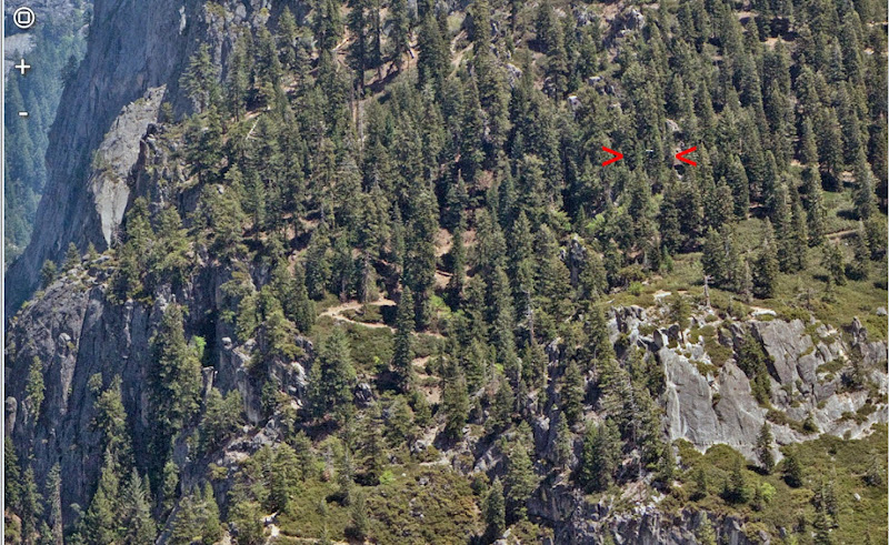
Since it seems to run almost directly toward the "mirror" (the large microwave reflector in that area), my guess would be that it's the trail they used (and probably beat) in the process of installing and maintaining the reflector. I didn't notice any sign of that trail when I was there the other day, but I did get more pics of the mirror that I'll post in the next day or two. It's even bigger than it looks in other pictures, and would have taken a fair amount of work to install.

Here's what I think is the location of the "mirror" (cropped from an xRez image from Eagle Point). The short horizontal line between the red markers is probably the top edge of the mirror:


That piece of trail that loops toward Moran Point out in the open is the S3 switchback. It's not S5, the one that gives scrambling access to Moran Point. That one's hidden in the trees.


Edited 1 time(s). Last edit at 06/09/2014 10:55AM by gophersnake.
avatar Re: Moran Point
June 09, 2014 10:10PM
Quote
gophersnake
... I did get more pics of the mirror that I'll post in the next day or two. It's even bigger than it looks in other pictures, and would have taken a fair amount of work to install.

I posted a little more here, including a pic of the mirror from above and behind.
avatar Re: Moran Point
May 26, 2014 02:39PM
Quote
chick-on
I went to the turn and just kept going straight. Yes, it's steep... but it's dirt so it wasn't bad imo.
When I came back I did the same thing and hit the switchback on the button.
Hiking sticks can help...

I've been thinking more about Moran Point lately, photographing it from the Valley floor, etc. A week and a half ago I happened to be in the area and took another look at the "S5" switchback (my own name for it -- the topmost switchback in the "Short" series, just below the Union Point junction).

Chick-on's route following the contours looked a bit scary to me. My interpretation of it is the one I've marked with a red arrow in the pic below. I had visions of not being able to maintain good traction in the loose dirt, slipping sideways, and not being able to get back up the slope gracefully. I felt more comfortable going more uphill at about 45° to it (green arrow) -- about halfway between the contour and the fall line.


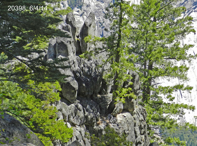
I found a few signs (such as manzanita skinned from being stepped on) that others had had the same idea. The going actually gets easier after the first 50 feet or so, and before long I was unmistakably on the "land end" of Moran Point. I was interested in getting a look at the "bunny ears" and I did, but only from a safe distance this time:


Later I may try getting closer. I'm especially interested in which parts of the Valley are visible from the bunny ears (so I know where I have to go to see the bunny ears from below).

The next day I did prowl the valley looking for good views of Moran Point. It's visible from Stoneman Meadow and Stoneman Bridge, but pretty much end-on so it's a bit hard to recognize unless I already know what I'm looking for. I've taken lots of pics of that area from Ahwahnee Meadow but this time the light happened to be just right and... eye popping smiley could those be the bunny ears?


I've also been studying the feature that chick-on calls "the false Moran". I don't ever expect to get to it -- it looks pretty darn unreachable -- but by now I have lots of pics of it from all angles. I'll post some eventually, when I haven't anything better to do. tongue sticking out smiley
avatar Re: Moran Point
May 27, 2014 06:20AM
Kewl. The old trail itself goes around to the north of the bunny ears.

Back in March the wife and I did up 4 Mile and down Panny. (yeah, it's been that kind of year)
The False Moran is much much lower than Moran. You are well above it
by the time you make the turn below Union where the gate is. Unfortunately there are
loads of trees in the way and it's hard to get a good view of it from there. Much lower below
there are nice views of it. It will take a lot of effort and daring doo to get out there..

Here's faux toe took then of Moran from up the hill from Ahwahnee:


Have fun


Chick-on is looking at you!
avatar Re: Moran Point
May 28, 2014 05:03PM
Quote
chick-on
Here's faux toe took then of Moran from up the hill from Ahwahnee...

From somewhere on that big talus pile, then? As I mentioned, I've been looking for viewpoints but it never occurred to me to try going up there. You're chick-on whereas I'm chick-en. winking smiley


The above pic was taken from the switchback I call "L19" -- the one sort of fenced in by a pile of big rocks that reminds me of a fort, with a dropoff just beyond that you don't see unless you climb up among the rocks. That snag shows up in my pics from Ahwahnee Meadow, right where I'd expect it.


That same switchback is where I first noticed "False Moran" from, only I started calling it "Tower Point" (and still do).
avatar Re: Moran Point
June 09, 2014 10:49PM
I did go back to Moran last week, and this time I got out beyond the bunny ears. I'm still not 100% sure I was looking at the backs of the right rocks but I think I see a few points of similarity. Here's a "front" view of the bunny ears, to start with:


I tried working my way around to the left side of Moran. The choices seemed to be between wading through a lot of manzanita or getting uncomfortably close to the edge. I found a short Y-shaped bare-dirt chute where I went down one branch of the Y and up the other, trying to avoid the stem of the Y (which seemed to lead over the side). On the way back, I chose the manzanita instead.

I soon found the same old stone steps that chick-on posted the picture of...


...and later, on my way back, a few more above them:


The farther I went around the bunny ears, the more different they looked. Here they're still pretty recognizable...


...but are these the same rocks? I'm going to be trying to match them up detail for detail with the other, more familiar looking pictures.


Chick-on's "looking down on Moran (from just south)" picture, here, helps. When I blow it up, I think I see some familiar-looking rocks toward the upper left.

Anyway, by then I was far enough out to see Nevada Fall:

avatar Re: Moran Point
July 08, 2011 09:46AM
Quote
rightstar76
Awesome views! Another great place to visit in Yosemite. Thanks for sharing. I wish I were there right now!

Looks like a really great view, but while on the Four Mile Trail last Wednesday, I found a very similar view (but more wide open) of Half Dome, Tenaya Canyon and North Dome on the Four Mile Trail itself a bit further downhill past a gate, almost at the junction with the Old Four Mile Trail below Union Point. So while I do want to head out to Moran Point for curiosity and historically purposes, for taking photos of this view, this spot on the Four Mile Trail might be sufficient, if not superior, to the historical Moran Point as seen in those classic photos.

(When I have some more time, I'll post a photo from this spot on the Four Mile Trail.)
avatar Re: Moran Point
August 25, 2012 02:03PM
Here's a nice photo of Moran Point from another angle that I found today while surfing the web.

The photo was taken by Wes Wang who lives in Southern California. A very nice profile shot of Moran Point with Half Dome in the background:


http://www.trekearth.com/gallery/North_America/United_States/West/California/Yosemite_National_Park/photo291059.htm

.
avatar Re: Moran Point
September 06, 2012 07:44AM
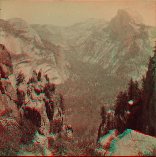
I'm not entirely convinced that is truely Moran. Now you give me something else to do.

Here's an old stereograph of Moran View from Z Old Trail made into 3D Anaglyph:


For fun here's Vernal too:


Will have to go search for this pointy rock in the picture when searching for middle section
of Old Four Mile Trail this fall. smiling smiley

Have fun


Chick-on is looking at you!


Edited 1 time(s). Last edit at 09/06/2012 07:45AM by chick-on.
avatar Re: Moran Point
November 27, 2012 10:33AM
Forgot about this until was walking back to 4 Mile TH last weekend and looked up:


Although the photo by Wes is indeed very nice. It's not Moran Pt.


Chick-on is looking at you!
avatar Re: Moran Point
November 27, 2012 04:34PM
Thanks for the clarification and photo.

By your estimation, looking at your photo do you think that maybe there could be a direct route (obviously NOT a former trail) from the valley floor up to Moran Point. Looking at your photo, it appears there could be (but might involve a huge amount of bushwhacking) but I've never really explored that area of the Valley's south wall to see if there's any passible cross-country route up to Moran Point and beyond.
.
avatar Re: Moran Point
November 27, 2012 09:28PM
Maybe I'm not clear. But this:
http://yosemitenews.info/forum/read.php?3,38632,61140#msg-61140
and this:
http://yosemitenews.info/forum/read.php?3,38632,59018#msg-59018
Are of the same pointy rocks. And both are NOT Moran Pt.
To be specific. I'm almost certain that those pointy rocks are here

From Moran Pt. you can see Nevada Falls. You cannot see Nevada from
the trail ... so that is why you may want to head out there. Obviously you're doing it at your own risk.

To get to Moran straight from the valley.
Uh. I think you are misjudging just how steep it is.


Chick-on is looking at you!
avatar Re: Moran Point
November 27, 2012 10:13PM
Thanks for the additional clarification. That point (which isn't Moran Point) is at about 5,760' according to the topo map. But looking at your photo, it looked like it might have been posible to zig-zag up that broad gully and craggy cliff wall to that unnamed point.
.
avatar Re: Moran Point
November 27, 2012 10:19PM
And by any chance, in your vast photo collection do you have any close-up photos of Moran Point from the valley floor similar to the one you took of this unnamed point?

If you do, I would like to see how the real Moran Point looks when someone looks up towards it from the valley floor.
.
avatar Re: Moran Point
November 28, 2012 07:59AM
From Stoneman or Ahwahnee Meadows are good views. Or take the trail from
Ahwahnee Mdw towards Lower Yosemite Falls... it climbs a bit and has nice
views. I only have the big picture shots from lots of places. No super zoom of Moran.
Ahwahnee is probably one of the nicer views since you aren't looking at it straight on
like at Stoneman:


From near Gov. Stable area (Indian Canyon TH area) :


From Union follow the ridge diagonally to the left and you'd run into those "pointy" rocks, the false Moran.

If you take the picture east to Half Dome where 4 Mile makes the turn and the gate is near Union...
you are looking at the north wall of Moran...


Chick-on is looking at you!
avatar Re: Moran Point
November 28, 2012 11:05AM
Thank you for those photos from the valley floor. It helps answer another question I had about Moran Point, that one cannot see it from the traverse of Four Mile Trail (between Glacier Point and the start of the switchbacks). The point you see from the traverse appears to be the higher of three points (which Moran Point is part of).

Quote
chick-on

If you take the picture east to Half Dome where 4 Mile makes the turn and the gate is near Union...
you are looking at the north wall of Moran...


Here's a photo from that spot. So what I marked as Moran Point is Moran Point or just the north wall leading further out to Moran Point?
avatar Re: Moran Point
November 28, 2012 09:29PM
Purty much that is Moran Pt.


Chick-on is looking at you!
avatar Re: Moran Point
November 28, 2012 11:50PM
Thanks for the confirmation.
avatar Re: Moran Point
November 28, 2012 09:38PM
Here's another I took from Eagle Peak which shows the trail clearly.
False Moran was nicely lit at the time was up there.


Chick-on is looking at you!
avatar Re: Moran Point
June 23, 2013 09:57PM
I took some pics from Ahwahnee Meadow a week or two ago. First the big view to establish the approximate location (though I did move around while taking the others):


Now the detail views:


I've always been curious where the webcam is located that takes those Ahwahnee-Meadow-and-Half-Dome shots, so while I was there I did some nosing around:


avatar Re: Moran Point
November 28, 2012 03:53PM
Hi folks, new here. I love these discussions of lost geographical features!

I was on the Upper Yosemite Falls Trail in early October taking pictures of the Four Mile Trail and vicinity. I'm going to attach a few I happened to get of the Union, Moran, and Glacier Points area. Maybe they'll be relevant to this discussion.


The first two were taken from Columbia Rock, the other two from the spur trail above Lower Yosemite Fall. They all looked kind of blue-hazy (like the third one or worse) so I Photoshopped all but the third one to remove most of the cyan and blue. That makes them look almost monochrome so I cranked up what little color was left. That's why the chartreuse vegetation. winking smiley

I'm not a hundred percent sure what I'm looking at except for Glacier Point (in three of the four). I think I know which one is Union Point but I'd welcome a second opinion anyway.


Edited 1 time(s). Last edit at 11/28/2012 04:07PM by gophersnake.
avatar Re: Moran Point
November 28, 2012 06:50PM
Quote
gophersnake
Hi folks, new here. I love these discussions of lost geographical features!

I was on the Upper Yosemite Falls Trail in early October taking pictures of the Four Mile Trail and vicinity. I'm going to attach a few I happened to get of the Union, Moran, and Glacier Points area. Maybe they'll be relevant to this discussion.


The first two were taken from Columbia Rock, the other two from the spur trail above Lower Yosemite Fall. They all looked kind of blue-hazy (like the third one or worse) so I Photoshopped all but the third one to remove most of the cyan and blue. That makes them look almost monochrome so I cranked up what little color was left. That's why the chartreuse vegetation. winking smiley

I'm not a hundred percent sure what I'm looking at except for Glacier Point (in three of the four). I think I know which one is Union Point but I'd welcome a second opinion anyway.

Thanks for posting the photos. I added a bit more contrast, sharpness and saturation to the photos to make it easier to view the features.

Yes, on the top three photos Glacier Point is clearly visible. On the top and third from the top photos, Union Point is also visible.

And I'm guessing (not 100% sure) that the north wall of Moran Point is visible in the top three photos.
(But I'm sure our pink bird Chick-on is looking at you! can correct me if I'm off-base on that).


I do have a question about the third photo on the top for anyone who might know:


Is what I circled switchbacks of a trail?

And if so, are the top part of the switchbacks part of the current Four Mile Trail or are they the part of the old Four Mile Trail. The reason I ask is because I thought the current switchbacks on the top were slightly further to the west so that the western turns of those switchbacks had a clear view of the western portion of Yosemite Valley.

.
avatar Re: Moran Point
November 28, 2012 08:51PM
Ooh, I like your restored-color versions! What did you use, if you don't mind telling?

Here's what I thought was Union Point, maybe even with Agassiz Column peeking through the trees to the left of center. I left the haze in place this time. You seem to do a better job of enhancing than I do.


I didn't think those markings you circled were switchbacks. I remember the real switchbacks as being a bit farther right (west). I know I have some pics (whether mine or Google's) with those switchbacks clearly showing. I'll look for them a little later.
avatar Re: Moran Point
November 29, 2012 12:08AM
Quote
gophersnake

Ooh, I like your restored-color versions! What did you use, if you don't mind telling?


I just used Photoshop Elements to adjust the contrast, levels and sharpness.


Quote
gophersnake

Here's what I thought was Union Point, maybe even with Agassiz Column peeking through the trees to the left of center. I left the haze in place this time. You seem to do a better job of enhancing than I do.


Yes, that appears to be Union Point with Agassiz Column partially hidden by the trees.
.
avatar Re: Moran Point
November 28, 2012 09:21PM
Here's a Google satellite view of the real switchbacks. Since this is equivalent to a map, north is at the top. All the other pics were taken looking southeast. I locate Union Point by the little sand-colored bare spot left of center -- where the building used to be, as I understand it:


And here's a blowup of the area you circled. I figure it's somewhere toward the top of the satellite view.


Edited 1 time(s). Last edit at 11/28/2012 09:26PM by gophersnake.
avatar Re: Moran Point
November 28, 2012 09:35PM
The trail looks more or less like this:


I also drew in in dots the old trail portion by the traverse. Don't count switchbacks though. I just v. crudely drew in a trail.


Chick-on is looking at you!
avatar Re: Moran Point
November 28, 2012 11:58PM
Quote
chick-on
The trail looks more or less like this:


I also drew in in dots the old trail portion by the traverse. Don't count switchbacks though. I just v. crudely drew in a trail.


Could what looks like a trail with switchbacks above the traverse be the trail that connects the Four Mile Trail with Sentinel Dome?

.
avatar Re: Moran Point
November 29, 2012 01:36AM
Quote
plawrence
Could what looks like a trail with switchbacks above the traverse be the trail that connects the Four Mile Trail with Sentinel Dome?
I doubt it very much. The Four Mile Trail first switchbacks its way up to about 7000, then levels off and continues on to Glacier Point barely climbing. At Glacier Point it connects to the Pohono Trail which climbs gently toward Sentinel Dome. A shortcut from the Four Mile to the Pohono would have needed some serious switchbacks wherever it was located. It wouldn't have made much sense to duplicate the ones already in place above Union Point.

This is cropped from NPS's Glacier Point Area Hiking Map, http://www.nps.gov/yose/planyourvisit/upload/glacierhikes.pdf


And this is from a topo of the same area at mappingsupport.com

avatar Re: Moran Point
November 29, 2012 02:32AM
While I'm playing with maps, here's a moderately clumsy overlay, chick-on's GPS track on topo:


Here's an even clumsier one, satellite view on topo:


And here's the same satellite view that I used for the overlay, all by itself for comparison:


...whereupon the gophersnake slithers off to bed so he can take care of biz in the morning, go out and make some money, and be able to buy the gasoline, trail mix and Nuun tabs for his next season of Yosemite trips.
avatar Re: Moran Point
November 29, 2012 02:59AM
The gophersnake springs out of bed remembering he meant to check out the switchback from which the pink chicken set off on his Moran Point exploit. Forgot to mention: I'm the kind of geek who catalogs switchbacks.

It turns out to be the one just below Union Point (which I call S5 for reasons I'll explain eventually) Here are the three views I have of it. How it looks as you're approaching it from below:


How it looks when you're standing in the point looking at both trail segments:


And how it looks when you're approaching it on the way down:


'Night all!
avatar Re: Moran Point
November 29, 2012 06:49AM
I have a feeling you haven't seen this other thread:
http://yosemitenews.info/forum/read.php?3,47695,47695#msg-47695

And here's the actual gps track in
Gmap4 Sat View
(you can zoom in more) (it's a really good track) smiling smiley
or
Gmap4 Topo4 View

or simply


(overlaying maps is kinda fun though) wink

Have fun


Chick-on is looking at you!
avatar Re: Moran Point
December 01, 2012 02:37AM
Quote
chick-on
I have a feeling you haven't seen this other thread:
http://yosemitenews.info/forum/read.php?3,47695,47695#msg-47695

I hadn't -- only the one that started out on the Old Big Oak Flat road but became about Moran Point, Agassiz Column, and stuff: http://yosemitenews.info/forum/read.php?3,46585,46585#msg-46585

Thanks for that!
avatar Re: Moran Point
December 01, 2012 04:00AM
Why do they call it Moran Point? Do morans go there?

avatar Re: Moran Point
December 01, 2012 05:04PM
Wutt


Maybe it got something to do with glacial moraines.


Chick-on is looking at you!
avatar Re: Moran Point
December 03, 2012 04:56PM
What came first the chick-on or the egg? Or the Moran protester or the chick-on Moran Point protester?
Re: Moran Point
May 28, 2014 03:54PM
Probably got it's name from this guy: Re: Eeeeks recent posting.
avatar Re: Moran Point
May 28, 2014 04:33PM
Quote
Torero14
Probably got it's name from this guy: Re: Eeeeks recent posting.

Yes, Moran apparently made it halfway famous by drawing or painting some of his Yosemite scenes from there.
Quote
Richard J. Hartesveldt

MORAN POINT is located on the south valley wall just east from Union Point. It was named for the famed painter of western scenes, Thomas Moran."
-- Yosemite Valley Place Names (1955)

That's probably why Fiske referred to it as "Moran's Point," here.
avatar Re: Moran Point
November 29, 2012 03:18AM
Quote
gophersnake
Quote
plawrence

Could what looks like a trail with switchbacks above the traverse be the trail that connects the Four Mile Trail with Sentinel Dome?

I doubt it very much. The Four Mile Trail first switchbacks its way up to about 7000, then levels off and continues on to Glacier Point barely climbing. At Glacier Point it connects to the Pohono Trail which climbs gently toward Sentinel Dome. A shortcut from the Four Mile to the Pohono would have needed some serious switchbacks wherever it was located. It wouldn't have made much sense to duplicate the ones already in place above Union Point.


I was actually referring to this old trail that connects the Four Mile Trail with Sentinel Dome as it was still shown on this 1970 USGS topo map of Yosemite Valley:

avatar Re: Moran Point
November 29, 2012 07:02AM
You cannot see the upper section of trail above the traverse in that photo.
Maybe you are just seeing light shining on granite. The old trail is visible
somewhat from the traverse itself You can hike up or down the bottom maybe
4 switchbacks... ymmv... but above that for all the way to the Sentinel Dome
Trail you will be very hard pressed to find anything else. (I've looked multiple
times now... the last being last Saturday)... other than the bottom portion near
the current 4 Mile Trail I've only found 1 definitive spot where the trail def. was.


Chick-on is looking at you!
Re: Moran Point
November 30, 2012 07:13PM
OK, I just had to weigh in. This thread started as being about Moran Point. Chick-On's map shows its location very well:


and plawrence commented about the "balancing rock"
Quote
plawrence
Also did you spot that unique balancing rock formation that's on the far left-hand side of Fiske's and Watkin's photo?

George Fiske's photo of Moran Point:
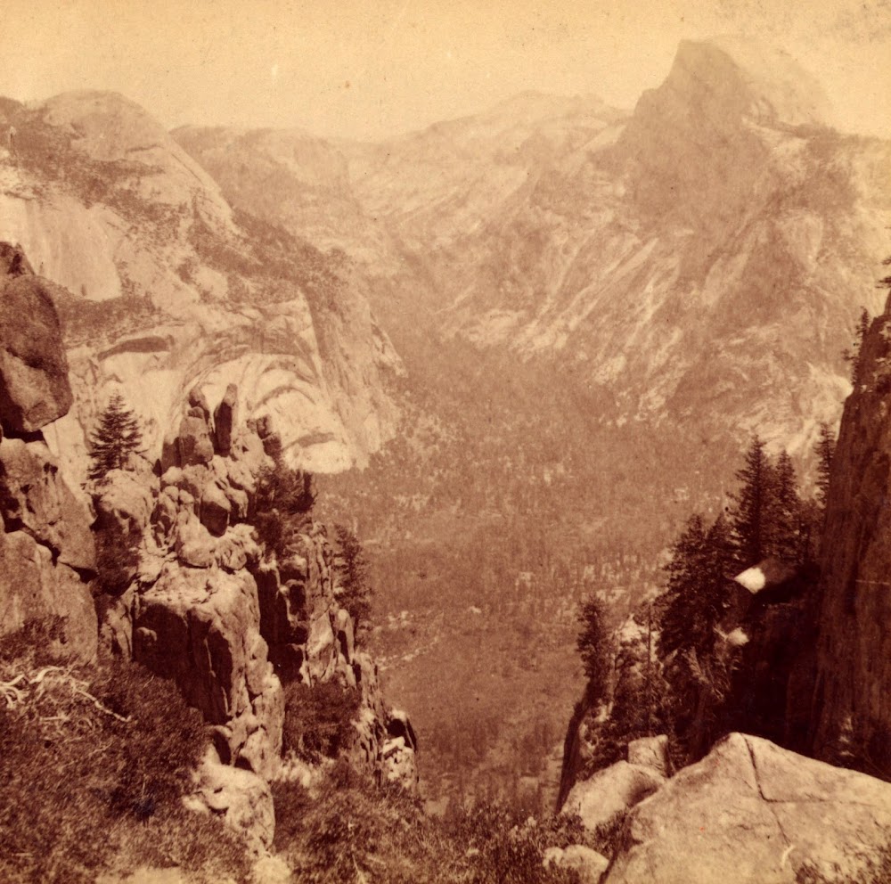
It's not as much of a balancing rock as you might think. Here is a view of it from the back side, taken at Halloween of last year:


Here is another of the 100+ year old photos of Moran Point, with a little better exposure. There is no balancing rock:


The old trail ended at the point where the above photo was taken.

The actual lookout at Moran Point is on a ledge below the rabbit ears rock. My buddy, who climbs at every opportunity, went there the hard way:


But a spur of the Moran Point Trail goes down to that lookout by passing along along the back side of all those rocks. It's a bit overgrown, but the stone steps are still there. You can see them in this photo:


Like so many of the old lookouts, the view is obstructed by a couple of young trees. In the good old days, the rangers would have fixed that....

Alas, we were there in late afternoon, and the foreground was in deep shadow, while the background was in brilliant sunshine. The only photos worth taking were of distant objects whose views were very like those you can more easily get from the Four Mile Trail:


Still, if you like a bit of historical poking around, Moran Point is any easy place to do it.
avatar Re: Moran Point
November 30, 2012 08:27PM
Your buddy is on the steps I drew in here:
http://yosemitenews.info/forum/read.php?3,47695,47900#msg-47900

Thanks for sharing the additional photos.

I won't mention it yet again... but if one goes way out there on Moran one can get a
nice view of Nevada Falls. And there is a nice flat spot to hang out on complete with
a backrest. (It's the photo in the first post)

Have fun


Chick-on is looking at you!


Edited 1 time(s). Last edit at 11/30/2012 08:29PM by chick-on.
Re: Moran Point
December 01, 2012 03:41PM
Quote
plawrence
I was actually referring to this old trail that connects the Four Mile Trail with Sentinel Dome as it was still shown on this 1970 USGS topo map of Yosemite Valley:


Yes that old connecting spur is where your arrows point, but I'll bet that most our your readers saw only the much more prominent wilderness boundary and power line that run more or less on top of it...

Below, I have outlined the old trail spur in blue, from where it leaves the Sentinal Dome Trail to where it hits the Four Mile Trail:
avatar Re: Moran Point
December 04, 2012 05:38PM
Quote
plawrence
I was actually referring to this old trail that connects the Four Mile Trail with Sentinel Dome as it was still shown on this 1970 USGS topo map of Yosemite Valley:

Oh, that trail! Sorry. sad smiley

Thanks for the reminder, though. I've been curious about the history of the "infrastructure" in that area anyway, but so far I haven't found anything about it in these forums. I think I'll start a new thread about it.
Sorry, only registered users may post in this forum.

Click here to login