
According to the wilderness permit office on Tuesday, the latest report on Friday the week prior was that there were a few spots around Moose Lake clear of snow, and at the visitor center at Lodgepole the board claimed 20% coverage between Pear and Moose. In fact, snow was basically a non-issue for our trip--the few places we did cross snowfields were easily avoided for the snow-adverse. Moose Lake was essentially clear of snow, and coverage between it and Pear was maybe 5%, probably less. On the other hand, the mosquitoes were quite bad around 10,000', mostly in the basin south of Moose Lake and the meadows between Moose and Pear.
At Panther Gap, we encountered a group of three hikers also going to Moose Lake. We met up with them again in Alta Meadow, where they asked if they could hike with us to the lake, where they were going to meet up with another group already there, since we were familiar with the route. However, they quickly decided they wanted to head straight for the ridge instead of dropping into the meadow. We never saw them again.
On the topo map the Alta Meadow trail continues to the east edge of the meadow, but the trail is just a faint track past the small stream and campsites at the upper, west end of the meadow. Due to the wet winter, there was a great wildflower display in the meadows, especially for August.

From Alta Meadow the trail to Moose Lake hasn't been maintained in years, and it is even more faint. It seems to die for good in "Last Chance Meadow", the second creek encountered after leaving Alta Meadow.

However, past "Last Chance" it reappears as a sandy gully and climbs just west of the creek and trees to the east of the meadow. The steep trail is quite rutted here, and there is evidence of old "water bars" built to control the erosion. This trail fades out at the top of the ridge, where it overlooks the two small lakes to the south of Moose Lake. From the top of the ridge, the path heads west--staying just south of the talus--to a well-ducked "gap" where the trail crosses the ridge and drops into the basin south of Moose Lake. From here, the path is mostly obvious and well-ducked to the south shore of Moose Lake.
We did hear a few shouts for the party we had left in Alta Meadow, but didn't see them--or anyone else--at Moose Lake. We did have some company at camp, however.

Although the day had been clear, the winds were blowing smoke from a nearby fire towards the Great Western Divide, slowly obscuring the vistas.

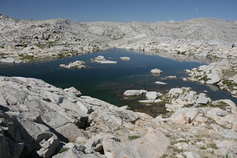
From Moose to Pear, the route is mostly easy cross-country travel with several beautiful lakes and meadows along the way. The most difficult part is perhaps the final drop into Pear Lake.

A solitary dead tree serves as a landmark along this route--we stayed to the south of it, but there are many possible routes between Moose and Pear. There is a use trail in the "Green Mile"--a grassy slot that eventually drops into Pear Lake.
Just before Emerald Lake, we passed the first people we had seen since Alta Meadow; Pear Lake had been vacant.
Here is a GPS track of the cross-country section of the trip. From Alta Meadow to Moose Lake, with a few minor deviations, this route follows the old unmaintained trail:

More Pictures


