Welcome! Log In Create A New Profile Recent Posts
Pothole Dome (Tuolumne Meadows, Yosemite National Park)

The Moon is Waxing Gibbous (61% of Full)


Advanced

Re: Inspiration Ridge, Mt. Beatitude, Hill's Point, and Artist Creek (part 2)

All posts are those of the individual authors and the owner of this site does not endorse them. Content should be considered opinion and not fact until verified independently.

Inspiration Ridge, Mt. Beatitude, Hill's Point, and Artist Creek (part 2)
October 31, 2011 05:19PM
Mount Beatitude. There is a real one in the Holy Land somewhere, but in Yosemite it refers to the first view of Yosemite Valley by the white men of the Mariposa Battalion when they arrived in 1851 to chase Indians. Lafayette Bunnell named the place where he first saw the valley "Mount Beatitude" for the great emotion he felt at the time. Actually, he didn't refer to a specific point, but to the "plateau" that ran along the valley rim in that area.

What came to be called the Mariposa Trail was a piece of the Indian trail that ran in the heights to the south of the valley. Coming down from the east side of Tenaya Lake and passing east of Glacier Point, it reached Bridalveil Creek near the current campground. There it split. Branches ran southwest towards Wawona via Alder Creek or west to Chinquapin via Indian Creek. The branch which was used as the south entrance to Yosemite Valley ran towards Badger Pass, and then more or less where our hike went as far as !st Saddle, then down Meadow Brook to the top of Silver Strand Falls, where it turned west. Below that point, it is now called "The Pohono Trail".

As Bunnell recalls it, 29 years later (see book: Discovery of the Yosemite)

"To obtain a more distinct and quiet view, I had left the
trail and my horse and wallowed through the snow alone to
a projecting granite rock. So interested was I in the scene
before me, that I did not observe that my comrades had all
moved on, and that I would soon be left indeed alone. My
situation attracted the attention of Major Savage, who
was riding in rear of column, who hailed me from the
trail below with, "you had better wake up from that dream
up there, or you may lose your hair; I have no faith in
Ten-ie-ya's statement that there are no Indians about here.
"

In later years he always stated that the first full view of the valley was from Old Inspiration Point, but I can assure you that nobody "wallows" down to Old Inspiration Point (It's too far below the trail), and nobody calls up to there from any trail. And there are no actual lookout spots up the hill on the south side of the trail.

On the map below I have placed an X where the real Mt. Beatitude must be. It is very close to the current trail, and could have been right next to the Indian foot trail. Moreover, the trail is descending rapidly at that point, so Major Savage could have been below that point on the trail and still have seen it and called up to it.
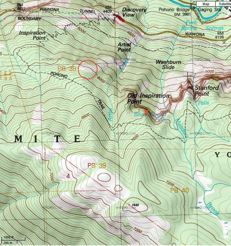


I have also placed a circle on the map where Hill's Point must be.

When you get there, Mount Beatitude has a great, unobstructed view of the valley and a superb view of Silver Strand Falls. It's not bushy, at least not at the point. But the reason that the guides didn't take people there is that the view of Bridalveil Falls is obstructed by the flank of Stanford Point. That's a deal breaker for tourists with cameras (See typical group with cameras, below). So the guides didn't take people there and the name didn't stick.


When you get to Mount Beatitude, there is a fine, unobstructed place to sit and take in the view.


And this is the view:


The lighting isn't very good on an October afternoon, but you can see how this first view of the valley would have impressed Bunnell. It also explains why his memoir is ecstatic about the view of El Capitan, but doesn't mention the waterfalls. He couldn't see Bridaveil. He could, however, have had a great view of Silver Strand Falls, since he was there during the snow melt....if he had been willing to go right to the edge on snow and ice.


Mount Beatitude is worth a visit, if you are going by on the Pohono Trail. You can hike down directly from above it on the trail, but it's also easy to traverse in from the west, where the trail is more at that level. It's a lot easier to get to than Old Inspiration Point, now that the trail to the latter is gone.

Now to Hill's Point. In 1865, there was no Wawona Road, so this section was still called the Mariposa Trail. An artist or photographer would have needed his horse and a mule or pack horse to carry all the gear. This is not a small painting, and the almost photographic accuracy suggests that he could have used a wet plate camera to capture the scene. That's what landscape painters do today. On the other hand the magnitude of effort needed for photography in 1865 was enormous (you actually had to make the emulsion on-site), and there is no record of him selling any photos from this era. Plus, that's not what Hudson River School painters did. I think that he camped at Hill's Point for a few days while he roughed in the painting, then took it to a studio somewhere to finish up. At that time he would have put in the fake foreground. Don't be upset by that. They all did it. Especially when the scene is from a promontory, and there isn't any foreground. Thomas Ayres made the first image of Yosemite Valley on June 27, 1855. Here is his sketch, made somewhere near New Inspiration Point. Note the fake foreground:


Here is Thomas Hills's famous painting from ten years later:


So we hiked on the trail to the west side of Artist Creek, then cut downhill until we got to the computed place. Amazingly, there was another fantastic promontory. Not only does it have unobstructed views, but it has a modest dip on its uphill side, with a sandy flat spot for a tent and another one for the horses. And no hint that anyone has been there for generations. The lead-in from the trail above isn't too steep for horses to traverse, especially if you come in from the west side, where the trail is only two hundred vertical feet above it. Or you could just walk in from the trail on the 6000 foot contour.


I'll call it Hill's Point.

Actually, if you want to be picky, a close comparison with the painting suggests that it was painted two hundred feet to the east and a hundred feet lower. But this certainly is the place to camp or to take photographs. We did hike east and down to take a look for the precise spot, but we were seduced by a class A deer trail and went a hundred feet too far east and too far down (You can't always see out through the trees). It was now bushy between us and the magic spot. Maybe another time. I recommend just visiting the promontory. The view from there is just as good, and you won't ever have anyone saying, "Oh I have a photo from that spot".

Now it was time to go back up to the trail. But my buddy began whining about too much uphill (after his run up the Four Mile Trail. The kid is only 60...he should be able to do that sort of thing!). He insisted that we just go down alongside Artist Creek. OK. We hadn't scouted that out beforehand, but I didn't care, so long as he was willing to come back up if it gets cliff-like down below. Well, of course it soon did.


It looked just as bad to the left. That's Artist Creek over there, and the buttress beyond it has an adequate veneer of dirt and trees. But how to get there? Mr. Grumpy had to lead us back up to where the creek could be crossed, and we then went down the east bank without any trouble.

Hill's Point. N37.7090, W119.6815 elev 6020.
Mount Beatitude. N37.7029, W119.6301 elev 6840. Remember that with cliffs around, GPS readings will wander.

Here is Google Earth's take on things:
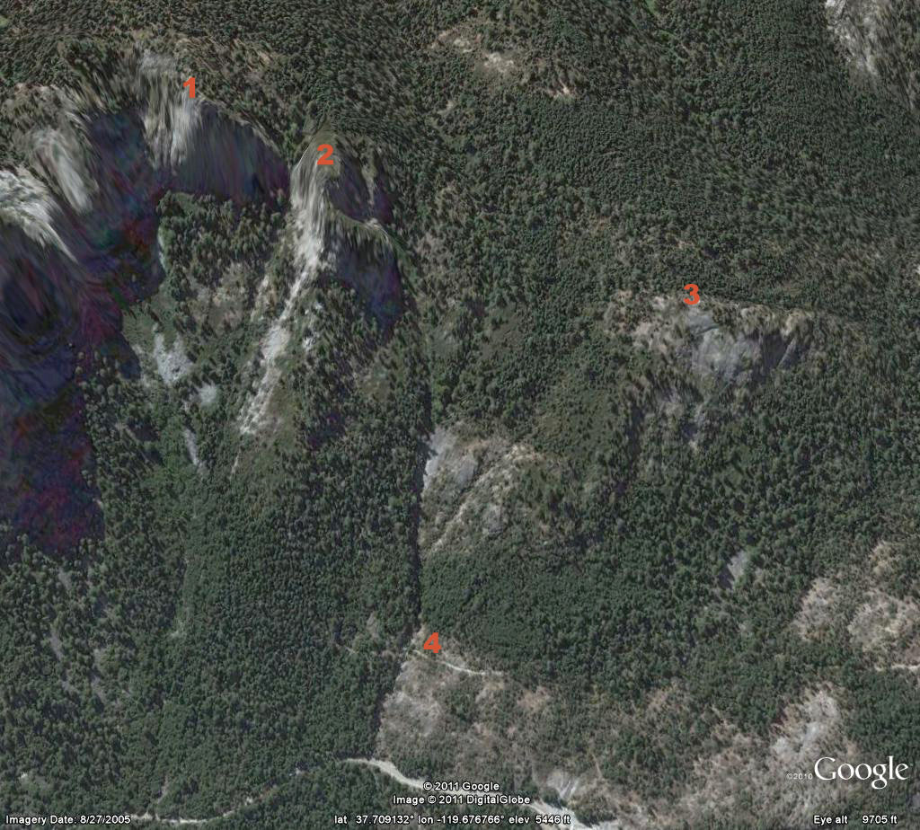

1 is Mount Beatitude. 2 is Old Inspiration Point. 3 is Hill's Point. 4 is Artist Point on the Old Wawona Road. The current highway is visible below.

It would have been helpful to have looked at this view before heading down the hill towards the creek...


Edited 4 time(s). Last edit at 04/16/2013 07:50PM by wherever.
avatar Re: Inspiration Ridge, Mt. Beatitude, Hill's Point, and Artist Creek (part 2)
October 31, 2011 06:14PM
My apologies... but awesome again.

And hope you don't mind... but here is Old Inspiration Pt.:


And this shows a little bit of the area:
http://yosemitenews.info/forum/read.php?3,29227,29248#msg-29248
and
http://yosemitenews.info/forum/read.php?3,29227,29233#msg-29233

Not sure I understand the reason behind the Yosemite Falls old photo...

Tanks again


Chick-on is looking at you!
Re: Inspiration Ridge, Mt. Beatitude, Hill's Point, and Artist Creek (part 2)
October 31, 2011 07:05PM
Quote
chick-on
Not sure I understand the reason behind the Yosemite Falls old photo...

It was meant to show why people wouldn't want to be guided to Mt. Beatitude...It's because the camera nuts wouldn't get to record Bridalveil Falls. I didn't have a picture of camera nuts on Old Inspiration Point, but there probably is one somewhere. Sorry.

Come to think of it, that may still be true.
avatar Re: Inspiration Ridge, Mt. Beatitude, Hill's Point, and Artist Creek (part 2)
October 31, 2011 06:55PM
Nice pictures. I think the "Hill's Point" one is particularly cool.
avatar Re: Inspiration Ridge, Mt. Beatitude, Hill's Point, and Artist Creek (part 2)
October 31, 2011 09:04PM
Quote
wherever

Here is Thomas Hills's famous painting from ten years later:


So we hiked on the trail to the west side of Artist Creek, then cut downhill until we got to the computed place. Amazingly, there was another fantastic promontory. Not only does it have unobstructed views, but it has a modest dip on its uphill side, with a sandy flat spot for a tent and another one for the horses. And no hint that anyone has been there for generations. The lead-in from the trail above isn't too steep for horses to traverse, especially if you come in from the west side, where the trail is only two hundred vertical feet above it. Or you could just walk in from the trail on the 6000 foot contour.


I'll call it Hill's Point.

Actually, if you want to be picky, a close comparison with the painting suggests that it was painted two hundred feet to the east and a hundred feet lower. But this certainly is the place to camp or to take photographs. We did hike east and down to take a look for the precise spot, but we were seduced by a class A deer trail and went a hundred feet too far east and too far down (You can't always see out through the trees). It was now bushy between us and the magic spot. Maybe another time. I recommend just visiting the promontory. The view from there is just as good, and you won't ever have anyone saying, "Oh I have a photo from that spot".


Thanks for the great writeup. It's wonderful that you took the time to explore all this and then write it all up.

Just one remark regarding Hill's Point.

Comparing Hill's painting with your photo, I think Hill's actual spot might have been HIGHER (not lower) than the promontory where you took the photo. I base this on the relationship of Middle Cathedral Rock with Sentinel Rock and Sentinel Dome. In Hill's painting, Middle Cathedral Rock is shown clearly BELOW Sentinel Dome and slightly BELOW the highest point of Sentinel Rock. But in your photo, Middle Cathedral Rock is HIGHER than Sentinel Rock and almost inline with the top of Sentinel Dome. That suggests that Hill might have sketched his painting at an elevation HIGHER (not lower) than the elevation of the promontory where you took your photo.


Re: Inspiration Ridge, Mt. Beatitude, Hill's Point, and Artist Creek (part 2)
October 31, 2011 09:40PM
Quote
plawrence
Comparing Hill's painting with your photo, I think Hill's actual spot might have been HIGHER (not lower) than the promontory where you took the photo. I base this on the relationship of Middle Cathedral Rock with Sentinel Rock and Sentinel Dome. In Hill's painting, Middle Cathedral Rock is shown clearly BELOW Sentinel Dome and slightly BELOW the highest point of Sentinel Rock. But in your photo, Middle Cathedral Rock is HIGHER than Sentinel Rock and almost inline with the top of Sentinel Dome. That suggests that Hill might have sketched his painting at an elevation HIGHER (not lower) than the elevation of the promontory where you took your photo.


Grump. You are absolutely right, because that's the wrong photo. Remember, I said that we went a bit too far down the hill, looking for the magic point? The above photo is what we got there. Here is the photo that's actually from Hill's Point:


This is the one from the point, and which is about a hundred feet too high, and also too far west.

Still, I'm glad that someone looks at these details.
avatar Re: Inspiration Ridge, Mt. Beatitude, Hill's Point, and Artist Creek (part 2)
October 31, 2011 10:10PM
The next time you (or anyone for that matter) are in Wawona... Go into the Hill Studio building
and check out the incredible paintings in there. This gem is HUGE. Maybe 8'x10'.
Look familiar?


Unfortunately I didn't take a closeup of the name... but I think it did say Mt. Beatitude
to which I thought... hmm... (or something similar).

So I wouldn't get too worked up on it's 20 ft. higher or lower. Peter is a stickler for details...
(but I'm still waiting for 'when I have time I'll post more pictures' and his UP Eagle Creek trek)
(let's see if he wants to not step on shrubbery after that baby! wink )


Chick-on is looking at you!
avatar Re: Inspiration Ridge, Mt. Beatitude, Hill's Point, and Artist Creek (part 2)
October 31, 2011 10:20PM
Quote
chick-on

So I wouldn't get too worked up on it's 20 ft. higher or lower. Peter is a stickler for details...
(but I'm still waiting for 'when I have time I'll post more pictures' and his UP Eagle Creek trek)
(let's see if he wants to not step on shrubbery after that baby! wink )

I'll post more of my photos soon enough. I'm just not that organized with my photos as you are. But they'll appear soon enough. wink

(I do appreciate that you'll still interested in them. )


Re: Inspiration Ridge, Mt. Beatitude, Hill's Point, and Artist Creek (part 2)
November 29, 2011 05:18PM
Are these paintings for sale? I'm thinking about trying to get my corporate office to spring for something like this.
Re: Inspiration Ridge, Mt. Beatitude, Hill's Point, and Artist Creek (part 2)
November 29, 2011 07:32PM
Quote
chicagocwright
Are these paintings for sale? I'm thinking about trying to get my corporate office to spring for something like this.

You can buy reproductions. The originals are priceless, and all in museums...

The NY Historical Society owns the one I cited at the top of this thread. I don't know if they sell copies of that one, but they have a nice reproduction of the Donner Lake painting by Bierstadt for $2500. Or $4500 framed...
avatar Re: Inspiration Ridge, Mt. Beatitude, Hill's Point, and Artist Creek (part 2)
October 31, 2011 10:11PM
Excellent!

I think this promontory is almost a near match when it comes to the elevation. I don't think the actual spot of Hill's vantage point was that much lower than from this promontory. On thing I did notice in Hill's painting (but this could just be artistic license on Hill's part) is that in Hill's painting the lowest of the Three Brothers is clearly shown just beyond El Capitan which suggest Hill's vantage point might have been further to the east than the promontory. On the other hand, the amount of the face of Half Dome that is shown plus how North Dome is lined up with El Capitan in Hill's painting suggests he might have sketched parts of the painting from a vantage point further WEST of the promontory.


Re: Inspiration Ridge, Mt. Beatitude, Hill's Point, and Artist Creek (part 2)
November 01, 2011 07:00PM
A huge thank-you to all of you who take the time to post these photos, provide the co-ordinates and do the research to get all the historical references in as well! I, too, am WAY behind in sorting through my off-the-beaten-track photos and writing up the corresponding hikes (although I've yet to get quite as far off as some of the places you all have checked out) but hope to get some stuff posted sooner rather than later.

Between the places mentioned in this thread and all the stuff off the 4-mile alone, my to-do list seems to get longer with every thread on this board! eye popping smiley It looks like my relocation to the west coast will still be another year or so out but, once I'm living within driving distance of Yosemite, I've got some serious catching up to do!
avatar Re: Inspiration Ridge, Mt. Beatitude, Hill's Point, and Artist Creek (part 2)
November 29, 2011 08:13AM
I have "The Yosemite Grant 1864-1906 - A Pictorial History".
In there is a map drawn by none other than John Muir

From west to east:
New Inspiration Pt.
Mt. Beatitude
Inspiration Pt.
Standpoint of Silence
Meadow Brook

The ridge above... which includes those above all the way to Dewey
is marked as: Topinemete Bluffs

So, remember that what you called Hill's Pt... that drawing by Hill
(which he called Mt. Beatitude) ... well... that IS Mt. Beatitude.
And what you are calling Mt. Beatitude. That has to be Standpoint of Silence.


Chick-on is looking at you!
Re: Inspiration Ridge, Mt. Beatitude, Hill's Point, and Artist Creek (part 2)
November 29, 2011 08:26AM
Quote
chick-on
I have "The Yosemite Grant 1864-1906 - A Pictorial History".
In there is a map drawn by none other than John Muir

From west to east:
New Inspiration Pt.
Mt. Beatitude
Inspiration Pt.
Standpoint of Silence
Meadow Brook

The ridge above... which includes those above all the way to Dewey
is marked as: Topinemete Bluffs

So, remember that what you called Hill's Pt... that drawing by Hill
(which he called Mt. Beatitude) ... well... that IS Mt. Beatitude.


And what you are calling Mt. Beatitude. That has to be Standpoint of Silence.

That's interesting. Muir would know. I have seen the Standpoint of Silence labelled as being elsewhere, but have already noted that people are very sloppy about these things. So, that means that the old Mariposa Trail was downhill a bit from the current Pohono Trail.

A couple of further comments. The 1911 topo shows that the trail actually went right to the Standpoint of Silence, or whatever, before it went to the spur trail over to Old Inspiration Point.
see http://yosemitenews.info/forum/read.php?3,39035,39070#msg-39070

Also, that makes it even more amazing that what I called Hill's Point shows no sign that anyone has been there. It really does look untouched. Totally forgotten by modern man...
avatar Re: Inspiration Ridge, Mt. Beatitude, Hill's Point, and Artist Creek (part 2)
November 29, 2011 08:46AM
My chick-on brain figured out how to show you:


But then again... looking at it ... it's not real clear, is it?


Chick-on is looking at you!
Re: Inspiration Ridge, Mt. Beatitude, Hill's Point, and Artist Creek (part 2)
November 29, 2011 02:08PM
Quote
chick-on
My chick-on brain figured out how to show you:


But then again... looking at it ... it's not real clear, is it?

Yes, it is obscure. This is based on the old map that has Meadow Brook without its bend to the left at the end, so it is shown as going over the cliffs in the wrong place (It actually becomes Silver Strand Falls). But remember that Mt Beatitude was named at the time of the first sighting of the valley, but wasn't really described by Bunnell in any detail at the time. Thirty years later he wrote something down, but it's clear this his memory is vague. So again, it turns out to be whatever the guides were telling people at the time that Muir or anyone else did that trail for their first time.

But....here is a real surprise. I have just now come upon the Spring 1998 copy of Yosemite Magazine, where a scholar has looked at old diary entries and at some research by William Hood (He and his wife made the old trail map overlay that we have been using) which was kept in the Yosemite Library. This suggests that they entered the valley by following a track through the snow made by non-combatant Indians that was way below the "Mariposa Trail" Which is ironic, since the Mariposa
Trail was named the Mariposa Trail because people thought that they had used the higher (summer) Indian Trail into the valley. Anyway, he thinks that they came up from Grouse Creek to New Inspiration Point, and saw the valley from there. If so, nobody, including Bunnell, described it correctly. It's a neat article, which can be found here:
http://www.yosemite.ca.us/library/yosemite/60-2.pdf

Anyway, I'll stick with the name of Hill's Point. As for what I had been calling Mt. Beatitude, it could be called the Standpoint of Silence, but I know of at least two other places that have been called that. The names wander from one generation to the next, at least until they get on the USGS maps.


Edited 1 time(s). Last edit at 11/29/2011 02:12PM by wherever.
avatar Re: Inspiration Ridge, Mt. Beatitude, Hill's Point, and Artist Creek (part 2)
November 29, 2011 02:39PM
Ok. The only kicker for me ... is that right on Hill's Paintings... he calls it Mt. Beatitude.
I think we both want to get the name correct and consistent. With varied accounts and
crude maps it just adds to the confusion at times. A wonderful example of this type
of thing is Panorama Pt.
Another interesting item I ran across yesterday (thanks to you and the Wawona Tunnel)..
is that Tunnel View used to be called Inspiration Pt.... and the entire area
where you park ... that is fill from the excavation of the tunnel.


Chick-on is looking at you!
Re: Inspiration Ridge, Mt. Beatitude, Hill's Point, and Artist Creek (part 2)
November 29, 2011 07:28PM
Quote
chick-on
Ok. The only kicker for me ... is that right on Hill's Paintings... he calls it Mt. Beatitude.
I think we both want to get the name correct and consistent. With varied accounts and
crude maps it just adds to the confusion at times. A wonderful example of this type
of thing is Panorama Pt.
Another interesting item I ran across yesterday (thanks to you and the Wawona Tunnel)..
is that Tunnel View used to be called Inspiration Pt.... and the entire area
where you park ... that is fill from the excavation of the tunnel.

You can't make it consistent, because they all disagree. The painting that you photographed in Hill's studio was made at Old Inspiration Point, as your photo proves. Hutchins 1870 guide book (on-line text is here:link, or a gigantic pdf with all the pictures is here: link) is very clear that Mt. Beatitude is 300 feet lower than Inspiration Point and comes first on the trail up from the valley. But he thinks that Mt Beatitude is at 6900 feet and Inspiration Point is at 7200 feet. This would put Inspiration Point up at Dewey Point (unlikely), or he thinks Mt Beatitude and Old Inspiration Point are just reversed from what I been calling it. Of course, he does exaggerate the heights of things, but Hill's Point is way down at 6000 feet. Here is what he says about coming down the trail from the direction of Wawona (This was before the Wawona Road existed, so he would be on the Mariposa Trail):

As you now descend, the dark purple haze at your right reveals
a near approach to the goal of your anticipations, the Mecca of
this pilgrimage. Almost before the gratifying fact is realized, you
have reached " Inspiration Point," and are standing out upon a
bold promontory of rock, and with feelings all your own, are
looking over the precipice of nearly three thousand feet, into the
deep abyss. This is the first view obtained of Yo-Semite Yalley.
Mr. Sidney Andrews, in his correspondence to the Boston Adver-
tiser, thus writes of this glorious scene* :

" Suddenly as I rode along, I heard a shout. I knew the
valley had revealed itcelf to those who were at the front of the line.
I turned my head away I couldn't look until I had tied my horse.
Then I walked down to the ledge and crawled out upon the over-
hanging rocks. I believe some men walk out there, it's a dull
clod of a soul who can do that. In all my life, let it lead me where
it may, I think I shall see nothing else so grand, so awful, so sub-
lime, so beautiful, beautiful with a beauty not of this earth, as
that Vision of the Yalley. It was only yesterday evening, I can-
not write of it yet. How long I sat there on the rocks I never
shall know. I brought the picture away with me ; I have only to
shut my eyes and I see it as I saw it in that hour of hours. I
think I shall see nothing else so sublime and beautiful, till, hap-
pily, I stand within the gates of the Heavenly City."

As you are now some eight and a half miles from the hotel, how-
ever enchanting this spot may be, you must not linger here too
long ; but, bringing lunch, after you are rested, pay it another visit
from the valley, and make a day of it. Besides, a really finer view
than this is obtained a short distance below, on " Mount Beati-
tude," from whence a more comprehensive picture of the valley is
realized. To see this, however, will require a short detour from
the trail, and a little more time.

Presuming that you could not resist the temptation of witness-
ing the imposing view from Mount Beatitude and knowing the
impossibility of even approximating justice in any written descrip-
tion you will think of it as you descend the mountain, and dream
of it both by day and by night. Presently you come to the " Hermit-
age," a hollow sugar-pine tree that was the home of a solitary
woodsman for nearly three months.


He also describes a trip up from the valley:

RIDE TO MOUNT BEATITUDE AND INSPIRATION POINT.

It is especially desirable that those
who have accompanied us thus far by Big Oak Flat, and who,
from whatever cause, prefer returning the same way, should be
with us on this trip. For if possibly we exclude the scene from
" Glacial Point," or from the summit of the " Three Brothers,"
there is nothing in this world known to man that can equal the
views from "Mount Beatitude" and "Inspiration Point." If,
however, it has been determined to return via the Mariposa grove
of big trees and Mariposa, and we emphatically hope that it has,
inasmuch as all tourists who can, should arrive one way and
depart the other, these glorious sights can be witnessed on the
route homeward,. without an especial visit.
...
Up, up we climb, bench after bench, stretch after stretch, with
fine views all the way, until at last, we arrive at the turning off
place for Mount Beatitude." Let us now tie our horses, and
while they rest, walk out about one hundred and fifty yards to the
wonderful sight.
...
Remember we are standing on a precipice of nearly three
thousand feet. The whole valley and its surroundings are unrolled
before us like a map. The river below is as a ribbon of silver,
seen only at intervals, winding among the trees ; the trees resem-
bling mere shrubs. The grand old sides, and proud head, of
Tu-tock-ah-nu-lah loom grandly up. Ditto the " South Dome,"
and the " Clouds Best," and the " Sentinel Dome," and the
" Sentinel," with any number of others. In the distance are many
snow-covered peaks of the sierras, visible almost to their culmina-
ting crest. In the foreground, on our left, is the " Ribbon Fall,"
three thousand three hundred feet above the valley ; on our right
is the Pohono, or Bridal Yeil Fall," nine hundred and forty
feet. Above and back of that stands the " Three Graces," three
thousand six hundred feet high. If the storm has been gathering,
perhaps we can see it swoop down " on the wings of the wind,"
and drape the whole landscape in cloud. At times the entire
valley is filled with them, piled layer above layer, stratum above
stratum, to the very tops of the mountains, their edges sufficiently
light to allow the granite walls to be dimly revealed.

Inspiration Point stands out and up at a somewhat greater
altitude than Mount Beatitude, but although the view of the distant
sierras is more comprehensive, that of the valley is more limited.
The general characteristics of both being similar there is no neces-
sity for any further remarks. Therefore let us enjoy the scene in
peaceful reflection, and when we can say " enough," let us depart
on our winding way, and dream of that we have seen.


OK, now it sounds like he just has Old Inspiration Point and Mt Beatutude reversed. Or else, he thinks Hill's Point is Mt Beatitude and the elevations are much exaggerated. But then Hill is wrong about the label on the painting you saw. I can cite many other examples of this confusion, but this is already much more than you wanted to know. We can quit trying to sort it out.
avatar Re: Inspiration Ridge, Mt. Beatitude, Hill's Point, and Artist Creek (part 2)
November 29, 2011 08:27PM
From that description the map from Muir sounds correct.. and, again,
I take the stance that "Hill's Point" is Mt. Beatitude.
And much further up... Inspiration Pt. (now Old Inspiration Pt.).
IMHO Hill's painting depicts "Hill's Point" and is Mt. Beatitude.
It seems clear from the description to me... and makes sense...
Mt. Beatitude IS just off the trail... and one could call up from there.
Maybe I'm just being a Dodo Bird though.

Regardless, thanks for the investigatory work.


Chick-on is looking at you!
Re: Inspiration Ridge, Mt. Beatitude, Hill's Point, and Artist Creek (part 2)
November 29, 2011 09:04PM
Quote
chick-on
From that description the map from Muir sounds correct.. and, again,
I take the stance that "Hill's Point" is Mt. Beatitude.
And much further up... Inspiration Pt. (now Old Inspiration Pt.).
IMHO Hill's painting depicts "Hill's Point" and is Mt. Beatitude.
It seems clear from the description to me... and makes sense...
Mt. Beatitude IS just off the trail... and one could call up from there.
Maybe I'm just being a Dodo Bird though.

Regardless, thanks for the investigatory work.

Well, no. First, the Major called up to Bunnell on Mt Beatitude. You cannot possibly call up to Hill's Point or Old Inspiration Point from below. In deep snow. You could possibly call up to the other one, as I argued, but probably not. So all that stuff in the Yosemite Magazine about them taking a much lower track, and Mt Beatitude really being near New Inspiration Point is probably right. Assuming, of course, that Bunnell named it on that day, so by definition it has to be somewhere that he went then. If it's not the place named by Bunnell, then it's just a matter of who you define as being right instead.

My old professor believed that only nutcases argued about definitions. You can argue about history, though...
avatar Re: Inspiration Ridge, Mt. Beatitude, Hill's Point, and Artist Creek (part 2)
November 29, 2011 10:52PM
What exactly is the definition of up? wink

But, I would argue that you can call up to Old Inspiration Pt. from the trail...
although I don't think that is going to help my case.

Here's OIP from the trail:


Quote
wherever
So all that stuff in the Yosemite Magazine about them taking a much lower track, and Mt Beatitude really
being near New Inspiration Point is probably right.
Isn't this what I keep saying? (i.e. Muir's crude map of sequence of features is correct)

In all honesty I think your map above... 1 - that should be CALLED Mt. Beatitude... but with Hill's paintings and Muir's map...
I'm not buying it.
1 - Standpoint of Silence
2 - Old Inspiration
3 - Mt. Beatitude
The photo I posted of Hill's. That is def. not view from Old Inspiration Pt.

Anyway, I keep saying the same thing. As do you. Probably should agree to disagree on this one.


Chick-on is looking at you!
Re: Inspiration Ridge, Mt. Beatitude, Hill's Point, and Artist Creek (part 2)
November 29, 2011 11:08PM
Quote
chick-on
Anyway, I keep saying the same thing. As do you. Probably should agree to disagree on this one.

Nah. I'll concede. Now that I think about it, Juliet was right. A rose by any other name, and all that. Don't care.

But which route the Mariposa gang used to enter the valley, that's worth some research.
avatar Re: Inspiration Ridge, Mt. Beatitude, Hill's Point, and Artist Creek (part 2)
November 30, 2011 06:54AM
Quote
wherever
Quote
chick-on
Anyway, I keep saying the same thing. As do you. Probably should agree to disagree on this one.

Nah. I'll concede. Now that I think about it, Juliet was right. A rose by any other name, and all that. Don't care.

But which route the Mariposa gang used to enter the valley, that's worth some research.

O Chick-on where art thou?

"I'm up here on Old Inspiration Pt. silly."

"You had better wake up from that dream up there, or you may lose your crown; I have no faith in
Old Dude's statement that there are no Marmuts about here"

.....

Well... um. The reason for caring is obviously if the names are determined... then the history can be possibly interpreted.
Unfortunately they didn't have digital cameras and a nutjob like me running around taking ten thousand pix.
And accounts are like fishermen at times...

The whole thing came about because, as you may know, I've been looking for all the sides of
The Yosemite Grant (and found one up on Insp. Ridge btw)... and I keep seeing slightly different
maps of what exactly were the grant boundaries.... then remembered I had that book... and there was
that picture (which of course had yet another take on the boundary (proposed by Muir))...
and thought you would be interested.

Anywho... not trying to offend, annoy, or otherwise.

On the original route in... to me ... (and it's been awhile since read the book... or looked at that)...
just thinking... the route that makes the most sense on horses pretty much would be
the route of the Old Wawona road from Grouse Creek... which would take you right to
New Inspiration Pt.


Chick-on is looking at you!
Re: Inspiration Ridge, Mt. Beatitude, Hill's Point, and Artist Creek (part 2)
November 30, 2011 08:18AM
Quote
chick-on
The whole thing came about because, as you may know, I've been looking for all the sides of
The Yosemite Grant (and found one up on Insp. Ridge btw)... and I keep seeing slightly different
maps of what exactly were the grant boundaries.... then remembered I had that book... and there was
that picture (which of course had yet another take on the boundary (proposed by Muir))...
and thought you would be interested.

I'll have to wake up and start looking for those things. Is it an iron disk, a stone cairn, or a tin square up in a tree?
avatar Re: Inspiration Ridge, Mt. Beatitude, Hill's Point, and Artist Creek (part 2)
November 30, 2011 03:16PM
Quote
wherever
I'll have to wake up and start looking for those things. Is it an iron disk, a stone cairn, or a tin square up in a tree?
Well... I can't tell you how many times I've missed stuff like this. (I'm hoping I missed some since there are two corners on Indian Ridge!)
There is probable cairn... and two tin squares... as in:


Chick-on is looking at you!
Re: Inspiration Ridge, Mt. Beatitude, Hill's Point, and Artist Creek (part 2)
November 30, 2011 04:23PM
Thanks for the photo. But I'd guess that the tree isn't long for this world. It has a big reddish growth on it that is a sure sign of incipient decay....
avatar Re: Inspiration Ridge, Mt. Beatitude, Hill's Point, and Artist Creek (part 2)
November 30, 2011 12:04AM
Quote
chick-on

1 - Standpoint of Silence
2 - Old Inspiration
3 - Mt. Beatitude

I think the above is probably the best guess based on Muir's map and Hill's painting.

A couple of things I would like to note about the description of where Mt. Beatitude is located. Hutchins and another account I've read have stated that Mt. Beatitude was about 150 yards from the trail.

Also Hutchins describes a hollowed sugar pine tree, named the "Hermitage" being located near Mt. Beatitude. Do you think this hallowed sugar pine might still be standing after all these years? If so, that sugar pine tree could serve as a landmark to determine which point is the true Mt. Beatitude described by Hutchins and others.


avatar Re: Inspiration Ridge, Mt. Beatitude, Hill's Point, and Artist Creek (part 2)
January 03, 2012 07:09AM
OK. I'll admit when I'm wrong.
Hill's Point it is.

http://www.yosemite.ca.us/library/yosemite/59-4.pdf

I went searching for the "bold promontory of rock" (page 3. picture A)
and also check out Old Inspiration (which is the cover photo)
(if you read everything in there... you'll soon find out that even the article has issues)

Anyway, spent the night atop Inspiration Ridge enjoying the view of Turlock.

Lunch at "Wherever Point" wink

- Silver Strand completely frozen
- Awesome view... sorry picture sucks...

Hill's Point area:

- Went there twice... sitting at Inspiration Point at noon on Monday... said... ok... let's go look again...

Have a Great Year


Chick-on is looking at you!
Re: Inspiration Ridge, Mt. Beatitude, Hill's Point, and Artist Creek (part 2)
January 03, 2012 08:33AM
Love it. Thanks.

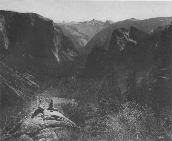
But you have ducked the question about the ladies sitting on the rock (the photo on page three) in that article in Yosemite Magaine. You will recall that we argued about whether that rock was just at the north edge of Old Inspiration Point, or else over on Artist Creek somewhere. You thought that they were too low to be sitting at the point, and I thought that they were too high or too far east to be at the creek...


Edited 1 time(s). Last edit at 01/03/2012 08:33AM by wherever.
avatar Re: Inspiration Ridge, Mt. Beatitude, Hill's Point, and Artist Creek (part 2)
January 03, 2012 10:00PM
My head hurts. Give me a bit more time to go thru the pictures before this fool rushes in again.

Honestly I don't know why the person writing the article can't just put in a simple map and make it clear.


Chick-on is looking at you!
avatar Re: Inspiration Ridge, Mt. Beatitude, Hill's Point, and Artist Creek (part 2)
January 04, 2012 07:39AM
OK, rather than post 20 pictures right here...

Take a look at this set:
https://picasaweb.google.com/yosemite.chick.on/WhereverWhereArtThou?authkey=Gv1sRgCO7cj83rxJzjAQ

The photos are geotagged so open that view and take a look. The thing to really look at is
Lower Cathedral Rock in comparison to Glacier Pt. and the gap between it and The Lowest Brother/El Cap.

In the photo in question... it's unfortunate it's not clearer... but it appears to me that on the right is the cliff of Stanford.
(crystal clear in photos from Old Inspiration)

So wasn't able to find the rock.. but it's probably very near photo #9. Perhaps lower?
It's doubtful the rock is no longer with us in it's glorified form... Sigh... need to go look again...


BTW: If it makes you happy.. wink it seems that not only am I a nutcase.. but also a "dull clod of a soul"
(I wonder what Mr. Sidney Andrews would say of the rock climbers/slackliners of today)


Chick-on is looking at you!


Edited 1 time(s). Last edit at 01/04/2012 07:50AM by chick-on.
Re: Inspiration Ridge, Mt. Beatitude, Hill's Point, and Artist Creek (part 2)
January 04, 2012 11:37AM
Chick-on....it appears to me that your photo#8 is very, very close to your photo#3. If you look at the striations and cuts in the rock they appear almost the same. The older photo was obviously taken from above where you took yours, but I'd say you might have a match there. The old photo looks like there might've been more surface on the top of the right side of the rock, but with different lighting it might be deceiving.


Edited 1 time(s). Last edit at 01/04/2012 11:41AM by ProgMtl.
avatar Re: Inspiration Ridge, Mt. Beatitude, Hill's Point, and Artist Creek (part 2)
January 04, 2012 03:27PM
Thank you for looking. Obviously I put that photo in for a reason.
I just couldn't convince myself it was the same.
I actually climbed up on that rock... at least I'm fairly certain I did.


Chick-on is looking at you!
avatar Re: Inspiration Ridge, Mt. Beatitude, Hill's Point, and Artist Creek (part 2)
January 04, 2012 11:40AM
Quote
chick-on
OK, rather than post 20 pictures right here...

Take a look at this set:
https://picasaweb.google.com/yosemite.chick.on/WhereverWhereArtThou?authkey=Gv1sRgCO7cj83rxJzjAQ


I see only 16 photos in this set. Are there four more?


Quote
chick-on
The photos are geotagged so open that view and take a look.


The geotagged view doesn't seem to be enabled for that album. (I usually have to manually enable it on my albums. It's disabled by default.)


Quote
chick-on

So wasn't able to find the rock.. but it's probably very near photo #9. Perhaps lower?
It's doubtful the rock is no longer with us in it's glorified form... Sigh... need to go look again...


Photo #9 looks to be very very close. I think though that the rock might be ever so slightly HIGHER, not lower, than your photo. Did you look behind you for that rock by any chance?

Also, are you in agreement with Hank Johnston's assessment that Mount Beatitude and Old Inspiration Point is one and the same (but different from the 'Original' Inspiration Point by the old Indian Trail and seen by James Hutchings during his first visit to Yosemite)?


avatar Re: Inspiration Ridge, Mt. Beatitude, Hill's Point, and Artist Creek (part 2)
January 04, 2012 03:25PM
Quote
plawrence
I see only 16 photos in this set. Are there four more?
What for?
(read the for as four)
(ok, I yoking... the 20 was just a random large number)

Quote
mr lawrence
The geotagged view doesn't seem to be enabled for that album. (I usually have to manually enable it on my albums. It's disabled by default.)
Thanks. Yeah. Ran into that problem before. Try getting geotags to work with free acount. What a pain in the rump.
They should show up now.

Quote
peter
Photo #9 looks to be very very close. I think though that the rock might be ever so slightly HIGHER, not lower, than your photo. Did you look behind you for that rock by any chance?

Also, are you in agreement with Hank Johnston's assessment that Mount Beatitude and Old Inspiration Point is one and the same (but different from the 'Original' Inspiration Point by the old Indian Trail and seen by James Hutchings during his first visit to Yosemite)?

This is the way I see it:
- Mt. Beautitude and Old Inspiration Pt. are one and the same
- "Original" Inspiration Pt. .. I called it "Wherever Pt." - that is where Hutchings first saw Yosemite Valley
I believe Wherever called this Mt. Beautitude. A Rose is rose.. Wherever Pt. - Mt. Beautitude.
smiling smiley


Chick-on is looking at you!
Re: Inspiration Ridge, Mt. Beatitude, Hill's Point, and Artist Creek (part 2)
January 04, 2012 04:10PM
Quote
plawrence

Also, are you in agreement with Hank Johnston's assessment that Mount Beatitude and Old Inspiration Point is one and the same (but different from the 'Original' Inspiration Point by the old Indian Trail and seen by James Hutchings during his first visit to Yosemite)?


At the risk of repeating all these arguments (see earlier on this thread:http://yosemitenews.info/forum/read.php?3,48350,49209#msg-49209), we hashed this out, and were convinced by scholarship:

1) That the original Mariposa party came up from Grouse Creek and that the original Mount Beatitude was in fact what we call New Inspiration Point. (see article http://www.yosemite.ca.us/library/yosemite/60-2.pdf )

2) That following generations were confused by the vague recollections of Bunnell 30 years later, and got to calling just about everything up there Mt Beatitude and/or Inspiration Point at various times. (See article http://www.yosemite.ca.us/library/yosemite/59-4.pdf and see this current thread from the beginning.)

Quote
chick-on

A couple of comments from the magazine:
I can't make sense of this:
"At a place 0 .3 miles southwest of
"Inspiration Point " (1), the Manns cleared a 150-yard
side trail north through the dense brush to a rocky peninsula
first called "Mount Beatitude," elevation 6,603 feet."

SW?? I'm confused

No, it's clear enough. He is referring to what we call "Old Inspiration Point". What he is calling "Inspiration Point" is the one right next to the old trail, what I called "Mt Beatitude" early in this thread, before I knew better, and what you called "wherever point" in this last post. What I called "2" and "1" respectively in the google earth view at the end of the first post in this thread.

Maybe we can just call them 1, 2, and 3 if we can't all agree.


Edited 1 time(s). Last edit at 01/04/2012 06:55PM by wherever.
avatar Re: Inspiration Ridge, Mt. Beatitude, Hill's Point, and Artist Creek (part 2)
January 04, 2012 05:07PM
Quote
wherever
Maybe we can just call them 1, 2, and 3 if we can't all agree.

As already pointed out by the 59-4 magazine (but can't help but pointing out again).
1, 2, and 3 at one pt. or another seem to have been called Inspiration Pt.
Couple that with the current Inspiration Pt. and Rainbow View ("New Inspiration Pt" at one time)
and you have that article.
Remember that the two ladies on the bold prom. pict. is approx at #3.

I sorta wish they would have been a little more inspired to come up with better names.
I actually like your names the best to be honest (ok, I like Wherever Pt.)
Another nit I have is... If it were up to me... I would have spent the cash and had a trail
only to Old Wawona Rd. and taken the money used to create the trail
from Old Wawona up to Inspiration Pt. to make the trail from there up to the rim
much more scenic. It's yet another in the huge examples of trails that just aren't
in the best location. It would have been pretty darn nice to have the trail run
right next to Hill's Pt. and also a spur to Old Inspiration should still exist.
The Old Wawona Rd. is a fun little trek which is missed by most and using it to get
to Inspiration Pt. is definitely worthwhile.

Keep Exploring (and please don't be toooooo mad at me)


Chick-on is looking at you!
Re: Inspiration Ridge, Mt. Beatitude, Hill's Point, and Artist Creek (part 2)
January 04, 2012 11:43AM
Quote
chick-on
OK, rather than post 20 pictures right here...

Take a look at this set:
https://picasaweb.google.com/yosemite.chick.on/WhereverWhereArtThou?authkey=Gv1sRgCO7cj83rxJzjAQ

The photos are geotagged so open that view and take a look. The thing to really look at is
Lower Cathedral Rock in comparison to Glacier Pt. and the gap between it and The Lowest Brother/El Cap.

In the photo in question... it's unfortunate it's not clearer... but it appears to me that on the right is the cliff of Stanford.
(crystal clear in photos from Old Inspiration)

So wasn't able to find the rock.. but it's probably very near photo #9. Perhaps lower?
It's doubtful the rock is no longer with us in it's glorified form... Sigh... need to go look again...


BTW: If it makes you happy.. wink it seems that not only am I a nutcase.. but also a "dull clod of a soul"
(I wonder what Mr. Sidney Andrews would say of the rock climbers/slackliners of today)

What are you talking about? You were there:


Look at the crack pattern on the face of the rock. Allowing for different shadows, it is certainly the spot.

As for the "glorified forms", they have gone off and become someone's great grandmothers.
avatar Re: Inspiration Ridge, Mt. Beatitude, Hill's Point, and Artist Creek (part 2)
January 04, 2012 03:40PM
Sigh. You know. I don't know what I'm talking about.

I actually stared at that darn rock when I was there for awhile. Took out the photo. Climbed up on it.
And couldn't convince myself. After getting up Old Inspiration again (my leg modelling career has long
passed me by ... btw), I was certain it was down by Hill's Pt.
(again, so much so that I climbed back up there the next day)
After getting home I saw that photo and said hmm... and still couldn't convice myself 100%.

Anyway, I will go back again sometime and look again. (I soooooo want to take the wife or Old Dude to Wherever Pt.)
(hopefully when Silver Strand is at it's peak) (what a great spot) (don't tell anyone though)

A couple of comments from the magazine:
I can't make sense of this:
"At a place 0 .3 miles southwest of
"Inspiration Point " (1), the Manns cleared a 150-yard
side trail north through the dense brush to a rocky peninsula
first called "Mount Beatitude," elevation 6,603 feet."

SW?? I'm confused

The other thing was the rock outcropping. Obviously that is not Hutching's "bold promontory of rock".

Your comment w/r to the grandmothers... I find particularly amusing. While atop Inspiration Ridge...
I was thinking that when I "grow up"/"become re-incarnated" I want to be granite... since I love it so much.

Thanks for all your time and knowledge and patience


Chick-on is looking at you!
avatar Re: Inspiration Ridge, Mt. Beatitude, Hill's Point, and Artist Creek (part 2)
January 04, 2012 03:44PM
Ah.. I got it. .3 miles from "Inspiration Pt." (1).

What he is saying is that "Inspiration Pt." (1) is Old Inspiration Pt.
The confusion came to me b/c of the (1) (which has the ladies on that darn promontory)
.3 miles SW from OLD Inspiration Point you'll run into the trail.


Chick-on is looking at you!
Re: Inspiration Ridge, Mt. Beatitude, Hill's Point, and Artist Creek (part 2)
January 15, 2012 03:56PM
Quote
wherever
Quote
chick-on
OK, rather than post 20 pictures right here...

Take a look at this set:
https://picasaweb.google.com/yosemite.chick.on/WhereverWhereArtThou?authkey=Gv1sRgCO7cj83rxJzjAQ

The photos are geotagged so open that view and take a look. The thing to really look at is
Lower Cathedral Rock in comparison to Glacier Pt. and the gap between it and The Lowest Brother/El Cap.

In the photo in question... it's unfortunate it's not clearer... but it appears to me that on the right is the cliff of Stanford.
(crystal clear in photos from Old Inspiration)

So wasn't able to find the rock.. but it's probably very near photo #9. Perhaps lower?
It's doubtful the rock is no longer with us in it's glorified form... Sigh... need to go look again...


BTW: If it makes you happy.. wink it seems that not only am I a nutcase.. but also a "dull clod of a soul"
(I wonder what Mr. Sidney Andrews would say of the rock climbers/slackliners of today)

What are you talking about? You were there:


Look at the crack pattern on the face of the rock. Allowing for different shadows, it is certainly the spot.

As for the "glorified forms", they have gone off and become someone's great grandmothers.


So, we were in Yosemite on Wednesday, and my buddy wanted to hike a section of the Pohono Trail that he had never done. Sentinel Dome to Stanford Point. It's mid-January, but there is very little snow and we thought that it would be OK with just hiking boots. In fact, that was true, except for the stretch from the bridge at Bridalveil Creek to Dewey Point. That section is always in the shade at this time of year, and had a few inches of dense, shiny, refrozen snow. Slippery as hell. Fortunately, there was a set of old footprints that had melted down to slight indentations, but which had collected a thin coat of pine needles in those hollows. It was like those dance floor painted footprints. You could step carefully from one pine needle print to another, but if you stepped anywhere else you went for a ride....

We hit every named point along the way. After Stanford Point, we had intended to perhaps go up Meadow Brook, but its meadow was also ice covered, and there were no footprints. So we stayed on the trail, which was pretty much clear from that point on. This also gave us a chance to stop at some of the places mentioned in this thread, and clarify the description of how to get to "Mt Beatitude" as we had been calling it. (Not the original Mt Beatitude, which we now believe is at New Inspiration Point).

Here's how to find it: Going west from Stanford Point, the trail crosses Meadow Brook, and then climbs a short hill. Just west of the top of that is a metal sign facing east, which says "Inspiration Point 1.9" Forty feet west of that is a break in the bushes on the right with a use trail over to a visible rock that you can get up on. That's not it...the views there are poor and you can't see Silver Strand Falls. But a faint left fork of the use trail goes around the rock on its left side, leaving you with a steep easy bushwhack down to the real lookout point. You can't see it from above, but it's only 80 vertical feet below the trail, so it soon comes in view as you descend. It is a large and level vista point.


Silver Strand Falls had been a frozen ribbon earlier, but it suffered an accident soon before we got there:


We also stopped at Hill's Point on the way down. Unfortunately, I hadn't though to bring the coordinates that can be extracted from Chick-on's posted photo of the Ladies' Rock, so we missed it. It would be here at the 6200 foot line, about a hundred feet below the Pohono Trail:


In this picture, X is Old Inspiration Point, L is the Ladies' Rock, and H is Hill's Point.

It's been a January to remember. Now, pray for snow.
avatar Re: Inspiration Ridge, Mt. Beatitude, Hill's Point, and Artist Creek (part 2)
January 15, 2012 10:44PM
Berry kewl. Was going to head up there again this last Saturday...
woulda been kinda funny to run into you.... however.. with
GP road open ... decided to hike the Old 4 Mile Trail down to
Union Pt. and back up (yum yum)....

Here's Silver Strand from Tunnel View though... some nice lighting:


Chick-on is looking at you!
avatar Re: Inspiration Ridge, Mt. Beatitude, Hill's Point, and Artist Creek (part 2)
May 07, 2012 03:09PM
Went back up in that area... and I'm convinced beyond much doubt that that it is indeed
the "Ladies Rock". Also visited Hill's and Mt. Beautitude/Wherever Pt. It's spectacular now.
Then again, what isn't in Yosemite?


and a neat little cicular thing-a-ding :


Tanks
Have fun Wherever you go


Chick-on is looking at you!
avatar Re: Inspiration Ridge, Mt. Beatitude, Hill's Point, and Artist Creek (part 2)
May 07, 2012 04:44PM
Quote
chick-on

Also visited Hill's and Mt. Beautitude/Wherever Pt. It's spectacular now.
Then again, what isn't in Yosemite?


I would guess this...


wink

(And thanks for the update on Ladies Rock and Hill's Point. Love that self-portrait of you inside that arch!)

.
avatar Re: Inspiration Ridge, Mt. Beatitude, Hill's Point, and Artist Creek (part 2)
January 03, 2012 11:54AM
Have a great year too!

BTW, did you eat that Boyardee beef ravioli cold, or did you heated it up?

Also, by any chance, did you come across the hallowed sugar pine mentioned by Hutchins?


avatar Re: Inspiration Ridge, Mt. Beatitude, Hill's Point, and Artist Creek (part 2)
January 03, 2012 10:03PM
Quote
plawrence
BTW, did you eat that Boyardee beef ravioli cold, or did you heated it up?
Pop it open and eat away. Nom nom nom
(I do the same with Hormel Chili)

Quote
peter
Also, by any chance, did you come across the hallowed sugar pine mentioned by Hutchins?
In the Yosemite Magazine 59-4. The cover photo. There is the tree. It has since fallen (geez, I wonder why).
That photo is without a doubt taken from current day "Old Inspiration Pt.".


Chick-on is looking at you!
avatar Re: Inspiration Ridge, Mt. Beatitude, Hill's Point, and Artist Creek (part 2)
January 04, 2012 12:50AM
Thanks for pointing the tree out.

The cover photo doesn't show the base of the tree, so I wouldn't have known that was the hallowed out sugar pine that Hutchins referred too.

Mystery solved. Thanks!
Sorry, only registered users may post in this forum.

Click here to login