Welcome! Log In Create A New Profile Recent Posts
Tenaya Lake, Yosemite National Park

The Moon is Waxing Gibbous (59% of Full)


Advanced

Re: Aerial pics from plane of Northern Yosemite

All posts are those of the individual authors and the owner of this site does not endorse them. Content should be considered opinion and not fact until verified independently.

Aerial pics from plane of Northern Yosemite
September 22, 2012 10:17AM
2012 Yosemite trip; Part 1, Rockslides to Cascade Creek

Yosemite 2012 trip. Day 2: Cascade Creek to Yosemite Falls

2012 Yosemite Trip, Part 3 (days 3-5): YOsemite FAlls to Olmstead Point and May Lake

2012 Yosemite Trip, Part 4 (days 6-8); Tuolumne Meadows, Glen Aulin, Cold Canyon, Miller Lake, Matterhorn Canyon, Burro Pass

2012 Yosemite Trip, Part 5 (days 9 and 10): Slide Canyon; Mule Pass; Crown, Robinson, Peeler Lakes; Kerrick Canyon, Peeler Lake, Rodgers Lake

2012 Yosemite Trip, Part 6 (days 11-13): Rodgers Lake, Rodgers Meadow, Pate Valley Grand Canyon of the Tuolumne, Waterwheel Falls, Le Conte Falls, Tuolumne Meadows

Aerial pics from plane of Northern Yosemite

When I flew into Sacramento on the way to Yosemite from Las Vegas in 2010, I was sitting on the east facing side of the plane and the west-most thing I could see was Lake Tahoe. Heading back, the flight was going to Chicago, and I think I forgot to look or did not have a window seat. This time, heading again from Vegas to Sacramento, I forgot and again sat on the east-facing side of the plane. Again-- Tahoe. But, unlike in 2010, on the way back I connected through Vegas and decided I'd try the west-facing side and see if I could see anything. I almost forgot to look out the window in time. When I did, I was totally disoriented, but I thought the area had potential. I had to start superimposing the maps in my head onto the visual feast laid out in front of me, and at one point I had that "Aha" moment and knew I where I was. It was very cool, because the area of Yosemite that was closest was the northern region -- exactly where we had been tromping around for 8 days, and in the distance the places we had been in the 5 days prior. While I can identify some things in the pics (including the airplane wing), many I cannot yet. I need to get a map out and look at them together. In any case, these are some of the images. They can be found here in full resolution along with a couple others:


Picasa gallery of these and a couple more at higher resolution


Edited 3 time(s). Last edit at 02/18/2023 05:21PM by Frank.
avatar Re: Aerial pics from plane of Northern Yosemite
September 22, 2012 01:21PM
Really nice. I love the ariel shots. Especially when you can recognize lakes and other features
Re: Aerial pics from plane of Northern Yosemite
September 22, 2012 01:32PM
These are great! In almost all of them you can identify Half Dome, Tuolumne Meadows, and/or a major lake (Twin, Benson, Tenaya, Grant) to get oriented. The major canyon cutting horizontally across the first few is the Grand Canyon of the Tuolumne/Hetch Hetchy. The smoke is probably from the Cascade fire.

I especially like the third from the bottom--excellent view down Tenaya Canyon. Most of the high points of Yosemite Valley (even El Cap!) and the Cathedral Range are visible. Tenaya Lake is right in the middle. Very nice!
Re: Aerial pics from plane of Northern Yosemite
September 22, 2012 04:22PM
Tuolumne Meadows is very striking from this view in the air compared to all that surrounds it. The various canyons are quite dramatic as well. I believe I can make out Rogers Lake and what I think is Volunteer Peak (where we camped one night), but I have had trouble figuring out where Miller Lake is. It should be in several of these pics but I haven't yet nailed it down. I'm also not quite sure where Seavey Pass and our path through that area after leaving Kerrick Canyon on way to Benson lake. For some reason the hike over Seavey was a bit disorienting and went on for longer than it seemed like it should have.
avatar Re: Aerial pics from plane of Northern Yosemite
September 23, 2012 09:00AM
Frank,

You are correct. In the 3rd frame I can clearly see Volunteer Peak, Rodgers Lake, Smedburg Lake, and Sister Lake. The one thing I'm having trouble reconciling is the huge squiggle in Matterhorn Canyon in the foreground north of the Benson Pass area. It just does not seem that sharp a bend on the topo maps. Perhaps a camera affect?
avatar Re: Aerial pics from plane of Northern Yosemite
September 24, 2012 07:07AM
All the photos with Benson in them have Miller too. But it's really really hard to see.
The best one is the one with Benson and Cold Canyon in it. Find Cold Canyon
(the big meadow north (below) Tuolumne Meadows) and then head diagonally
down and to the right (NW). Remembering that Miller has a large meadow
on it's north side may help quite a bit in locating it.
How did you possibly sleep ATOP Volunteer?


Chick-on is looking at you!
avatar Re: Aerial pics from plane of Northern Yosemite
September 24, 2012 07:46AM
Quote
chick-on
All the photos with Benson in them have Miller too. But it's really really hard to see.
The best one is the one with Benson and Cold Canyon in it. Find Cold Canyon
(the big meadow north (below) Tuolumne Meadows) and then head diagonally
down and to the right (NW). Remembering that Miller has a large meadow
on it's north side may help quite a bit in locating it.
How did you possibly sleep ATOP Volunteer?

He found a soft bed of chicken feathers up there.
Re: Aerial pics from plane of Northern Yosemite
September 24, 2012 08:43PM
<laughing> We did not camp atop V'olunteer Peak. I was sloppy in the placement of my parenthetical phrase. We camped at Rogers Lake. Sorry for the confusion.

I still haven't found Miller yet. I feel like I'm looking right at it (following your guidance) , but can't quite spot it yet. I'll get my maps out and see if that helps.
avatar Re: Aerial pics from plane of Northern Yosemite
September 24, 2012 09:31PM
Of course it begs the question ... did you go up Volunteer.
(and btw... it's Rodgers) smiling smiley

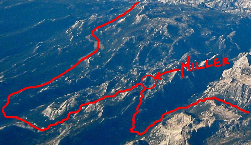
I'll help you out with Miller. Cropped from the one with Benson and the curved wing portion:

I drew in the approx route of the trail...


Chick-on is looking at you!
Re: Aerial pics from plane of Northern Yosemite
September 24, 2012 09:55PM
Thanks! Now I can see it clearly.

We did not make it up Volunteer. That day was a long one and a tiring one. We left that morning from the northern end of Kerrick Canyon and slept at Rodgers Lake, with a stop and a swim at Benson. We started the day kind of late, and after a couple hours at Benson, did not make it to Rodgers until well after dark. So, it was an adventure. The next day we needed to get to Pate Valley and up-canyon a bit to find a camping spot, so we decided against the Volunteer fun. I definitely want to go back there and do it. Rodgers Lake was beautiful. We talked to a variety of people we met at various times about Table Lake. Without exception they looked at us like we were insane. I should say that it wasn't table lake itself, but rather they did not have good things to say about the trail there and back or the general area (Pleasant Valley?) So, we vetoed that as well, particularly since at this point we were a bit tired and somewhat unsure of what lay ahead in the Grand Canyon of the Tuolumne.

I'll write a trip report soon. We loved MillerLake, Matterhorn Canyon, Mule and Burro Pass, the area outside of the park on the north side, Peeler and Kerrick Canyon (which was simply beautiful). That whole stretch was stunning.
avatar Re: Aerial pics from plane of Northern Yosemite
September 25, 2012 07:54AM
Quote
Frank
Thanks! Now I can see it clearly.

We did not make it up Volunteer. That day was a long one and a tiring one. We left that morning from the northern end of Kerrick Canyon and slept at Rodgers Lake, with a stop and a swim at Benson. We started the day kind of late, and after a couple hours at Benson, did not make it to Rodgers until well after dark. So, it was an adventure. The next day we needed to get to Pate Valley and up-canyon a bit to find a camping spot, so we decided against the Volunteer fun. I definitely want to go back there and do it. Rodgers Lake was beautiful. We talked to a variety of people we met at various times about Table Lake. Without exception they looked at us like we were insane. I should say that it wasn't table lake itself, but rather they did not have good things to say about the trail there and back or the general area (Pleasant Valley?) So, we vetoed that as well, particularly since at this point we were a bit tired and somewhat unsure of what lay ahead in the Grand Canyon of the Tuolumne.

I'll write a trip report soon. We loved MillerLake, Matterhorn Canyon, Mule and Burro Pass, the area outside of the park on the north side, Peeler and Kerrick Canyon (which was simply beautiful). That whole stretch was stunning.

Frank,

I'm sitting here laughing my butt off about your comments regarding Table Lake. As a result of bill-e-g touting the fabled Table Lake (for years) we included it in our hiking plan last year. The 1st ranger we met up with in Cold Canyon was surprised we were including it as an overnight side trip, expressing her doubts about its appeal in return for the effort to get there. I've made jokes about earning a Table Lake t-shirt if I made the effort to go there. Anyway, like you, we cancelled that side trip and knocked an entire day off our trip doing so. We had also planned to summit Volunteer Peak but arrived in late afternoon after a long day and were too exhausted to go boulder hopping. Setting up camp at Rodgers Lake looked a whole lot more appealing at that point.

How did you make out finding a place to camp in the Grand Canyon above Pate Valley and how far did you go the next day to camp?
avatar Re: Aerial pics from plane of Northern Yosemite
September 25, 2012 08:14AM
I have no idea wutt doz peeps talkin bout.
I've been to Loch Tablae. It kicks booty!

(actually I really have no idea what they talking about... maybe they are
complaining about the trail up and over Rancheria Mountain)
(I see no reason to complain about up from Pate since you have to
go up that way to get to Rodgers)
I will give you that Pleasant Valley doesn't have much views... although
there is a beautiful cascade coming into it...
It's all about timing. Go there in early season. Maybe you'll like it more
... or maybe you'll go there too late and get smacked by bugs...

Anywho, Rodgers Lake and Loch Tablae are two different animals.


Chick-on is looking at you!
avatar Re: Aerial pics from plane of Northern Yosemite
September 25, 2012 11:28AM
Quote
chick-on
I have no idea wutt doz peeps talkin bout.
I've been to Loch Tablae. It kicks booty!

(actually I really have no idea what they talking about... maybe they are
complaining about the trail up and over Rancheria Mountain)
(I see no reason to complain about up from Pate since you have to
go up that way to get to Rodgers)
I will give you that Pleasant Valley doesn't have much views... although
there is a beautiful cascade coming into it...
It's all about timing. Go there in early season. Maybe you'll like it more
... or maybe you'll go there too late and get smacked by bugs...

Anywho, Rodgers Lake and Loch Tablae are two different animals.

You feelin daat tug on der leg?grinning smiley
Re: Aerial pics from plane of Northern Yosemite
September 26, 2012 09:25PM
WEll, I was definitely intrigued by Loch Tablae, but I just couldn't find anyone who had even something small to say about that general area. I heard that the trails were terrible (loose slippery gravel type stuff), that it was snake infested, ugly, UGLY, etc. Had I been a bit "fresher" I would almost have wanted to go just to find out for myself. But, at that point, my "up and down" was just about worn out. So, for now it will remain in the realm of fable and lore.

We did find a good campsite about a mile up from Pate Valley as you had said. There were some folks camped pretty much in the middle of the trail a bit lower, but the spot we found was on a large blackish rock shelf and made for a great campsite. We spent some time that night watching the full moon rise over whatever the highest point to the east of us was while simultaneously watching it light up the canyon in the other direction well before we ever could see the moon. Just before the moon crested the top of that "mountain", we could see the light racing towards us on the ground. It was fun!

The next day we made it to Waterwheel falls and camped just a tad upstream of that. That was a rough day for me for some reason. I think the previous 11 days had caught up with me, and particularly the previous two days. It was kinda weird. I could move find on flat ground, pretty good going downhill, but uphill was a struggle. The muscles involved in going up were striking. We managed to get the places we needed to get, but the hike over muir gorge sucked for me that day. And on the next day, the hike up out of Glen Aulin sucked a bit as well. I'm going to need to get myself in better condition before next time. Still, all in all, we managed quite well. My nephews of course were fine. The couldn't understand why I had started moving slow but was not hurting.

At Waterwheel falls we were able to walk out pretty much right next to the waterwheel. I'm guessing that during heavy water flow, all of that rock is covered with water. I'd love to see that canyon with a lot of water in it.

We ran into about 3 groups who had been through the GCT or pate Valley and all said they had seen more than one rattlesnake. We did not see any, with the possible exception of one small snake that dashed across the trail in front of me so fast I could not describe it. One group had warned us of a hornets nest on the trail. We had sorta forgotten about it when we looked down and say a nice little note that identified where the hornets nest was. Beside the hornet's nest was an "air force one" baseball cap. One nephew decided to take to the river which did not appeal to me much as it was large boulders that did not seem close enough for me to hop from one to the other. So, I opted for the trail, moving quickly and trying to avoid where I thought the nest was. Another nephew followed. Me made it through fine.

I have decided that Yosemite is an apparent mecca for Boy Scout troops. We ran into several, and more often than not, they unwittingly provided entertainment.

It was a great trip.
avatar Re: Aerial pics from plane of Northern Yosemite
September 27, 2012 07:43AM
Frank,

I wonder if you saw the same small snake I did? eye rolling smiley It too dashed across the trail so fast I could not identify it, about half way down the Piute Creek switchbacks before Pate Valley. It definitely was not a rattler.
We went all the way from Return Creek to the stables road near Lembert Dome the last day, about a 2,150' ascent to the footbridge above Glen Aulin HSC. That last climb from the HSC is only about 450' but after two days of steady climbing you're ready to say, "enough". Also, that last couple of miles to TM just drags on and on.

The entire route you did is a workout if you have never done anything quite like it before. What's next?
Re: Aerial pics from plane of Northern Yosemite
September 27, 2012 08:32PM
We did a pretty extensive backpacking trip in Yosemite 2 summers ago over the course of ~ 11 days, but I think the one we did this summer was more difficult ( and a couple days longer). If we lived closer it would be easier to get to Yosemite more frequently, but with me in Cleveland and my nephews in Nashville, it requires a lot of planning, time, etc. I always feel the draw of Yosemite and will get back there as soon as I can. At present, I have my eyes set on a trip to Glacier NP. The best window of time to go there with the most options of backpacking trails (that are not impassable with snow) is August and September (at least that's my understanding). That has made it impossible to go until my nephews are out of HS, which will be true this coming year. So, with any luck, we may make it there in 2013!!
avatar Re: Aerial pics from plane of Northern Yosemite
September 25, 2012 05:38PM
Frank,
The one with the curved wing with "SOUTH" clearly visible... also has Miller in it.
(and Benson... and ...) If you can't find it I can circle it 4u.
Love love love these... Almost every darn time I fly over The Yosemite in one of those
big tin cans... I go and pick the wrong darn side o the plane!
Thanks for sharing!


Chick-on is looking at you!
Re: Aerial pics from plane of Northern Yosemite
September 26, 2012 10:10PM
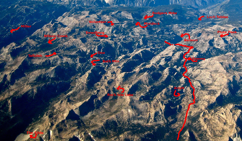
I believe I found it. This is the pic with Benson on the far right and just a bit of airplane wing on upper left. It's a different angle, but I'm pretty sure I've identified it. I think it's fun to look at these as I see something new each time. I was just noticing the meadows at the north end of Cold Canyon (we camped in one of these). I have tried to locate the "slide' but am not sure it is in any of these pics. I thought it might be, but I have not found it. At first I thought I found it in the first pic, but I have since decided that pic has Twin Lakes and Tilden Lake in it along with Jack Main Canyon. Now, I think the second pic may have the slide in it, visible in the extreme lower left corner, and that Rock Island Lake is visible a bit above and to the right of that. And the meadows of Kerrick Canyon would then be out of frame at the bottom?

Seavey Pass, the path over it between Kerrick Canyon and Benson Lake remains a bit of a mystery. This was one of the few places that even when there I really could not find my bearings. Seavey seemed to go on forever and I could never really tell where I was.
avatar Re: Aerial pics from plane of Northern Yosemite
September 27, 2012 07:10AM
Yes, the second one has THE Slide in it. Did you go check it out?
I dunno this ruins it for you... I hope not... but I annoted that one a bit
and drew in the trail to Benson from the north.


Have fun


Chick-on is looking at you!
Re: Aerial pics from plane of Northern Yosemite
September 27, 2012 09:02PM
Thanks for the annotation! That helps.

Well, we did not hike down to the slide in slide canyon. We camped at a place that may be the spot you recommended between Mule and Burro pass. I'm not sure if it was technically in Slide Canyon or not. We had crossed the first pass and headed down, largely through very wooded areas. There were some areas of very very extensive recent tree blowdowns that proved challenging. For some reason I had it in my mind that the granite bench you had mentioned was the low spot between the passes, but instead we found no such area at the lowest point, and had to head back up towards the next pass (as we needed to also find water). We ended up at a large granite bench that was adjacent to a stream, which had room for multiple campsites, and there were fire rings there, even though I think this was definitely above 9600 feet. It had a great view down slide canyon which we could best appreciate the next morning in better light. It is an amazing site to look at, and I'm sure if you were to walk down to it that the scale can really be appreciated. It truly appears as thought it just happened (the bright white rock), and yet it seems it happened around 1740.

There's some interesting info in this article: Catastrophic rockfalls and rockslides in the Sierra Nevada, USA; Reviews in Engineering Geology, Volume XV, 2002, Gerald F. Wieczorek

Quote

" The large Slide Mountain rockslide of 1.9 × 10⁶ m3 rock
occurred in a remote part of northern Yosemite National Park
within the drainage of Piute Creek, a glaciated valley near the
crest of the Sierra Nevada (Bronson and Watters, 1987) (Fig. 1,
site 1). The locations of this and other rockfalls and rockslides
in the Sierra Nevada discussed in this chapter are shown in Figure
1. The Slide Mountain rockslide was first described by
McClure (1895, p. 175–176) during 1894 while exploring the
canyons of the Tuolumne River in the northern part of Yosemite
National Park.
After traveling three and one-half miles down the canyon,
I came to the most wonderful natural object that I ever beheld.
A vast granite cliff, two thousand feet in height, had literally
tumbled from the bluff on the right-hand side of the stream with
such force that it had not only made a mighty dam across the
canyon, but many large stones had rolled up on the opposite
side. As it fell it had evidently broken into blocks, which were
now seen of almost every size, piled one upon another in the
wildest confusion. The smaller particles had settled between the
crevices, leaving great holes among the larger blocks, some
which weighed many tons. To look at it, one might think that it
had occurred but yesterday; but it was, in all probability, ages
ago, as the ground just above the slide is two hundred feet or
higher than just below, showing that earth has accumulated on
the upper side for many years.
The scarp of the rockslide near the crest of Slide Mountain is
3230 m in elevation; glacial polish and striations indicate that
Tioga (latest Pleistocene) glaciation filled Slide Canyon to the top
of the scarp (Bronson and Watters, 1987). The slide descended to
the floor of the valley, a drop of 430 m, and continued up the
opposite valley slope another 37 m, indicating that the mass was
moving extremely rapidly at 63 m/s when it crossed the floor of
the valley (Huber et al., 2002) (Fig. 3). The deposit, which contains
many blocks exceeding 6 m (Huber et al., 2002), blocked
Piute Creek with a small landslide dam 12 m high (Fig. 4). The
area upstream from the dam that probably became a small lake or
pond has since formed into a marshy meadow (Huber et al.,
2002). The unweathered appearance of the rocky deposit (Fig. 5),
almost devoid of vegetation, makes it appear fresh, suggesting
that the slide occurred relatively recently; however, dendrochronology
of two samples of wood recovered from logs
pinned beneath boulders within the deposit has pinpointed the
event as occurring between A.D. 1739 and 1740 (Huber et al.,
2002). However, because the date of this event cannot be associated
with a known seismic or climatic event, its specific cause or
trigger remains unknown (Huber et al., 2002). "
avatar Re: Aerial pics from plane of Northern Yosemite
September 28, 2012 07:35AM
Yeah, I know what you talking about w/r to the blow-downs in Slide Canyon.
Walked by those mid July on our trek. Took a number of pix. We only stuck
to the trail for about a mile entirely after Burro after coming up Matt. Can though.
Took a lot of pix of The Slide this year... but I still like the one's took when we
hike right thru it a number of years ago... Here's two:


and in it:


Have fun


Chick-on is looking at you!
Re: Aerial pics from plane of Northern Yosemite
September 28, 2012 01:07PM
These are GREAT pictures of the slide. In the one in which someone is on the rocks, is this in the bottom of the canyon or did you wander "up" the slide some. It seems like you are at an elevation. If in the bottom of the canyon on the rocks, how high up is the pile of rocks above the surrounding canyon floor? When I was there looking at it from a distance, I was wondering whether it was reasonable for a person to traverse across the "pile" of rocks or whether the size of the rocks would make it really difficult.

Thanks for the pictures!
avatar Re: Aerial pics from plane of Northern Yosemite
September 28, 2012 04:54PM
By in it... I mean we hiked across it on the canyon floor. Boulder hoping along.
The boulders are car and bus size. And even though it is only 1/2 mile across on the floor
it will probably take an hour to do it. I thought the photo of my wifie in among the boulders
would give the scale of things. This year we simply hiked around it on the south side
which includes zero boulder hoping... just walking up in the woods.
Here's three more from the traverse thru it to give you some more feeling of the size of things:
Getting closer to it:


Wifie in it (well... I'm in it too... just ahead of her at the moment) (this is maybe 1/2 way thru):


The other side is near:


Enjoy


Chick-on is looking at you!
avatar Re: Aerial pics from plane of Northern Yosemite
September 29, 2012 05:34AM
Wow, that is one surreal looking slide! Nice pics too.
Re: Aerial pics from plane of Northern Yosemite
September 29, 2012 07:00AM
CRAzy. I want to do that someday. Thanks for the images.
avatar Re: Aerial pics from plane of Northern Yosemite
September 24, 2012 02:14PM
Quote
basilbop

I especially like the third from the bottom--excellent view down Tenaya Canyon. Most of the high points of Yosemite Valley (even El Cap!) and the Cathedral Range are visible. Tenaya Lake is right in the middle. Very nice!

And you can even spot Turlock in the distance! wink

.
Re: Aerial pics from plane of Northern Yosemite
September 24, 2012 03:45PM
You can barely make out a silo. winking smiley
Re: Aerial pics from plane of Northern Yosemite
September 22, 2012 03:08PM
Really awesome photos, thanks for sharing them.

My favorite is the third from bottom. So many great things visible: Half Dome, Yosemite Valley, Tenaya Canyon + Lake, Cathedral Peak, TM, Young Lakes, and I think the summit of Conness in the lower right.
Re: Aerial pics from plane of Northern Yosemite
September 22, 2012 05:11PM
Immediately recognized Excelsior Mountain and Saddlebag Lake. I was greatly impressed at how well current camera technology can take such detailed images despite usual airliner vibration that in the past would only yield blurry pics. Last year took this pic and then anotated the image:

http://images.summitpost.org/original/746683.jpg

http://www.summitpost.org/kings-kern-divide/746683/c-181678


http://www.davidsenesac.com
Re: Aerial pics from plane of Northern Yosemite
September 22, 2012 07:33PM
Great pictures. Thanks for sharing. The only time I flew over Yosemite it was cloudy and you could not see anything.
avatar Re: Aerial pics from plane of Northern Yosemite
September 24, 2012 10:55AM
Great pics. More snow than I was expecting, and the Cascade fire has been burning for awhile. What date were these taken?
Re: Aerial pics from plane of Northern Yosemite
September 24, 2012 08:46PM
I was lucky that it was clear, that the flight path took me over the park, and that I looked out at the right time and realized where I was. I'm not skilled at photo-editing, so I used the basic tools in iPhoto to increase the contrast and remove some of the haze that normally accompanies photos from a plane.

The pics were taken on August 2nd of this year.
avatar Re: Aerial pics from plane of Northern Yosemite
September 24, 2012 08:52PM
I figured the photos looked more like early August, instead of September.
avatar Re: Aerial pics from plane of Northern Yosemite
September 24, 2012 02:15PM
Really nice photos! Thanks for sharing them.
avatar Re: Aerial pics from plane of Northern Yosemite
September 24, 2012 06:41PM
Wow, fun stuff. You must have been quite excited while taking those pics smiling smiley

Steve
Re: Aerial pics from plane of Northern Yosemite
September 24, 2012 08:49PM
You're right. When I realized what I was looking at it was thrilling. In fact I was torn between wanting to just look, and wanting to try to take pics so I could look more later. It was difficult to quit looking, and in fact I thought I was going to break my neck trying to look backwards until out of the edge of the window until it faded into the distance. There was a lot of other things to look at as we moved away from Yosemite on a flight path to Las Vegas, but I did not know what I was looking at. Fun stuff nonetheless.
Sorry, only registered users may post in this forum.

Click here to login