Recently we launched a website with an interactive map of Yosemite National Park where you can plan your hike and get detailed route analysis. You can find it here:
http://www.traillon.com/map/yosemite-national-park
It allows for checking approximate hiking time, distance, elevation change of the whole route and also between adjacent waypoints. You can also view elevation profile charts and share a link of the route with your friends.
I hope that you will like it, would also appreciate your feedback, cause it could help us better understand of what we can improve.

The Moon is Waxing Gibbous (95% of Full)
Re: Yosemite Hiking Map
All posts are those of the individual authors and the owner
of this site does not endorse them. Content should be considered opinion
and not fact until verified independently.
|
Yosemite Hiking Map February 19, 2017 08:30AM | Registered: 8 years ago Posts: 5 |
February 19, 2017 09:42AM | Moderator Registered: 15 years ago Posts: 7,421 |
It's pretty kewl. Nits and such:
- some trails are not correct or non-existent
(one example is the trail North or Tenaya Lake... we have seen people
walk by this junction because you need to know exactly where it is...
it's not really maintained, etc. anymore)
- some trails are missing
(Alder Creek, Kibbie for example)
- you should have the parking area at Happy Isles
- you should not have the parking area at Bridalveil
- you need to have the trailheads which originate outside the park
Quartz Mtn
Isberg
Kibbie
Eleanor
Sonora Pass
Leavitt Meadows
Buckeye
Twin Lakes Bridgeport
etc...
Otherwise planning is very restrictive... imo
Not sure I would put times on anything... peoples rate of travel greatly differs..
I wouldn't set them up to fail or compare... just my opinion
Can you do SEKI?
gaiagps.com also has route planning .. I haven't done enough there to compare...
Anywho... thanks for your work

Edited 1 time(s). Last edit at 02/22/2017 10:15AM by chick-on.
- some trails are not correct or non-existent
(one example is the trail North or Tenaya Lake... we have seen people
walk by this junction because you need to know exactly where it is...
it's not really maintained, etc. anymore)
- some trails are missing
(Alder Creek, Kibbie for example)
- you should have the parking area at Happy Isles
- you should not have the parking area at Bridalveil
- you need to have the trailheads which originate outside the park
Quartz Mtn
Isberg
Kibbie
Eleanor
Sonora Pass
Leavitt Meadows
Buckeye
Twin Lakes Bridgeport
etc...
Otherwise planning is very restrictive... imo
Not sure I would put times on anything... peoples rate of travel greatly differs..
I wouldn't set them up to fail or compare... just my opinion
Can you do SEKI?
gaiagps.com also has route planning .. I haven't done enough there to compare...
Anywho... thanks for your work
Edited 1 time(s). Last edit at 02/22/2017 10:15AM by chick-on.
|
Re: Yosemite Hiking Map February 19, 2017 05:37PM | Registered: 13 years ago Posts: 324 |
Cooooooooooooooooooool!
A couple observations:
1) It seems a bit odd that a hike can't start at Curry or that Majestic place.
2) You can't include EVERY destination in the park, but it would be
interesting to have off-trail spots like OMG Point, Sierra Pt., Diving Board
, etc. accessible. Somehow.
3) As Mr. Pink mentioned, the time thing doesn't seem to be needed.
Overall, this is a cool thing. Thanks.
|
Re: Yosemite Hiking Map February 19, 2017 06:24PM | Registered: 13 years ago Posts: 220 |
Quote
AnotherDave
Cooooooooooooooooooool!
A couple observations:
2) You can't include EVERY destination in the park, but it would be
interesting to have off-trail spots like OMG Point, Sierra Pt., Diving Board
, etc. accessible. Somehow.
NOOOOO! (please no?)
Edited 1 time(s). Last edit at 02/19/2017 06:25PM by troutwild.
February 19, 2017 10:34PM | Registered: 16 years ago Posts: 670 |
Quote
AnotherDave
. . . snip . . .
2) You can't include EVERY destination in the park, but it would be
interesting to have off-trail spots like OMG Point, Sierra Pt., Diving Board
, etc. accessible. Somehow.
. . . snip . . .
be careful with this
) not all of us want all of our 'private' spots to be known
) liability to you when someone gets hurt/killed while trying to follow your map, a LOT of the off-trail spots would be challenging for many people
|
Re: Yosemite Hiking Map March 31, 2017 04:27PM | Registered: 14 years ago Posts: 38 |
|
Re: Yosemite Hiking Map March 31, 2017 08:09PM | Registered: 10 years ago Posts: 74 |
Along the trail to the top of Yosemite Falls. You go past the Columbia Rock point, turn the corner and wow, there are the falls. See for instance http://www.yosemitehikes.com/yosemite-valley/lower-yosemite-falls/gallery-gosh.htm .
|
Re: Yosemite Hiking Map March 31, 2017 10:13PM | Registered: 14 years ago Posts: 38 |
March 31, 2017 11:08PM | Registered: 16 years ago Posts: 670 |
Just before you walk around the corner and get your first view of Upper Yosemite Falls look to the right/downslope for the patch of dirt. In fact, walk straight instead of turning the corner.
Once you know it's there you wonder how you ever missed it.
One of the best kept secrets in the valley
Once you know it's there you wonder how you ever missed it.
One of the best kept secrets in the valley
February 20, 2017 07:34AM | Moderator Registered: 15 years ago Posts: 7,421 |
Other comments after thinking about it more and playing with it a bit.
** You really need to be able to click on places within the section.
If you cannot then you have to guess what each day would look like exactly.
Ideally be able to have multiple sections in a trek. i.e. this is really required
if you are hedging it to backpackers. In other words... I'd like to know
where point xyz is on the line so that on day 1 I know more or less how far
it is... and etc.
As for the data itself. I did a trek we did last Sept and this is what I saw:
Yours : 47.5 15,780
Topo! : 46.25 12,000
Garmin mapsource: 46.75
I don't know which is right... we ended up doing 75 miles and 12,210 elevation
on that trip ... with a day of dayhiking... and off trail here and there...
(this is from the iPhone) gaiagps
Anyway... ok, other nit:
*** map really needs to have more detail... it is really lacking in lakes..
It doesn't even have all the named lakes on it
Take this as constructive criticism please. Overall it's great.
But I'll repeat you really need to have the outlying trailheads in.
I can go on and on as you improve if you like... but if no response or whatnot...
Then I'll stop here.
Have fun with it!
I LOVE maps
February 20, 2017 07:41AM | Moderator Registered: 15 years ago Posts: 7,421 |
I guess I didn't really make my point about the distances and all.
Maybe I didn't have one.
Ok, so... here's the deal... I dunno how many times have heard
this guy's map is sooo much better... it's great... what you are
using is not as good. blah blah blah... well... ALL maps have
some sort of errors on them... as we were doing Trail Quest
we were constantly looking at all the maps and USGS and
not one didn't have blatant errors in either mileage, location,
or missing sections...
So what am I saying?
What you are doing is great. I'd recommend continually getting
feedback about trails and whatnot and gps tracks and
trying to improve it if that is what you want. Add trails if you
want to be complete... or remove trails that are "unhikable" in
most peoples noggins maybe...
Or just leave it as you have it... because anyone that hikes needs
to realize that if you are off by 20% or that 12 miles per day
is really 14... that's just the wayz it goez.
Thanks! I love what you are doing btw
Maybe I didn't have one.
Ok, so... here's the deal... I dunno how many times have heard
this guy's map is sooo much better... it's great... what you are
using is not as good. blah blah blah... well... ALL maps have
some sort of errors on them... as we were doing Trail Quest
we were constantly looking at all the maps and USGS and
not one didn't have blatant errors in either mileage, location,
or missing sections...
So what am I saying?
What you are doing is great. I'd recommend continually getting
feedback about trails and whatnot and gps tracks and
trying to improve it if that is what you want. Add trails if you
want to be complete... or remove trails that are "unhikable" in
most peoples noggins maybe...
Or just leave it as you have it... because anyone that hikes needs
to realize that if you are off by 20% or that 12 miles per day
is really 14...
that's just the wayz it goez.Thanks! I love what you are doing btw
|
Re: Yosemite Hiking Map February 20, 2017 04:32PM | Registered: 8 years ago Posts: 5 |
Thank you guys for sharing your thoughts! Really appreciate your feedback and thanks chick-on for showing a few areas of improvement and checking map in detail.
The map will be updated within couple of days with outlying trailheads, parkings and Curry, Majestic - will let you know here when it's ready.
Regarding adding SEKI - there is a plan to add more parks in the future (I'm not able to give any specific dates now), but firstly the focus will be on improving Yosemite. The goal is to create the map which is as accurate as possible, so would definitely like to fix all incorrect or missing points.
About North/Tenaya Lake, chick-on can you give specific point names from the map which should be corrected and how? Would be easier for me to understand.
February 20, 2017 04:53PM | Moderator Registered: 15 years ago Posts: 7,421 |
Is it ok to take a screen capture?
Then mark it up?
And post it here?
There are a LOT of things I would tweak.
Lots of trails missing. Lots of .. I really wouldn't put that on a planning map for the general public.
(though it's on National Geographic maps)
I'll give my reason... and you can decide yourself...
if you want
But dang, there's a LOT of lakes not on the map...
Tilden, Avonelle, Rodgers, Smedberg, Givens, Table,
Royal Arch, Buena Vista, Johnson, Ostrander... doubt I need to go on...
|
Re: Yosemite Hiking Map February 20, 2017 11:57PM | Registered: 8 years ago Posts: 5 |
Sure, please take a screenshot and post it here. Or you can send me a PM - do whatever you prefer.
I agree about the lakes, some are missing and some are visible, but only when you zoom in enough you'll be able to see it. It's due to OSM map styling which needs to be improved, will be fixed after correcting data - which is easier and quicker now.
I agree about the lakes, some are missing and some are visible, but only when you zoom in enough you'll be able to see it. It's due to OSM map styling which needs to be improved, will be fixed after correcting data - which is easier and quicker now.
February 21, 2017 10:07AM | Moderator Registered: 15 years ago Posts: 7,421 |
This is probably gonna be too much... but ... here goes...
This is really only the start...
Let's take a look at this...
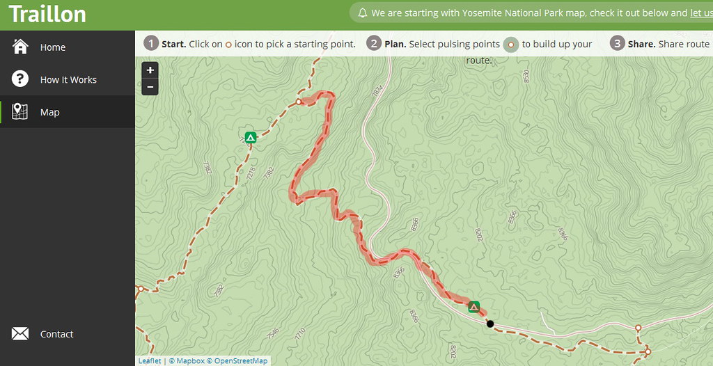
This is Old Tioga Road. It's not maintained. It's a difficult hike.
I would highly recommend that it be taken off a "planning" site. Or be designated
as "you really better know what you are getting into category".
The black dot is the parking area across Porcupine Creek campground. It is a trailhead.
That part should stay on... even though the hookup with North Dome trail is
not signed... it's in great shape and maintained.
I dunno why Old Tioga to Yose Creek campground is not on the map... or
Yosemite Creek. It's in same realm as all the lakes missing...
Anyway.. that's my 2 cents on this ...
This is really only the start...
Let's take a look at this...
This is Old Tioga Road. It's not maintained. It's a difficult hike.
I would highly recommend that it be taken off a "planning" site. Or be designated
as "you really better know what you are getting into category".
The black dot is the parking area across Porcupine Creek campground. It is a trailhead.
That part should stay on... even though the hookup with North Dome trail is
not signed... it's in great shape and maintained.
I dunno why Old Tioga to Yose Creek campground is not on the map... or
Yosemite Creek. It's in same realm as all the lakes missing...
Anyway.. that's my 2 cents on this ...
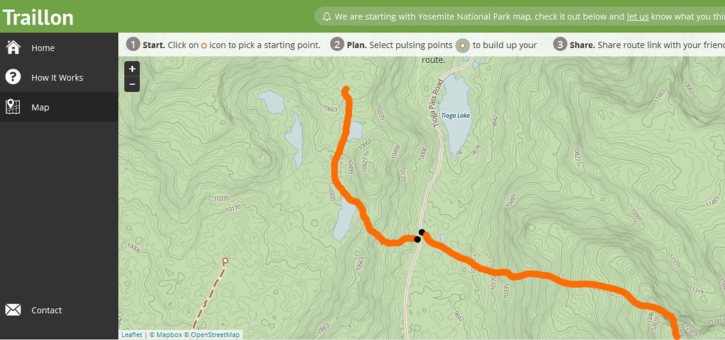
February 21, 2017 10:11AM | Moderator Registered: 15 years ago Posts: 7,421 |
Tenaya Lake area:
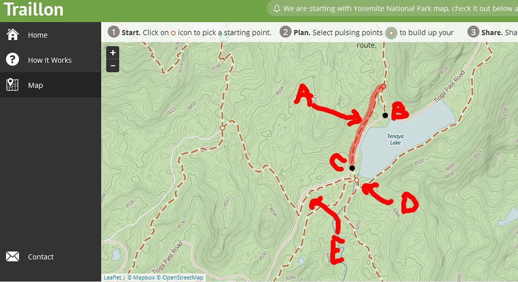
A - This trail is not signed on either side. Although it's on many maps and is actually in
really good shape... since it's not signed I would recommend that you remove it.
People will walk right by it... and in early season Murphy Creek is a barrier to crossing.
B/C - Sunrise / Murphy Creek Trailheads. I'd highly recommend that TH be used on
trailheads in the park. They would be very useful for planning for people not
hugely familiar with the park.
D - This area is not mapped correctly. You'll have to say you want it to be correct
and I can provide details.
E - same as D ... That connection exists... does it matter it's not drawn correctly?
Well... that's up what your goal is...
February 21, 2017 10:13AM | Moderator Registered: 15 years ago Posts: 7,421 |
February 21, 2017 10:15AM | Moderator Registered: 15 years ago Posts: 7,421 |
February 21, 2017 10:16AM | Moderator Registered: 15 years ago Posts: 7,421 |
February 21, 2017 10:19AM | Moderator Registered: 15 years ago Posts: 7,421 |
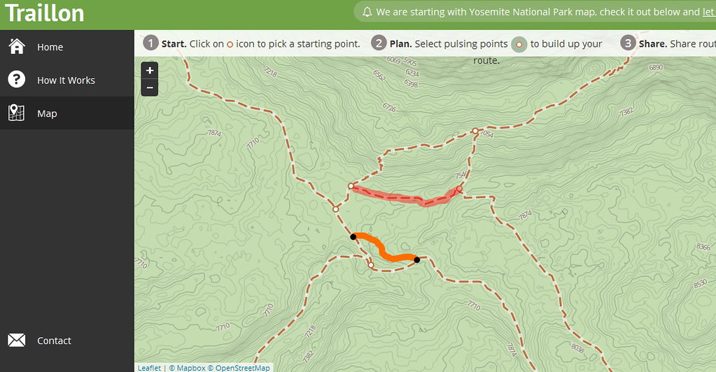
TM area:
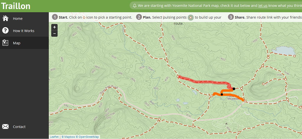
The red is the horse trail. Kinda on fence if should be left in. Most people shouldn't take it.
It's abuse by stock.
Orange is missing. Without question should be added.
Ok, I'll stop there. There's a LOT more ... say you want more or I won't do anymore.
Lots missing around Hetchy. Typical Smith Peak trail in wrong spot.
Missing Trails. Gravel Pit trail missing. Trail to Miguel missing. North or Laurel missing.
And so on
|
Re: Yosemite Hiking Map February 21, 2017 11:16PM | Registered: 8 years ago Posts: 5 |
February 22, 2017 07:49AM | Registered: 13 years ago Posts: 308 |
|
Re: Yosemite Hiking Map February 24, 2017 04:16PM | Registered: 8 years ago Posts: 8 |
Thanks rafal. I enjoyed tracing out a few possible routes and seeing what the mileage was. Helped me plan a few hikes for a possible future visit. And I particularly like the way the map auto-zoomed as you chose the next node in the journey. Very clever and the sort of feature that made the tool fun to use.
But I was a bit suspicious about the figures for uphill and downhill. So, I looked a bit more closely at a few trails, e.g., the Four Mile Trail. Whilst the net elevation gain in climbing from the Four Mile TH to the Panorama TH looked very plausible, I didn't believe the amount of downhill that would be involved (575ft). Looking more closely at how the trail "moves" over the contours and comparing it to the topo map, I thought either the contours or the trail on your map were a bit off. Now, I've never been anywhere near the Four Mile Trail (see below) but I reckon it's probably been engineered pretty well to avoid too much up and down. Yet on your map, there are sections of multiple zig-zags that actually zig up and zag down the contours (or is it the other way round - does one generally zig up ... or down ... dunno). Pretty crazy trail if it really does that.
So, I suppose my suggestion is that unless you can make the contours and/or trail mapping more accurate, the up and down measurements will be a bit too inaccurate to be worth giving.
Anyway newbie here. I've been lurking as a non-member for many months but only recently signed up with a view to asking a few questions in support of my plans to spend ~3 weeks in Yosemite and SEKI some time in the next few years (which would be my first visit to either). In those months, I've been reading and enjoying a lot of the archived threads, especially those about some of the less well known day-hikable destinations. E.g., I've been reading a few threads and pondering whether Sunnyside Bench would be a nice adjunct to a day wandering the length of the valley from Pohono Bridge to Royal Arches.
|
Re: Yosemite Hiking Map March 30, 2017 02:13PM | Registered: 8 years ago Posts: 5 |
Thanks Axis for sharing you thoughts - I'm aware that current contours are not 100 percent accurate and that they could be better - over time when we find better contours data provider we'd definitely like to improve it.
Recently we have updated the map with missing and incorrect trails taking into consideration all your comments. The update includes also adding outlying trailheads.
Additionally map tiles have been regenerated with the most recent OpenStreetMap data, so as a result there shouldn't be any missing lakes now.
If you guys find some mistakes in added data or if existing trails require more fixing, please let me know here
http://www.traillon.com/map/yosemite-national-park
Edited 2 time(s). Last edit at 03/30/2017 02:22PM by rafal.
Sorry, only registered users may post in this forum.

