I hit the jackpot with
Linda Wedel Greene's exhaustive documentation of park infrastructure. What a resource!
Here is what it looked like:
From Greene's description:
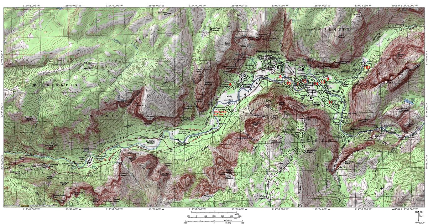
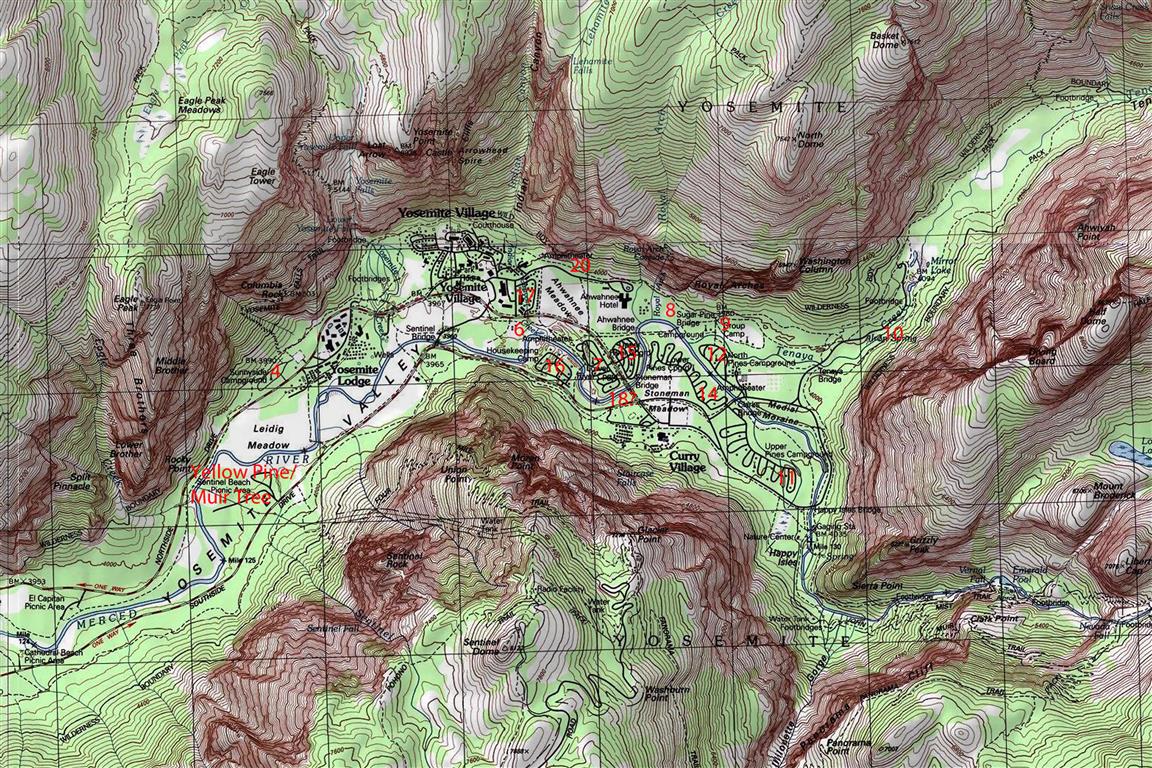
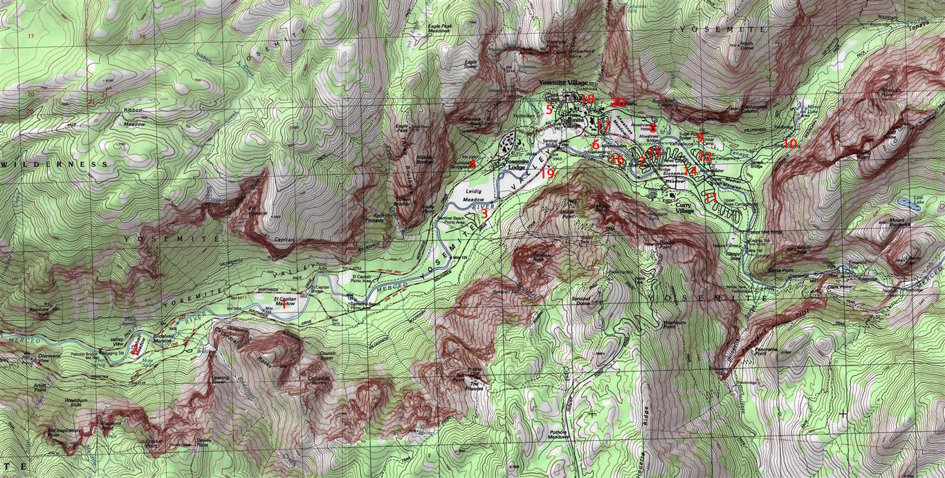
Camp No. 1 - EI Capitan Meadow. Early campers needed meadows for
pasturing their horses and mules. Abandoned for sanitary reasons
soon after 1906.
Camp No. 2 - Bridalveil Meadow. Used almost exclusively by army
troops when in the valley between 1890 and 1906. Abandoned for
sanitary reasons soon after 1906.
Camp No. 3 - west of Yosemite Village on the south side of the
Merced River in the trees at the west end of the meadow near Galen
Clark's house. Abandoned for sanitary reasons soon after 1906.
Camp No. 4 - Leidig Meadow, including portion of present Yosemite
Lodge grounds. Retired from public use upon establishment of army
headquarters in the valley. Abandoned for sanitary reasons also
soon after 1906.
Camp No. 5 - east of Yosemite Creek bridge, extending as far as the
apple orchard and Hutchings's cabin, including the area later
occupied by the park supervisor's home. Abandoned for sanitary
reasons soon after 1906.
Camp No. 6 - very old site. Later used by government and Yosemite
Park and Curry Company employees. Located south of present park
headquarters on north side of the Merced River.
Camp No. 7 - still in original location along Merced River north of
Camp Curry. Eventually divided by new road, creating two separate
camps. East portion became No. 15.
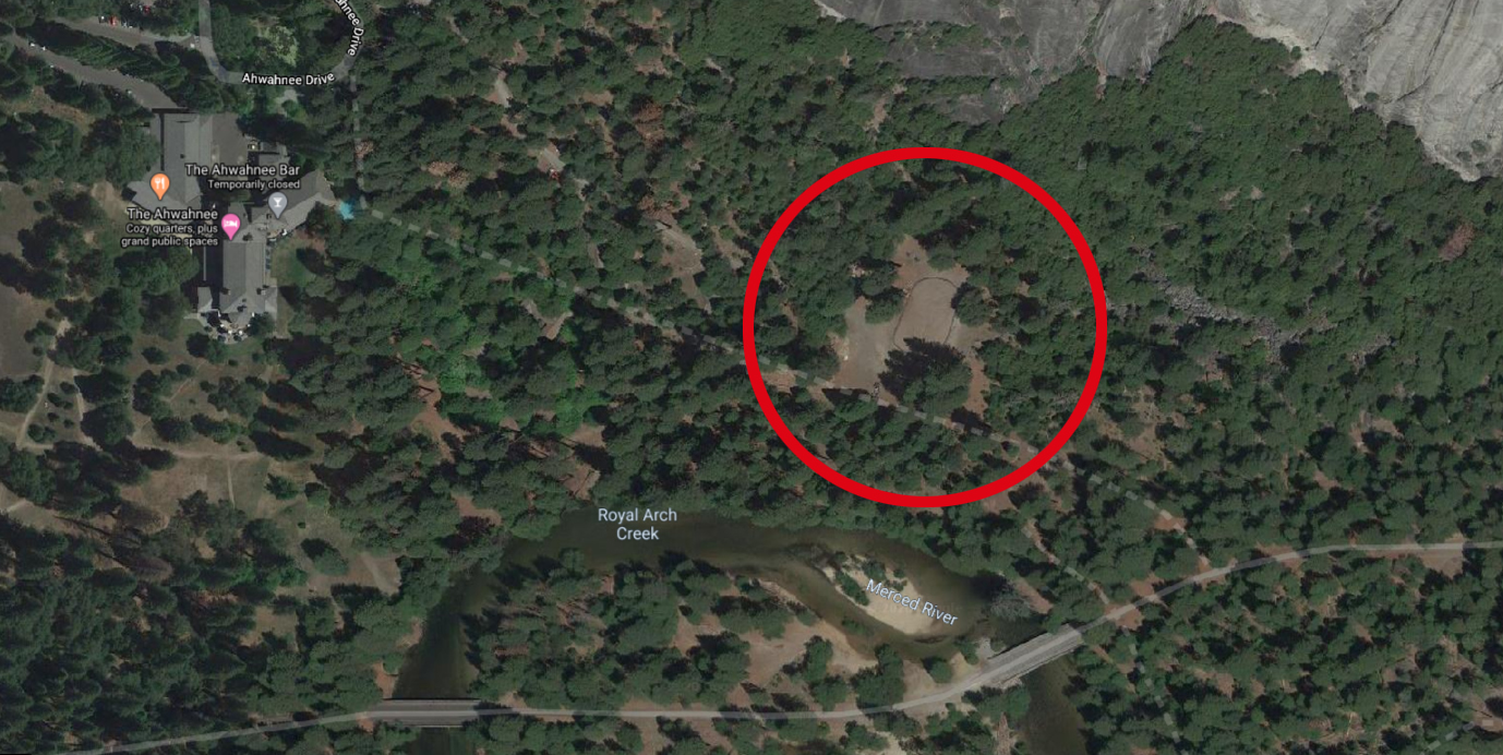
Camp No. 8 - located above Royal Arch Creek and included present
Ahwahnee Hotel grounds. Erection of the hotel in 1926 forced its
abandonment.
Camp No. 9 - old site on Tenaya Creek adjacent to and including
Royal Arch Meadow. Known as the "Organization Camp."
Camp No. 10 - near Iron Spring on Tenaya Creek, south of the old
Mirror Lake Road. Contained only limited space, and camping was
discouraged as demand for space in the area grew. Abandoned with
change of road alignment to Mirror Lake in the administration of
Superintendent Washington B. Lewis.
Camp No. 11 - originally intended to include the area now occupied
by the Curry Company stables and extending eastward, but that
area never functioned as a public campground. Number 11 was then
assigned to its present site south of Camp 14 on the road to Happy
Isles.
Camp No. 12 - located across the Merced River from Camp No. 14,
near Yosemite Park and Curry Company stables.
Camp No. 13 - never existed for reasons of superstition.
Camp No. 14 - still in original location, northeast of Camp Curry.
Camp No. 15 - one-half of original Camp No. 7.
Camp No. 16 - originally open to auto camping, but then reserved for
visitors desiring rental equipment and housekeeping facilities.
Northwest of Camp Curry on south side of Merced River.
Camp No. 17 - known at one time as "Camp Tecoya," later utilized for
permanent residences of employees of Yosemite Park and Curry
Company. (Now commonly referred to as Lower Tecoya)
Camp No. 18 - later occupied by post office and photographic studios
in New Village.
Camp No. 19 - formerly a public campground, then used exclusively
by government employees. Located about 600 feet southwest of
Sentinel Bridge. Beginning in 1912, the gradual segregation of
employees and park visitors in campgrounds began.
Camp No. 20 - now occupied by the Church Bowl.
This raises a few more questions but it answers a lot of other ones. For example, it makes sense why Roosevelt and Muir camped where they did in 1903, since Bridalveil Meadow was the main site for the army's encampment in the valley.
Also, a lot of the park's current infrastructure has roots back in the old campgrounds. The Yellow Pine / Muir Tree Campground from the 70's was not at the site of Camp 3, but pretty close.
Edited 1 time(s). Last edit at 08/09/2020 07:45PM by shastacatfish.